Okeanos Explorer (EX1403): East Coast Mapping and Exploration
EX1403
Multibeam, single beam, and subbottom sonar data will be
collected 24 hours a day. XBT casts will be conducted regularly for multibeam
calibration. The ship's Scientific Computing System (SCS) will monitor and
collect oceanographic, navigation, and meteorological data throughout the
cruise.
collected 24 hours a day. XBT casts will be conducted regularly for multibeam
calibration. The ship's Scientific Computing System (SCS) will monitor and
collect oceanographic, navigation, and meteorological data throughout the
cruise.
Cite this dataset when used as a source.
- ID not available.
gov.noaa.ncei:EX1403_COLLECTION
| Other Access | Online access information not available. |
| Distribution Formats | Format not available
|
| Distributor | Distributor information not available |
| Dataset Point of Contact | Derek Sowers UNH CCOM/JHC |
| Dataset processor | Derek Sowers UNH CCOM/JHC |
| Time Period | 2014-05-07T00:00:00 to 2014-05-22T00:00:00 |
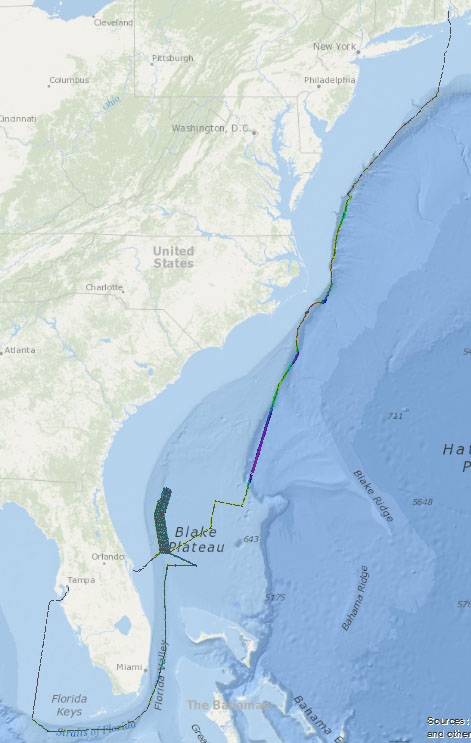
| Spatial Bounding Box Coordinates |
West:-82.9
East:-71.4
South:24.15
North:41.4
|
| Spatial Coverage Map | |
| Associated Resources |
|
| Publication Dates |
|
| Dataset Progress Status | Complete - production of the data has been completed |
| Data Update Frequency | Data update frequency not available |
| Purpose | EX1403 is an exploratory mapping expedition. Using deep water multibeam, single beam and sub-bottom profile data, EX will perform baseline characterization of highest priority areas based on feedback from other NOAA Offices, Programs, Labs and regional management councils. Top priority areas are focused on Marine Protected Areas in the South Atlantic off the east coast of the U.S. EX will also fill data gaps along the Atlantic continental slope. As a survey of opportunity, EX will test an advanced oxygen/argon sensor, to conduct shallow plankton tows to help assess if bluefin tuna are spawning over the Blake Plateau region, and to search for an underwater cultural heritage resource in the vicinity of the continental slope near Cape Hatteras. |
| Publishers |
|
| Acknowledgments |
|
| Theme keywords | None
|
| Place keywords | None
|
| Keywords | Ocean Exploration and Research (OER) Program Discovery Keywords
|
| Keywords | Ocean Exploration and Research (OER) Okeanos Explorer Discovery Keywords
|
| Keywords | Ocean Exploration and Research (OER) Marine Archaeology Keywords
|
| Use Constraints |
|
| Access Constraints |
|
| Fees | Fee information not available. |
| Instrument |
|
| Platform |
|
Last Modified: 2023-10-30T20:40:56
For questions about the information on this page, please email:ncei.info@noaa.gov