EX1301: Ship Shakedown and Patch Test Exploration, NE Canyons and Seamounts on NOAA Ship Okeanos Explorer between 20130318 and 20130405
EX-13-01;EX1301
Following annual ship shakedown and patch tests, EX1301 will complete the comprehensive
mapping of the Northeast canyons and the adjacent continental shelf carried out by
the cruises involved in the Atlantic Canyons Undersea Mapping Expeditions (ACUMEN)
2012 project.
Cite this dataset when used as a source.
- ID not available.
gov.noaa.ncei.oer.cruise:EX1301_COLLECTION
| Distribution Formats | Format not available
|
| Distributor | NOAA National Centers for Environmental Information ncei.info@noaa.gov |
| Dataset Point of Contact | Craig Russell 206-526-4803 craig.russell@noaa.gov |
| Dataset Principal Investigator | Elizabeth Lobecker |
| Dataset Originator | Lt. Laura Gallant ops.Explorer@noaa.gov |
| Time Period | 2013-03-18 to 2013-04-05 |
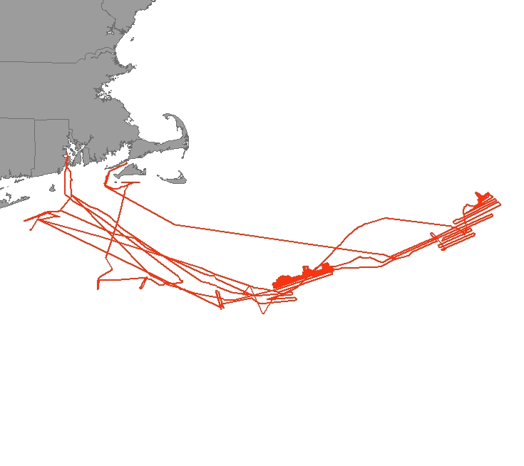
| Spatial Bounding Box Coordinates |
West:-71.4
East:-63.5
South:38.4
North:41.2
|
| Spatial Coverage Map | |
| General Documentation | |
| Associated Resources |
|
| Publication Dates |
|
| Dataset Progress Status | Complete - production of the data has been completed |
| Data Update Frequency | Unknown |
| Purpose | To perform 2013 ship shakedown and multibeam patch tests and to perform multibeam mapping surveys in the Northeast canyons. |
| Cited Authors |
|
| Principal Investigators |
|
| Publishers |
|
| Theme keywords | Global Change Master Directory (GCMD) Science Keywords
|
| Instrument keywords | Global Change Master Directory (GCMD) Instrument Keywords
|
| Place keywords | None
|
| Keywords | Ocean Exploration and Research (OER) Program Discovery Keywords
|
| Keywords | Ocean Exploration and Research (OER) Okeanos Explorer Discovery Keywords
|
| Use Constraints |
|
| Access Constraints |
|
| Fees | Fee information not available. |
| Instrument |
|
| Platform |
|
Last Modified: 2023-08-22T13:27:32
For questions about the information on this page, please email:ncei.info@noaa.gov