| Volcanic Ash Advisory Database, 1983-2003 | identificationInfo|
|---|---|
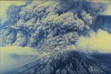
| а(MI_Metadata) ааааfileIdentifier: аgov.noaa.ngdc.mgg.hazards:G10073 ааааlanguage: аeng; USA ааааcharacterSet: а(MD_CharacterSetCode)аutf8 ааааhierarchyLevel: а(MD_ScopeCode)аdataset ааааcontact: а(CI_ResponsibleParty) ааааааааorganisationName: аNOAA National Centers for Environmental Information ааааааааpositionName: аHazards Data Manager ааааааааcontactInfo: а(CI_Contact) ааааааааааааaddress: а(CI_Address) ааааааааааааааааelectronicMailAddress: аhaz.info@noaa.gov ааааааааrole: а(CI_RoleCode)аpointOfContact ааааdateStamp: а2018-07-30 ааааmetadataStandardName: аISO 19115-2 Geographic Information - Metadata - Part 2: Extensions for Imagery and Gridded Data ааааmetadataStandardVersion: аISO 19115-2:2009(E) return to top ааааidentificationInfo: а(MD_DataIdentification) ааааааааcitation: а(CI_Citation) ааааааааааааtitle: аVolcanic Ash Advisory Database, 1983-2003 ааааааааааааdate: а(CI_Date) ааааааааааааааааdate: а2006-03-14 ааааааааааааааааdateType: а(CI_DateTypeCode)аpublication ааааааааааааcitedResponsibleParty: а(CI_ResponsibleParty) ааааааааааааааааorganisationName: аNOAA National Centers for Environmental Information ааааааааааааааааrole: а(CI_RoleCode)аpublisher ааааааааааааcitedResponsibleParty: а(CI_ResponsibleParty) ааааааааааааааааindividualName: аNicolas Arcos ааааааааааааааааorganisationName: аDOC/NOAA/NESDIS/NCEI > National Centers for Environmental Information, NESDIS, NOAA, U.S. Department of Commerce ааааааааааааааааcontactInfo: а(CI_Contact) ааааааааааааааааааааphone: а(CI_Telephone) ааааааааааааааааааааааааvoice: а(303) 497-3158 ааааааааааааааааааааааааfacsimile: а(303) 497-6513 ааааааааааааааааааааaddress: а(CI_Address) ааааааааааааааааааааааааdeliveryPoint: а325 Broadway, Mail Code E/NE42 ааааааааааааааааааааааааcity: аBoulder ааааааааааааааааааааааааadministrativeArea: аCO ааааааааааааааааааааааааpostalCode: а80305-3328 ааааааааааааааааааааааааcountry: аUSA ааааааааааааааааааааааааelectronicMailAddress: аhaz.info@noaa.gov ааааааааааааааааrole: а(CI_RoleCode)аpointOfContact ааааааааааааpresentationForm: а(CI_PresentationFormCode)аimageDigital ааааааааааааpresentationForm: а(CI_PresentationFormCode)аtableDigital ааааааааabstract: аVolcanic ash is a significant hazard to aviation and can also affect global climate patterns. To ensure safe navigation and monitor possible climatic impact, the NOAA Satellite Services Division (SSD) tracks volcanic ash eruptions throughout the world. After an eruption, SSD issues a Volcanic Ash Advisory (VAA) message and a forecast of ash location in the atmosphere from the Volcanic Ash Forecast Transport and Dispersion (VAFTAD) model. The Volcanic Ash Advisory Database contains VAA messages, VAFTAD model output, and substantiating information from 1983 to 2003, that have been scanned into image format. The substantiating information includes surface weather observations, pilot reports, volcanic observatory reports, news media reports, and satellite imagery for each event. This database is static and is no longer being updated by NCEI. ааааааааpurpose: аProvides volcanic ash modelers, climate analysts, and volcanologists with web-access to volcanic ash advisory data from past eruptive events. ааааааааcredit: аSatellite Products and Services Division of the National Environmental Satellite, Data, and Information Service (NESDIS) ааааааааstatus: а(MD_ProgressCode)аcompleted ааааааааpointOfContact: а(CI_ResponsibleParty) ааааааааааааindividualName: аNicolas Arcos ааааааааааааorganisationName: аDOC/NOAA/NESDIS/NCEI > National Centers for Environmental Information, NESDIS, NOAA, U.S. Department of Commerce ааааааааааааcontactInfo: а(CI_Contact) ааааааааааааааааphone: а(CI_Telephone) ааааааааааааааааааааvoice: а(303) 497-3158 ааааааааааааааааааааfacsimile: а(303) 497-6513 ааааааааааааааааaddress: а(CI_Address) ааааааааааааааааааааdeliveryPoint: а325 Broadway, Mail Code E/NE42 ааааааааааааааааааааcity: аBoulder ааааааааааааааааааааadministrativeArea: аCO ааааааааааааааааааааpostalCode: а80305-3328 ааааааааааааааааааааcountry: аUSA ааааааааааааааааааааelectronicMailAddress: аhaz.info@noaa.gov ааааааааааааrole: а(CI_RoleCode)аpointOfContact ааааааааresourceMaintenance: а(MD_MaintenanceInformation) ааааааааааааmaintenanceAndUpdateFrequency: а(MD_MaintenanceFrequencyCode)аnotPlanned ааааааааааааmaintenanceNote: аThere are no plans to update the data in this collection. ааааааааgraphicOverview: а(MD_BrowseGraphic) ааааааааааааfileName: https://www.ngdc.noaa.gov/hazard/icons/volcanoes.jpg ааааааааааааfileDescription: аMt. St. Helens ash cloud ааааааааааааfileType: аjpg ааааааааdescriptiveKeywords: а(MD_Keywords) ааааааааааааkeyword: аEarth Science > Solid Earth > Volcanoes ааааааааааааkeyword: аEarth Science > Solid Earth > Volcanoes > Eruption Dynamics ааааааааааааkeyword: аEarth Science > Solid Earth > Volcanoes > Volcanic Ash/Dust ааааааааааааtype: а(MD_KeywordTypeCode)аtheme ааааааааааааthesaurusName: а(CI_Citation) ааааааааааааааааtitle: аGlobal Change Master Directory (GCMD) Science Keywords ааааааааааааааааdate: а(CI_Date) ааааааааааааааааааааdate: а2020-01-09 ааааааааааааааааааааdateType: а(CI_DateTypeCode)аpublication ааааааааааааааааedition: а9.1 ааааааааааааааааcitedResponsibleParty: а(CI_ResponsibleParty) ааааааааааааааааааааorganisationName: аNASA Goddard Space Flight Center, Earth Science Data and Information System ааааааааааааааааааааcontactInfo: а(CI_Contact) ааааааааааааааааааааааааonlineResource: а(CI_OnlineResource) ааааааааааааааааааааааааааааlinkage: https://www.earthdata.nasa.gov/learn/find-data/idn/gcmd-keywords ааааааааааааааааааааааааааааname: аGlobal Change Master Directory (GCMD) Keywords ааааааааааааааааааааааааааааdescription: аThe information provided on this page seeks to define how the GCMD Keywords are structured, used and accessed. It also provides information on how users can participate in the further development of the keywords. ааааааааааааааааааааааааааааfunction: а(CI_OnLineFunctionCode)аinformation ааааааааааааааааааааrole: а(CI_RoleCode)аcustodian ааааааааdescriptiveKeywords: а(MD_Keywords) ааааааааааааkeyword: аICSU-WDS > International Council for Science - World Data System ааааааааааааtype: а(MD_KeywordTypeCode)аproject ааааааааааааthesaurusName: а(CI_Citation) ааааааааааааааааtitle: аGlobal Change Master Directory (GCMD) Project Keywords ааааааааааааааааdate: а(CI_Date) ааааааааааааааааааааdate: а2020-01-09 ааааааааааааааааааааdateType: а(CI_DateTypeCode)аpublication ааааааааааааааааedition: а9.1 ааааааааааааааааcitedResponsibleParty: а(CI_ResponsibleParty) ааааааааааааааааааааorganisationName: аNASA Goddard Space Flight Center, Earth Science Data and Information System ааааааааааааааааааааcontactInfo: а(CI_Contact) ааааааааааааааааааааааааonlineResource: а(CI_OnlineResource) ааааааааааааааааааааааааааааlinkage: https://www.earthdata.nasa.gov/learn/find-data/idn/gcmd-keywords ааааааааааааааааааааааааааааname: аGlobal Change Master Directory (GCMD) Keywords ааааааааааааааааааааааааааааdescription: аThe information provided on this page seeks to define how the GCMD Keywords are structured, used and accessed. It also provides information on how users can participate in the further development of the keywords. ааааааааааааааааааааааааааааfunction: а(CI_OnLineFunctionCode)аinformation ааааааааааааааааааааrole: а(CI_RoleCode)аcustodian ааааааааdescriptiveKeywords: а(MD_Keywords) ааааааааааааkeyword: аGlobal ааааааааааааtype: а(MD_KeywordTypeCode)аplace ааааааааааааthesaurusName: а(CI_Citation) ааааааааааааааааtitle: аGlobal Change Master Directory (GCMD) Location Keywords ааааааааааааааааdate: а(CI_Date) ааааааааааааааааааааdate: а2020-01-09 ааааааааааааааааааааdateType: а(CI_DateTypeCode)аpublication ааааааааааааааааedition: а9.1 ааааааааааааааааcitedResponsibleParty: а(CI_ResponsibleParty) ааааааааааааааааааааorganisationName: аNASA Goddard Space Flight Center, Earth Science Data and Information System ааааааааааааааааааааcontactInfo: а(CI_Contact) ааааааааааааааааааааааааonlineResource: а(CI_OnlineResource) ааааааааааааааааааааааааааааlinkage: https://www.earthdata.nasa.gov/learn/find-data/idn/gcmd-keywords ааааааааааааааааааааааааааааname: аGlobal Change Master Directory (GCMD) Keywords ааааааааааааааааааааааааааааdescription: аThe information provided on this page seeks to define how the GCMD Keywords are structured, used and accessed. It also provides information on how users can participate in the further development of the keywords. ааааааааааааааааааааааааааааfunction: а(CI_OnLineFunctionCode)аinformation ааааааааааааааааааааrole: а(CI_RoleCode)аcustodian ааааааааdescriptiveKeywords: а(MD_Keywords) ааааааааааааkeyword: аDOC/NOAA/NESDIS/NCEI > National Centers for Environmental Information, NESDIS, NOAA, U.S. Department of Commerce ааааааааааааkeyword: аDOC/NOAA/NESDIS/NGDC > National Geophysical Data Center, NESDIS, NOAA, U.S. Department of Commerce ааааааааааааtype: а(MD_KeywordTypeCode)аdataCentre ааааааааааааthesaurusName: а(CI_Citation) ааааааааааааааааtitle: аGlobal Change Master Directory (GCMD) Data Center Keywords ааааааааааааааааdate: а(CI_Date) ааааааааааааааааааааdate: а2020-01-09 ааааааааааааааааааааdateType: а(CI_DateTypeCode)аpublication ааааааааааааааааedition: а9.1 ааааааааааааааааcitedResponsibleParty: а(CI_ResponsibleParty) ааааааааааааааааааааorganisationName: аNASA Goddard Space Flight Center, Earth Science Data and Information System ааааааааааааааааааааcontactInfo: а(CI_Contact) ааааааааааааааааааааааааonlineResource: а(CI_OnlineResource) ааааааааааааааааааааааааааааlinkage: https://www.earthdata.nasa.gov/learn/find-data/idn/gcmd-keywords ааааааааааааааааааааааааааааname: аGlobal Change Master Directory (GCMD) Keywords ааааааааааааааааааааааааааааdescription: аThe information provided on this page seeks to define how the GCMD Keywords are structured, used and accessed. It also provides information on how users can participate in the further development of the keywords. ааааааааааааааааааааааааааааfunction: а(CI_OnLineFunctionCode)аinformation ааааааааааааааааааааrole: а(CI_RoleCode)аcustodian ааааааааresourceConstraints: а(MD_Constraints) ааааааааааааuseLimitation: аProduced by the NOAA National Centers for Environmental Information. Not subject to copyright protection within the United States. ааааааааresourceConstraints: а(MD_LegalConstraints) ааааааааааааaccessConstraints: а(MD_RestrictionCode)аotherRestrictions ааааааааааааotherConstraints: аDistribution liability: NOAA and NCEI make no warranty, expressed or implied, regarding these data, nor does the fact of distribution constitute such a warranty. NOAA and NCEI cannot assume liability for any damages caused by any errors or omissions in these data. If appropriate, NCEI can only certify that the data it distributes are an authentic copy of the records that were accepted for inclusion in the NCEI archives. ааааааааlanguage: аeng; USA ааааааааtopicCategory: а(MD_TopicCategoryCode)аclimatologyMeteorologyAtmosphere ааааааааextent: а(EX_Extent) ааааааааааааgeographicElement: а(EX_GeographicBoundingBox) ааааааааааааааааwestBoundLongitude: а-179 ааааааааааааааааeastBoundLongitude: а179 ааааааааааааааааsouthBoundLatitude: а-79 ааааааааааааааааnorthBoundLatitude: а89 ааааааааааааtemporalElement: а(EX_TemporalExtent) ааааааааааааааааextent: ааааааааааааааааааTimePeriod: ааааааааааааааааааааbeginPosition: а1983-07-18 ааааааааааааааааааааendPosition: а2003-02-23 return to top ааааcontentInfo: а(MI_CoverageDescription) ааааааааattributeDescription: ааааааааааRecordType: аVolcano Name ааааааааcontentType: а(MD_CoverageContentTypeCode)аreferenceInformation return to top ааааcontentInfo: а(MI_CoverageDescription) ааааааааattributeDescription: ааааааааааRecordType: аLocation ааааааааcontentType: а(MD_CoverageContentTypeCode)аcoordinate ааааааааdimension: а(MD_Band) ааааааааааааsequenceIdentifier: ааааааааааааааMemberName: ааааааааааааааааaName: аLatitude ааааааааааааааааattributeType: (unknown) ааааааааааааdescriptor: аDistance measured north or south from the equator. Distance north is positive, distance south is negative. ааааааааааааmaxValue: ааааааааааааааReal: а90.00000 ааааааааааааminValue: ааааааааааааааReal: а-90.00000 ааааааааааааunits: ааааааааааааааUnitDefinition: ааааааааааааааааidentifier: аdecimal degrees ааааааааааааааааname: аdecimal degrees ааааааааdimension: а(MD_Band) ааааааааааааsequenceIdentifier: ааааааааааааааMemberName: ааааааааааааааааaName: аLongitude ааааааааааааааааattributeType: (unknown) ааааааааааааdescriptor: аLongitude is measured from the Prime Meridian (which is the north/south line that runs through Greenwich, England), values measured east are positive and values measured west are negative. ааааааааааааmaxValue: ааааааааааааааReal: а180.00000 ааааааааааааminValue: ааааааааааааааReal: а-180.00000 ааааааааааааunits: ааааааааааааааUnitDefinition: ааааааааааааааааidentifier: аdecimal degrees ааааааааааааааааname: аdecimal degrees ааааааааdimension: а(MD_Band) ааааааааааааsequenceIdentifier: ааааааааааааааMemberName: ааааааааааааааааaName: аRegion ааааааааааааааааattributeType: (unknown) ааааааааааааdescriptor: аThe global region in which the volcano is located. return to top ааааcontentInfo: а(MI_CoverageDescription) ааааааааattributeDescription: ааааааааааRecordType: аDate of Volcanic Ash Advisory ааааааааcontentType: а(MD_CoverageContentTypeCode)аphysicalMeasurement return to top ааааcontentInfo: а(MI_CoverageDescription) ааааааааattributeDescription: ааааааааааRecordType: аType of Information ааааааааcontentType: а(MD_CoverageContentTypeCode)аthematicClassification ааааааааrangeElementDescription: а(MI_RangeElementDescription) ааааааааааааname: аType of Information ааааааааааааdefinition: аThe type of information, whether it be an advisory, model output, or substantiating information. ааааааааааааrangeElement: ааааааааааааааRecord: аSubstantiating Information ааааааааааааrangeElement: ааааааааааааааRecord: аVolcanic Ash Advisories and VAFTAD Output return to top ааааcontentInfo: а(MI_CoverageDescription) ааааааааattributeDescription: ааааааааааRecordType: аType of Image ааааааааcontentType: а(MD_CoverageContentTypeCode)аthematicClassification return to top ааааcontentInfo: а(MI_CoverageDescription) ааааааааattributeDescription: ааааааааааRecordType: аFilename ааааааааcontentType: а(MD_CoverageContentTypeCode)аreferenceInformation return to top ааааdistributionInfo: а(MD_Distribution) ааааааааdistributionFormat: а(MD_Format) ааааааааааааname: аjpeg ааааааааааааversion: (unknown) ааааааааdistributor: а(MD_Distributor) ааааааааааааdistributorContact: а(CI_ResponsibleParty) ааааааааааааааааorganisationName: аNOAA National Centers for Environmental Information ааааааааааааааааpositionName: аHazards Data Manager ааааааааааааааааcontactInfo: а(CI_Contact) ааааааааааааааааааааaddress: а(CI_Address) ааааааааааааааааааааааааelectronicMailAddress: аhaz.info@noaa.gov ааааааааааааааааrole: а(CI_RoleCode)аpointOfContact ааааааааааааdistributionOrderProcess: а(MD_StandardOrderProcess) ааааааааааааааааfees: аFree on the web ааааааааtransferOptions: а(MD_DigitalTransferOptions) ааааааааааааonLine: а(CI_OnlineResource) ааааааааааааааааlinkage: https://www.ngdc.noaa.gov/nndc/servlet/ShowDatasets?dataset=101597&search_look=39&display_look=39 ааааааааааааааааprotocol: аhttp ааааааааааааааааname: аVolcanic Ash Advisory Database Inventory Search ааааааааааааааааdescription: аUse this form to search the inventory of the volcanic ash advisory database. The Volcanic Ash Advisory Database contains VAA messages, VAFTAD model output, and substantiating information from 1983 to 2003, that have been scanned into image format. This database is static and is no longer being updated by NCEI. ааааааааааааааааfunction: а(CI_OnLineFunctionCode)аsearch return to top ааааdataQualityInfo: а(DQ_DataQuality) ааааааааscope: а(DQ_Scope) ааааааааааааlevel: а(MD_ScopeCode)аdataset ааааааааlineage: а(LI_Lineage) ааааааааааааstatement: аThis database was started in 2004 when Grace Swanson of the NOAA/NESDIS/Satellite Analysis Branch provided twenty years (1983 to 2003) of files containingаVolcanic Ash Advisory (VAA) messages issued by the Washington Volcanic Ash Advisory Center (VAAC), Volcanic Ash Forecast Transport and Dispersion (VAFTAD) model output, and substantiating information to the National Geophysical Data Center (NGDC) for archive and distribution. The documents were scanned into image format. The scanning effort was funded through the NOAA Earth Systems Data and Information Management (ESDIM) funding program. The purpose of the project was to provide examples to meteorological offices in other countries of the volcanic ash advisory decision-making process. ааааааааааааprocessStep: а(LI_ProcessStep) ааааааааааааааааdescription: аThe database was created in 2004 from twenty years of files containing Volcanic Ash Advisory (VAA) messages issued by the Washington Volcanic Ash Advisory Center (VAAC), Volcanic Ash Forecast Transport and Dispersion (VAFTAD) model output, and substantiating information to the National Geophysical Data Center (NGDC) for archive and distribution. ааааааааааааааааprocessor: а(CI_ResponsibleParty) ааааааааааааааааааааindividualName: аNatural Hazards Data Manager ааааааааааааааааааааorganisationName: аDOC/NOAA/NESDIS/NCEI > National Centers for Environmental Information, NESDIS, NOAA, U.S. Department of Commerce ааааааааааааааааааааrole: а(CI_RoleCode)аcustodian ааааааааааааsource: а(LI_Source) ааааааааааааааааdescription: аThis database was started in 2004 when Grace Swanson of the NOAA/NESDIS/Satellite Analysis Branch provided twenty years (1983 to 2003) of files containingаVolcanic Ash Advisory (VAA) messages issued by the Washington Volcanic Ash Advisory Center (VAAC), Volcanic Ash Forecast Transport and Dispersion (VAFTAD) model output, and substantiating information to the National Geophysical Data Center (NGDC) for archive and distribution. return to top ааааdataQualityInfo: а(DQ_DataQuality) ааааааааscope: а(DQ_Scope) ааааааааааааlevel: а(MD_ScopeCode)аdataset ааааааааreport: а(DQ_CompletenessCommission) ааааааааааааevaluationMethodDescription: аThe database is an accurate and complete representation of the decision-making process and algorithms that were used by the Washington Volcanic Ash Advisory Center (VAAC) during this time period. ааааааааааааresult: (unknown) return to top ааааdataQualityInfo: а(DQ_DataQuality) ааааааааscope: а(DQ_Scope) ааааааааааааlevel: а(MD_ScopeCode)аrepository ааааааааааааlevelDescription: а(MD_ScopeDescription) ааааааааааааааааother: аNOAA National Centers for Environmental Information ааааааааlineage: а(LI_Lineage) ааааааааааааprocessStep: а(LE_ProcessStep) ааааааааааааааааdescription: аNOAA created the National Centers for Environmental Information (NCEI) by merging NOAA's National Climatic Data Center (NCDC), National Geophysical Data Center (NGDC), and National Oceanographic Data Center (NODC), including the National Coastal Data Development Center (NCDDC), per the Consolidated and Further Continuing Appropriations Act, 2015, Public Law 113-235. NCEI launched publicly on April 22, 2015. ааааааааааааааааdateTime: ааааааааааааааааааDateTime: а2015-04-22T00:00:00 return to top ааааmetadataMaintenance: а(MD_MaintenanceInformation) ааааааааmaintenanceAndUpdateFrequency: а(MD_MaintenanceFrequencyCode)аunknown ааааааааmaintenanceNote: аThis record was automatically modified on 2015-10-01 to include references to NCEI where applicable. ааааааааcontact: а(CI_ResponsibleParty) ааааааааааааorganisationName: аNOAA National Centers for Environmental Information ааааааааааааpositionName: аMetadata Specialist ааааааааааааrole: а(CI_RoleCode)аeditor | |