| Hawaii Volcanism: Lava Forms | identificationInfo|
|---|---|
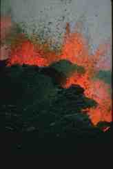
| а(MI_Metadata) ааааfileIdentifier: аgov.noaa.ngdc.mgg.photos:G01226 ааааlanguage: аeng; USA ааааcharacterSet: а(MD_CharacterSetCode)аutf8 ааааhierarchyLevel: а(MD_ScopeCode)аdataset ааааcontact: а(CI_ResponsibleParty) ааааааааorganisationName: аNOAA National Centers for Environmental Information ааааааааpositionName: аHazards Data Manager ааааааааcontactInfo: а(CI_Contact) ааааааааааааaddress: а(CI_Address) ааааааааааааааааelectronicMailAddress: аhaz.info@noaa.gov ааааааааrole: а(CI_RoleCode)аpointOfContact ааааdateStamp: а2018-09-27 ааааmetadataStandardName: аISO 19115-2 Geographic Information - Metadata - Part 2: Extensions for Imagery and Gridded Data ааааmetadataStandardVersion: аISO 19115-2:2009(E) return to top ааааidentificationInfo: а(MD_DataIdentification) ааааааааcitation: а(CI_Citation) ааааааааааааtitle: аHawaii Volcanism: Lava Forms ааааааааааааdate: а(CI_Date) ааааааааааааааааdate: а1994 ааааааааааааааааdateType: а(CI_DateTypeCode)аpublication ааааааааааааedition: аFirst ааааааааааааidentifier: а(MD_Identifier) ааааааааааааааааcode: аDocument ааааааааааааcitedResponsibleParty: а(CI_ResponsibleParty) ааааааааааааааааorganisationName: аNOAA National Centers for Environmental Information ааааааааааааааааrole: а(CI_RoleCode)аpublisher ааааааааааааcitedResponsibleParty: а(CI_ResponsibleParty) ааааааааааааааааorganisationName: аDOC/NOAA/NESDIS/NGDC > National Geophysical Data Center, NESDIS, NOAA, U.S. Department of Commerce (comp) ааааааааааааааааrole: а(CI_RoleCode)аoriginator ааааааааааааcitedResponsibleParty: а(CI_ResponsibleParty) ааааааааааааааааorganisationName: аNational Geophysical Data Center ааааааааааааааааcontactInfo: а(CI_Contact) ааааааааааааааааааааaddress: а(CI_Address) ааааааааааааааааааааааааcity: аBoulder ааааааааааааааааааааааааadministrativeArea: аCO ааааааааааааааааrole: а(CI_RoleCode)аpublisher ааааааааааааpresentationForm: ааааааааabstract: аOver the last several million years the Hawaiian Islands have been built of successive lava flows. They are the most recent additions in a long line of volcanoes that extends up the intersection ofthe Aleutian Island chain with the Kamchatka peninsula. This set includes very colorful imagesof lava fountains, lakes, cascades, flows, spatter and lava entry to the sea from eruptionsoccurring over the last 30 years. Most of these volcanoes are no longer visible above the sea surface. These islands and sea mounts formed as the Pacific plate moved over a hot spot in Earth's mantle. The amount of lava that has erupted here is difficult to comprehend. Mauna Loa, on the Island of Hawaii (Big Island) is the largest volcanic structure in the world with a volume estimated at 42,000 km3. It rises from the ocean floor, 5,000 m below sea level, to a height above sea level of 4,172 meters. In addition to eruptions at the summit, Hawaiian volcanoes have flank eruptions with lavaflowing several kilometers from the vent. The height of such volcanic structures (known as shield volcanoes) increases only slightly while they continually grow in width. Hawaii's usually non-explosive eruptions are characterized by the relatively quiet outpouring of lava known as effusive eruptions. High temperature, a low gas content, and exceptionally fluid lava are typical of these eruptions. The high fluidity of Hawaiian lava comes from its basaltic composition. They are contrasted to the more viscous dacite erupted explosively at Mount Saint Helens in 1980. Hawaiian eruptions usually start with lava issuing vertically from a central vent or a fissure in a rhythmic jet-like eruption, called a lava fountain. The lava fountains vary widely in form, size and duration depending on the shape of the vent, volume of lava, and other conditions. Fountains spouting from a series of nearly continuous fissures are called curtains of fire. As the eruption proceeds the lava fountain activity is confined to a single vent or opening. The lava may form lava lakes of fluid rock in summit craters or in pit craters on the flanks of the volcanoes. If the lava lake forms around an active vent, the crust breaks up in response to circulation and sloshing of the molten lavabeneath. Lava falling from fountains and flowing from vents often forms glowing lava streams or lava flows. During some Mauna Loa eruptions flows rushed down the steep slopes at 58 km per hour. As the eruption continues, the lava solidifies along the edges of the flow building levees or ramparts that allow the level of the lava to be raised. If the roof of the channel hardens and forms a solid crust the molten lava may continue to flow within what has become a lava tube. Lava tubes generally have arched roofs but their floors may be flat, formed by the surface of the last liquid lava to move through them. The walls of such tubes become thermal insulators allowing the lava to flow greater distances from the vent. Lava streams that plunge over cliffs or the steep walls of craters form lava cascades or lava falls. There are two main types of lava flows: pahoehoe, and aa. The Hawaiian names refer to the surface character of the lava. Many flows consist ofpahoehoe upstream and change to aa downstream. However, aa flows do not change into pahoehoe. The type of lava is determined by the initial gascontent of the lava, the changes in lava viscosity and the rate of deformation (shear strain of the lava during flow and cooling). Pahoehoe has a smooth surface. In some areas it is wrinkled and twisted resembling folds in heavy cloth. This appearance results from the dragging and twisting of the thin, hot, still-plastic crust of the flow by movement of the liquid lava underneath. The surfaces of most pahoehoeflows are rolling or undulating. One can walk across a moving flow, and although the crust may bend, it does not break. The crust of a lava flow is a poor conductor of heat so the part of the flow beneath the crust may remain hot and liquid for long periods. Shrinkage on cooling and distortion by the movement of the liquid beneath it causes fractures in the crust. The interior of thick flows may remain liquid for weeks, months, or year. A is characterized by a rough, rubbled surface. The layer of angular jagged fragments is known as clinker. The streams of molten lava that feedaa flows usually do not "freeze over" like those of pahoehoe and therefore seldom form lava tubes. Close to the vent the surface of the aa stream maybe smooth orange-hot lava that quickly becomes covered with a lead-gray glassy skin. As the crust is disrupted by movement of the flow beneath it the characteristic spiny surface begins to appear. When lava flows reach a shore line and encounter the ocean, littoral (coastal) explosions can occur. A lava flow within a body of water formspillow lava. Each pillow is enclosed in a thin skin of glass. The pillows accumulate by settling one on top of another while they are stillsufficiently plastic to mold themselves to the underlying surface. Evidence of rapid chilling and close association with water deposited sediments indicates clearly that pillow lavas were formed either beneath water or by extrusion over very wet swampy surfaces. The Islands of Hawaii provide an excellent location for the study of the many and varied forms of lava. ааааааааpurpose: аMake available Damage Photos for research and education ааааааааcredit: аPatricia Lockridge ааааааааstatus: а(MD_ProgressCode)аcompleted ааааааааpointOfContact: а(CI_ResponsibleParty) ааааааааааааorganisationName: аNOAA National Centers for Environmental Information ааааааааааааpositionName: аHazards Data Manager ааааааааааааcontactInfo: а(CI_Contact) ааааааааааааааааaddress: а(CI_Address) ааааааааааааааааааааelectronicMailAddress: аhaz.info@noaa.gov ааааааааааааrole: а(CI_RoleCode)аpointOfContact ааааааааresourceMaintenance: а(MD_MaintenanceInformation) ааааааааааааmaintenanceAndUpdateFrequency: а(MD_MaintenanceFrequencyCode)аnotPlanned ааааааааgraphicOverview: а(MD_BrowseGraphic) ааааааааааааfileName: https://www.ngdc.noaa.gov/hazard/icons/small_res/33/33_664.jpg ааааааааааааfileDescription: аView of curtains of fire, main vents, and rampart built by spatter at 2,800 m elevation on Mauna Loa, March 26, 1984. This discontinuous row of lava fountains 15-30 m high occurs along a rift. The eruption which began on March 25 fed several lava flows, one of which threatened the City of Hilo. However, the activity stopped in early April and the flows stopped about 6.4 km short of the outskirts of the city. ааааааааааааfileType: аJPEG ааааааааdescriptiveKeywords: а(MD_Keywords) ааааааааааааkeyword: аEARTH SCIENCE > SOLID EARTH > Volcanoes > Eruption Dynamics ааааааааааааkeyword: аEARTH SCIENCE > SOLID EARTH > Volcanoes > Lava ааааааааааааkeyword: аEARTH SCIENCE > SOLID EARTH > Volcanoes > Magma ааааааааааааkeyword: аEARTH SCIENCE > SOLID EARTH > Volcanoes > Pyroclastics ааааааааааааkeyword: аEARTH SCIENCE > SOLID EARTH > Volcanoes > Volcanic Ash/Dust ааааааааааааtype: а(MD_KeywordTypeCode)аtheme ааааааааааааthesaurusName: а(CI_Citation) ааааааааааааааааtitle: аNASA/GCMD Earth Science Keywords ааааааааааааааааdate: (unknown) ааааааааdescriptiveKeywords: а(MD_Keywords) ааааааааааааkeyword: аINFOTERRA > Lithosphere > Seismic activity > Seismic activity ааааааааааааkeyword: аINFOTERRA > Lithosphere > Volcanoes > Volcanoes ааааааааааааtype: а(MD_KeywordTypeCode)аtheme ааааааааааааthesaurusName: а(CI_Citation) ааааааааааааааааtitle: аINFOTERRA Keyword Thesaurus ааааааааааааааааdate: (unknown) ааааааааdescriptiveKeywords: а(MD_Keywords) ааааааааааааkeyword: аICSU-WDS > International Council for Science - World Data System ааааааааааааtype: а(MD_KeywordTypeCode)аproject ааааааааааааthesaurusName: а(CI_Citation) ааааааааааааааааtitle: аGlobal Change Master Directory (GCMD) Project Keywords ааааааааааааааааdate: а(CI_Date) ааааааааааааааааааааdate: а2020-01-09 ааааааааааааааааааааdateType: а(CI_DateTypeCode)аpublication ааааааааааааааааedition: а9.1 ааааааааааааааааcitedResponsibleParty: а(CI_ResponsibleParty) ааааааааааааааааааааorganisationName: аNASA Goddard Space Flight Center, Earth Science Data and Information System ааааааааааааааааааааcontactInfo: а(CI_Contact) ааааааааааааааааааааааааonlineResource: а(CI_OnlineResource) ааааааааааааааааааааааааааааlinkage: https://www.earthdata.nasa.gov/learn/find-data/idn/gcmd-keywords ааааааааааааааааааааааааааааname: аGlobal Change Master Directory (GCMD) Keywords ааааааааааааааааааааааааааааdescription: аThe information provided on this page seeks to define how the GCMD Keywords are structured, used and accessed. It also provides information on how users can participate in the further development of the keywords. ааааааааааааааааааааааааааааfunction: а(CI_OnLineFunctionCode)аinformation ааааааааааааааааааааrole: а(CI_RoleCode)аcustodian ааааааааdescriptiveKeywords: а(MD_Keywords) ааааааааааааkeyword: аNorth and Central America > United States > Hawaii ааааааааааааtype: а(MD_KeywordTypeCode)аplace ааааааааааааthesaurusName: а(CI_Citation) ааааааааааааааааtitle: аGetty Thesaurus of Geographic Names ааааааааааааааааdate: (unknown) ааааааааdescriptiveKeywords: а(MD_Keywords) ааааааааааааkeyword: аDOC/NOAA/NESDIS/NCEI > National Centers for Environmental Information, NESDIS, NOAA, U.S. Department of Commerce ааааааааааааkeyword: аDOC/NOAA/NESDIS/NGDC > National Geophysical Data Center, NESDIS, NOAA, U.S. Department of Commerce ааааааааааааtype: а(MD_KeywordTypeCode)аdataCentre ааааааааааааthesaurusName: а(CI_Citation) ааааааааааааааааtitle: аGlobal Change Master Directory (GCMD) Data Center Keywords ааааааааааааааааdate: а(CI_Date) ааааааааааааааааааааdate: а2020-01-09 ааааааааааааааааааааdateType: а(CI_DateTypeCode)аpublication ааааааааааааааааedition: а9.1 ааааааааааааааааcitedResponsibleParty: а(CI_ResponsibleParty) ааааааааааааааааааааorganisationName: аNASA Goddard Space Flight Center, Earth Science Data and Information System ааааааааааааааааааааcontactInfo: а(CI_Contact) ааааааааааааааааааааааааonlineResource: а(CI_OnlineResource) ааааааааааааааааааааааааааааlinkage: https://www.earthdata.nasa.gov/learn/find-data/idn/gcmd-keywords ааааааааааааааааааааааааааааname: аGlobal Change Master Directory (GCMD) Keywords ааааааааааааааааааааааааааааdescription: аThe information provided on this page seeks to define how the GCMD Keywords are structured, used and accessed. It also provides information on how users can participate in the further development of the keywords. ааааааааааааааааааааааааааааfunction: а(CI_OnLineFunctionCode)аinformation ааааааааааааааааааааrole: а(CI_RoleCode)аcustodian ааааааааresourceConstraints: а(MD_LegalConstraints) ааааааааааааaccessConstraints: а(MD_RestrictionCode)аotherRestrictions ааааааааааааuseConstraints: а(MD_RestrictionCode)аotherRestrictions ааааааааааааotherConstraints: аAccess Constraints: None Use Constraints: None Distribution Liability: While every effort has been made to ensure that these data are accurate and reliable within the limits of the current state of the art, NOAA cannot assume liability for any damages caused by any errors or omissions in the data, nor as a result of the failure of the data to function on a particular system. NOAA makes no warranty, expressed or implied, nor does the fact of distribution constitute such a warranty. ааааааааaggregationInfo: а(MD_AggregateInformation) ааааааааааааaggregateDataSetIdentifier: а(MD_Identifier) ааааааааааааааааauthority: а(CI_Citation) ааааааааааааааааааааtitle: аContainer Packet ID ааааааааааааааааааааdate: (unknown) ааааааааааааааааcode: аG01143 ааааааааааааassociationType: а(DS_AssociationTypeCode) ааааааааlanguage: аeng; USA ааааааааtopicCategory: а(MD_TopicCategoryCode)аgeoscientificInformation ааааааааextent: а(EX_Extent) ааааааааааааgeographicElement: а(EX_GeographicBoundingBox) ааааааааааааааааwestBoundLongitude: а-158.17 ааааааааааааааааeastBoundLongitude: а-155.29 ааааааааааааааааsouthBoundLatitude: а19.42 ааааааааааааааааnorthBoundLatitude: а21.35 ааааааааааааtemporalElement: а(EX_TemporalExtent) ааааааааааааааааextent: ааааааааааааааааааTimePeriod: ааааааааааааааааааааdescription: аPublication Date ааааааааааааааааааааbeginPosition: а1959-12-00 ааааааааааааааааааааendPosition: а1990-02-00 return to top ааааcontentInfo: return to top ааааdistributionInfo: а(MD_Distribution) ааааааааdistributionFormat: а(MD_Format) ааааааааааааname: аTIFF ааааааааааааversion: (unknown) ааааааааdistributor: а(MD_Distributor) ааааааааааааdistributorContact: а(CI_ResponsibleParty) ааааааааааааааааorganisationName: аDOC/NOAA/NESDIS/NCEI > National Centers for Environmental Information, NESDIS, NOAA, U.S. Department of Commerce ааааааааааааааааpositionName: аUser Services ааааааааааааааааcontactInfo: а(CI_Contact) ааааааааааааааааааааphone: а(CI_Telephone) ааааааааааааааааааааааааvoice: а303-497-6826 ааааааааааааааааааааааааfacsimile: а303-497-6513 ааааааааааааааааааааaddress: а(CI_Address) ааааааааааааааааааааааааdeliveryPoint: а325 Broadway ааааааааааааааааааааааааcity: аBoulder ааааааааааааааааааааааааadministrativeArea: аCO ааааааааааааааааааааааааpostalCode: а80305-3328 ааааааааааааааааааааааааcountry: аUSA ааааааааааааааааааааааааelectronicMailAddress: аngdc.info@noaa.gov ааааааааааааааааааааhoursOfService: а8am-5pm, Monday through Friday ааааааааааааааааrole: а(CI_RoleCode)аdistributor ааааааааtransferOptions: а(MD_DigitalTransferOptions) ааааааааааааtransferSize: ааааааааааааааReal: а21764 ааааааааааааonLine: а(CI_OnlineResource) ааааааааааааааааlinkage: https://www.ngdc.noaa.gov/hazardimages/ ааааааааааааonLine: а(CI_OnlineResource) ааааааааааааааааlinkage: https://www.ngdc.noaa.gov/hazard/ ааааааааtransferOptions: а(MD_DigitalTransferOptions) ааааааааааааoffLine: а(MD_Medium) ааааааааааааааааname: а(MD_MediumNameCode)аcdRom ааааааааааааааааmediumFormat: а(MD_MediumFormatCode)аiso9660 return to top ааааdataQualityInfo: а(DQ_DataQuality) ааааааааscope: а(DQ_Scope) ааааааааааааlevel: а(MD_ScopeCode)аrepository ааааааааааааlevelDescription: а(MD_ScopeDescription) ааааааааааааааааother: аNOAA National Centers for Environmental Information ааааааааlineage: а(LI_Lineage) ааааааааааааprocessStep: а(LE_ProcessStep) ааааааааааааааааdescription: аNOAA created the National Centers for Environmental Information (NCEI) by merging NOAA's National Climatic Data Center (NCDC), National Geophysical Data Center (NGDC), and National Oceanographic Data Center (NODC), including the National Coastal Data Development Center (NCDDC), per the Consolidated and Further Continuing Appropriations Act, 2015, Public Law 113-235. NCEI launched publicly on April 22, 2015. ааааааааааааааааdateTime: ааааааааааааааааааDateTime: а2015-04-22T00:00:00 return to top ааааmetadataMaintenance: а(MD_MaintenanceInformation) ааааааааmaintenanceAndUpdateFrequency: (unknown) ааааааааmaintenanceNote: аThis metadata was automatically generated from the Content Standard for Digital Geospatial Metadata: Extensions for Remote Sensing Metadata standard version FGDC-STD-012-2002 using the June 2011 version of the FGDC RSE to ISO 19115-2 transform. The Spatial Reference Information is not currently mapped over to ISO but will be mapped in future versions. ааааааааmaintenanceNote: аThis record was automatically modified on 2015-10-14 to include references to NCEI where applicable. ааааааааcontact: а(CI_ResponsibleParty) ааааааааааааorganisationName: аNOAA National Centers for Environmental Information ааааааааааааpositionName: аMetadata Specialist ааааааааааааrole: а(CI_RoleCode)аeditor ааааааааcontact: а(CI_ResponsibleParty) ааааааааааааorganisationName: аNOAA National Centers for Environmental Information ааааааааааааpositionName: аHazards Data Manager ааааааааааааcontactInfo: а(CI_Contact) ааааааааааааааааaddress: а(CI_Address) ааааааааааааааааааааelectronicMailAddress: аhaz.info@noaa.gov ааааааааааааrole: а(CI_RoleCode)аpointOfContact | |