| EMAG2v3: Earth Magnetic Anomaly Grid (2-arc-minute resolution) | spatialRepresentationInfo|
|---|---|
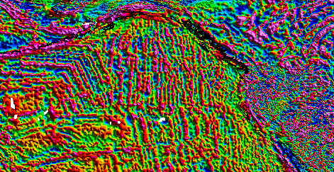
| (MI_Metadata) fileIdentifier: gov.noaa.ngdc.mgg.geophysical_models:EMAG2_V3 hierarchyLevel: (MD_ScopeCode) dataset contact: (CI_ResponsibleParty) organisationName: Anchor: ROR ID NOAA National Centers for Environmental Information contactInfo: (CI_Contact) address: (CI_Address) electronicMailAddress: ncei.info@noaa.gov onlineResource: (CI_OnlineResource) linkage: https://www.ncei.noaa.gov/contact name: NCEI Contact Information description: Information for contacts at NCEI. function: (CI_OnLineFunctionCode) information role: (CI_RoleCode) pointOfContact dateStamp: 2020-05-14 metadataStandardName: ISO 19115-2 Geographic Information - Metadata - Part 2: Extensions for Imagery and Gridded Data metadataStandardVersion: ISO 19115-2:2009(E) return to top spatialRepresentationInfo: (MD_GridSpatialRepresentation) numberOfDimensions: 2 axisDimensionProperties: (MD_Dimension) dimensionName: (MD_DimensionNameTypeCode) row dimensionSize: 10801 resolution: Distance: .0333 axisDimensionProperties: (MD_Dimension) dimensionName: (MD_DimensionNameTypeCode) column dimensionSize: 5401 resolution: Distance: .0333 cellGeometry: (MD_CellGeometryCode) area transformationParameterAvailability: true return to top referenceSystemInfo: (MD_ReferenceSystem) referenceSystemIdentifier: (RS_Identifier) authority: (CI_Citation) title: World Geodetic System 1984 alternateTitle: WGS 84 date: (CI_Date) date: 2007-08-27 dateType: (CI_DateTypeCode) revision citedResponsibleParty: (CI_ResponsibleParty) organisationName: (withheld) contactInfo: (CI_Contact) onlineResource: (CI_OnlineResource) linkage: https://epsg.org/crs_4326/WGS-84.html name: WGS 84 description: GML of World Geodetic System 1984 coordinate reference system. function: (CI_OnLineFunctionCode) information role: (CI_RoleCode) resourceProvider citedResponsibleParty: (CI_ResponsibleParty) organisationName: European Petroleum Survey Group contactInfo: (CI_Contact) onlineResource: (CI_OnlineResource) linkage: https://epsg.org/home.html name: European Petroleum Survey Group Geodetic Parameter Registry description: Registry that accesses the EPSG Geodetic Parameter Dataset, which is a structured dataset of Coordinate Reference Systems and Coordinate Transformations. function: (CI_OnLineFunctionCode) search role: (CI_RoleCode) publisher code: urn:ogc:def:crs:EPSG::4326 return to top identificationInfo: (MD_DataIdentification) citation: (CI_Citation) title: EMAG2v3: Earth Magnetic Anomaly Grid (2-arc-minute resolution) date: (CI_Date) date: 2017-05-30 dateType: (CI_DateTypeCode) publication edition: Version 3 editionDate: 2017-05-30 identifier: (MD_Identifier) authority: (CI_Citation) title: International DOI Foundation (IDF) date: (inapplicable) code: Anchor: DOI doi:10.7289/V5H70CVX identifier: (MD_Identifier) authority: (CI_Citation) title: NOAA National Centers for Environmental Information date: (inapplicable) code: NCEI Metadata ID: gov.noaa.ngdc.mgg.geophysical_models:EMAG2_V3 citedResponsibleParty: (CI_ResponsibleParty) organisationName: NOAA National Centers for Environmental Information role: (CI_RoleCode) publisher citedResponsibleParty: (CI_ResponsibleParty) positionName: NCEI Geomagnetic Modeling Team role: (CI_RoleCode) originator citedResponsibleParty: (CI_ResponsibleParty) individualName: Brian Meyer role: (CI_RoleCode) author citedResponsibleParty: (CI_ResponsibleParty) individualName: Richard Saltus role: (CI_RoleCode) author citedResponsibleParty: (CI_ResponsibleParty) individualName: Arnaud Chulliat role: (CI_RoleCode) author presentationForm: (CI_PresentationFormCode) mapDigital abstract: EMAG2v3 is a global Earth Magnetic Anomaly Grid compiled from satellite, ship, and airborne magnetic measurements. It is a significant update of the previous release of the Earth Magnetic Anomaly Grid. The resolution remains 2 arc-minutes, and the altitude of 4 km above the geoid is still supported, but an additional product, a grid that is observed at sea-level over oceanic regions, has been produced. New additions grid and track line data have been included, both over land and the oceans. Wherever available, the original shipborne and airborne data were used instead of precompiled oceanic magnetic grids. Interpolation between sparse track lines in the oceans was improved by using a kriging algorithm, which specializes in heterogeneous data distribution gridding, in order to create a compilation as true to the observed data as possible, and avoid using a priori information. The longest wavelengths (>300 km) were replaced with the latests satellite lithosphere magnetic field model, MF7. purpose: Magnetic anomaly maps provide insight into the subsurface structure and composition of the Earth's crust. Over continental areas, magnetic anomalies illuminate geologic, tectonic, and geothermal evolution of crust and lithosphere. In the world's oceans, anomalies trending parallel to the isochrons (lines of equal age) reveal the temporal evolution of oceanic crust. Magnetic maps are widely used in the geological sciences and in resource exploration. status: (MD_ProgressCode) completed status: (MD_ProgressCode) historicalArchive pointOfContact: (CI_ResponsibleParty) organisationName: Anchor: ROR ID NOAA National Centers for Environmental Information contactInfo: (CI_Contact) address: (CI_Address) electronicMailAddress: ncei.info@noaa.gov onlineResource: (CI_OnlineResource) linkage: https://www.ncei.noaa.gov/contact name: NCEI Contact Information description: Information for contacts at NCEI. function: (CI_OnLineFunctionCode) information role: (CI_RoleCode) pointOfContact pointOfContact: (CI_ResponsibleParty) organisationName: NOAA National Centers for Environmental Information positionName: NCEI Geomagnetic Modeling Team contactInfo: (CI_Contact) address: (CI_Address) electronicMailAddress: geomag.models@noaa.gov role: (CI_RoleCode) pointOfContact resourceMaintenance: (MD_MaintenanceInformation) maintenanceAndUpdateFrequency: (MD_MaintenanceFrequencyCode) asNeeded graphicOverview: (MD_BrowseGraphic) fileName: http://www.ngdc.noaa.gov/geomag/image/EMAG2_V3_UpCont_WestCoastUS.png fileDescription: EMAG2v3 showing the west coast of the United States and Canada. The stripes are magnetic lineations due to sea-floor spreading. fileType: png descriptiveKeywords: (MD_Keywords) keyword: Earth Science > Solid Earth > Geomagnetism > Magnetic Field keyword: Earth Science > Solid Earth > Geomagnetism > Magnetic Intensity keyword: Earth Science > Solid Earth > Geomagnetism > Magnetic Anomalies type: (MD_KeywordTypeCode) theme thesaurusName: (CI_Citation) title: Global Change Master Directory (GCMD) Science Keywords date: (CI_Date) date: 2024 dateType: (CI_DateTypeCode) revision edition: 19 citedResponsibleParty: (CI_ResponsibleParty) organisationName: Earth Science Data and Information System, Earth Science Projects Division, Goddard Space Flight Center (GSFC), National Aeronautics and Space Administration (NASA) contactInfo: (CI_Contact) onlineResource: (CI_OnlineResource) linkage: https://forum.earthdata.nasa.gov/app.php/tag/GCMD%2BKeywords name: GCMD Keyword Forum Page description: Global Change Master Directory (GCMD). 2024. GCMD Keywords, Version 19. Greenbelt, MD: Earth Science Data and Information System, Earth Science Projects Division, Goddard Space Flight Center (GSFC), National Aeronautics and Space Administration (NASA). URL (GCMD Keyword Forum Page): https://forum.earthdata.nasa.gov/app.php/tag/GCMD+Keywords function: (CI_OnLineFunctionCode) information role: (CI_RoleCode) custodian descriptiveKeywords: (MD_Keywords) keyword: Geographic Region > Global type: (MD_KeywordTypeCode) place thesaurusName: (CI_Citation) title: Global Change Master Directory (GCMD) Location Keywords date: (CI_Date) date: 2024 dateType: (CI_DateTypeCode) revision edition: 19 citedResponsibleParty: (CI_ResponsibleParty) organisationName: Earth Science Data and Information System, Earth Science Projects Division, Goddard Space Flight Center (GSFC), National Aeronautics and Space Administration (NASA) contactInfo: (CI_Contact) onlineResource: (CI_OnlineResource) linkage: https://forum.earthdata.nasa.gov/app.php/tag/GCMD%2BKeywords name: GCMD Keyword Forum Page description: Global Change Master Directory (GCMD). 2024. GCMD Keywords, Version 19. Greenbelt, MD: Earth Science Data and Information System, Earth Science Projects Division, Goddard Space Flight Center (GSFC), National Aeronautics and Space Administration (NASA). URL (GCMD Keyword Forum Page): https://forum.earthdata.nasa.gov/app.php/tag/GCMD+Keywords function: (CI_OnLineFunctionCode) information role: (CI_RoleCode) custodian descriptiveKeywords: (MD_Keywords) keyword: DOC/NOAA/NESDIS/NCEI > National Centers for Environmental Information, NESDIS, NOAA, U.S. Department of Commerce keyword: DOC/NOAA/NESDIS/NGDC > National Geophysical Data Center, NESDIS, NOAA, U.S. Department of Commerce type: (MD_KeywordTypeCode) dataCentre thesaurusName: (CI_Citation) title: Global Change Master Directory (GCMD) Data Center Keywords date: (CI_Date) date: 2020-01-09 dateType: (CI_DateTypeCode) publication edition: 9.1 citedResponsibleParty: (CI_ResponsibleParty) organisationName: Earth Science Data and Information System, Earth Science Projects Division, Goddard Space Flight Center (GSFC), National Aeronautics and Space Administration (NASA) contactInfo: (CI_Contact) onlineResource: (CI_OnlineResource) linkage: https://forum.earthdata.nasa.gov/app.php/tag/GCMD%2BKeywords name: GCMD Keyword Forum Page description: Global Change Master Directory (GCMD). 2024. GCMD Keywords, Version 19. Greenbelt, MD: Earth Science Data and Information System, Earth Science Projects Division, Goddard Space Flight Center (GSFC), National Aeronautics and Space Administration (NASA). URL (GCMD Keyword Forum Page): https://forum.earthdata.nasa.gov/app.php/tag/GCMD+Keywords function: (CI_OnLineFunctionCode) information role: (CI_RoleCode) custodian resourceConstraints: (MD_LegalConstraints) accessConstraints: (MD_RestrictionCode) otherRestrictions otherConstraints: Distribution liability: NOAA and NCEI make no warranty, expressed or implied, regarding these data, nor does the fact of distribution constitute such a warranty. NOAA and NCEI cannot assume liability for any damages caused by any errors or omissions in these data. If appropriate, NCEI can only certify that the data it distributes are an authentic copy of the records that were accepted for inclusion in the NCEI archives. resourceConstraints: (MD_LegalConstraints) useConstraints: (MD_RestrictionCode) otherRestrictions otherConstraints: Use liability: NOAA and NCEI cannot provide any warranty as to the accuracy, reliability, or completeness of furnished data. Users assume responsibility to determine the usability of these data. The user is responsible for the results of any application of this data for other than its intended purpose. resourceConstraints: (MD_Constraints) useLimitation: Produced by the NOAA National Centers for Environmental Information. Not subject to copyright protection within the United States. resourceConstraints: (MD_Constraints) useLimitation: Not to be used for navigation. Although these data are of high quality and useful for planning and modeling purposes, they are not suitable for navigation. For navigation, please refer to the NOS nautical chart series. resourceConstraints: (MD_LegalConstraints) useLimitation: (MD_RestrictionCode) otherRestrictions otherConstraints: Cite as: Brian Meyer; Richard Saltus; and Arnaud Chulliat. 2017: EMAG2v3: Earth Magnetic Anomaly Grid (2-arc-minute resolution). Version 3. NOAA National Centers for Environmental Information. https://doi.org/10.7289/V5H70CVX. Accessed [date]. aggregationInfo: (MD_AggregateInformation) aggregateDataSetName: (CI_Citation) title: Derivation and Error Analysis of the Earth Magnetic Anomaly Grid at 2 Arc-Minute Resolution Version 3 (EMAG2v3) date: (CI_Date) date: 2017-12-19 dateType: (CI_DateTypeCode) publication identifier: (MD_Identifier) code: Anchor: DOI doi:10.1002/2017GC007280 citedResponsibleParty: (CI_ResponsibleParty) organisationName: Geochemistry, Geophysics, Geosystems role: (CI_RoleCode) publisher citedResponsibleParty: (CI_ResponsibleParty) contactInfo: (CI_Contact) onlineResource: (CI_OnlineResource) linkage: https://doi.org/10.1002/2017gc007280 name: Derivation and Error Analysis of the Earth Magnetic Anomaly Grid at 2 Arc-Minute Resolution Version 3 (EMAG2v3) description: A science paper about the construction and evaluation of the Earth Magnetic Anomaly Grid 2 Arc-Minute Resolution Version 3 role: associationType: (DS_AssociationTypeCode) crossReference initiativeType: (DS_InitiativeTypeCode) sciencePaper spatialRepresentationType: (MD_SpatialRepresentationTypeCode) grid language: eng; USA topicCategory: (MD_TopicCategoryCode) geoscientificInformation extent: (EX_Extent) geographicElement: (EX_GeographicBoundingBox) westBoundLongitude: 0 eastBoundLongitude: 360 southBoundLatitude: -90 northBoundLatitude: 90 temporalElement: (EX_TemporalExtent) extent: TimePeriod: beginPosition: 1946-01-01 endPosition: 2014-02-20 return to top contentInfo: (MI_CoverageDescription) attributeDescription: RecordType: Grid Cell contentType: (MD_CoverageContentTypeCode) modelResult dimension: (MD_Band) descriptor: Magnetic Anomaly maxValue: Real: 8632 minValue: Real: -3380 units: BaseUnit: identifier: nanoTesla unitsSystem: rangeElementDescription: (MI_RangeElementDescription) name: Empty Grid Cell definition: Representation of grid cell with no measurement value. rangeElement: Record: 99999 return to top distributionInfo: (MD_Distribution) distributor: (MD_Distributor) distributorContact: (CI_ResponsibleParty) organisationName: Anchor: ROR ID NOAA National Centers for Environmental Information contactInfo: (CI_Contact) address: (CI_Address) electronicMailAddress: ncei.info@noaa.gov onlineResource: (CI_OnlineResource) linkage: https://www.ncei.noaa.gov/contact name: NCEI Contact Information description: Information for contacts at NCEI. function: (CI_OnLineFunctionCode) information role: (CI_RoleCode) distributor distributionOrderProcess: (MD_StandardOrderProcess) fees: In most cases, electronic downloads of the data are free. However, fees may apply for custom orders, data certifications, copies of analog materials, and data distribution on physical media. orderingInstructions: Contact NCEI for other distribution options and instructions. distributorFormat: (MD_Format) name: XYZ/Zip version: Version 3 specification: Comma delimited ASCII grid that contains i and j grid indicies, latitude and longitude cell centered location information, magnetic anomalies at a consistent 4km elevation, magnetic anomalies at sea level over oceanic regions, anomaly source grid code, and an error estimate for each cell. distributorFormat: (MD_Format) name: ASCII TXT version: Version 3 specification: An ASCII text file which describes the format of the CSV data grid. distributorFormat: (MD_Format) name: PNG version: Version 3 specification: Full Resolution Map of EMAG2v3 as a poster at a consistent 4km altitude distributorFormat: (MD_Format) name: PNG version: Version 3 specification: Full Resolution Map of EMAG2v3 as a poster at sea level over oceanic regions distributorFormat: (MD_Format) name: KMZ version: Version 3 specification: Plugin for Google Earth of EMAG2v3 as a poster at a consistent 4km altitude with data gaps filled with MF7. Requires installation of Google Earth. distributorFormat: (MD_Format) name: GIS TIFF version: Version 3 specification: A georeferenced TIFF (GeoTIFF) for EMAG2v3, where the altitude is 4km altitude above continental regions and sea level over oceanic regions, with a resolution of 2 arc-minutes, which can be opened by ESRI ArcGIS or any other GIS application. The values (nT) are stored as 32-bit floating point. distributorFormat: (MD_Format) name: PNG version: Version 3 specification: Full Resolution Map of EMAG2v3 codes to designate which grid is primarily responsible for the anomaly value for each cell distributorFormat: (MD_Format) name: PNG version: Version 3 specification: Full Resolution Map of EMAG2v3 estimates of the error in nanoTesla for each cell distributorTransferOptions: (MD_DigitalTransferOptions) onLine: (CI_OnlineResource) linkage: https://www.ncei.noaa.gov/metadata/geoportal/rest/metadata/item/gov.noaa.ngdc.mgg.geophysical_models:EMAG2_V3/html protocol: HTTPS name: Metadata Landing Page function: (CI_OnLineFunctionCode) information distributorTransferOptions: (MD_DigitalTransferOptions) onLine: (CI_OnlineResource) linkage: http://www.ngdc.noaa.gov/geomag/emag2.html protocol: HTTPS name: Home Page function: (CI_OnLineFunctionCode) information distributorTransferOptions: (MD_DigitalTransferOptions) onLine: (CI_OnlineResource) linkage: https://www.ngdc.noaa.gov/geomag/data/EMAG2/EMAG2_V3_20170530/EMAG2_V3_20170530.zip name: EMAG2v3 ASCII CSV data file description: Zip file containing the comma delimited ASCII grid that contains i and j grid indicies, latitude and longitude cell centered location information, magnetic anomalies at a consistent 4km elevation, sea level over oceanic regions, anomaly source grid code, and an error estimate for each cell. function: (CI_OnLineFunctionCode) download distributorTransferOptions: (MD_DigitalTransferOptions) onLine: (CI_OnlineResource) linkage: https://www.ngdc.noaa.gov/geomag/data/EMAG2/EMAG2_V3_20170530/EMAG2_readme.txt name: EMAG2v3 Format Description description: ASCII text file that contains format description of the EMAG2v3 CSV data file. function: (CI_OnLineFunctionCode) download distributorTransferOptions: (MD_DigitalTransferOptions) onLine: (CI_OnlineResource) linkage: https://www.ngdc.noaa.gov/geomag/data/EMAG2/EMAG2_V3_20170530/EMAG2_V3_20170530_UpCont_poster.png name: EMAG2v3 Full Resolution Map of Upward Continued Anomalies description: PNG of EMAG2v3 as a poster at a consistent 4km altitude. function: (CI_OnLineFunctionCode) download distributorTransferOptions: (MD_DigitalTransferOptions) onLine: (CI_OnlineResource) linkage: https://www.ngdc.noaa.gov/geomag/data/EMAG2/EMAG2_V3_20170530/EMAG2_V3_20170530_SeaLevel_poster.png name: EMAG2v3 Full Resolution Map of Sea Level Anomalies description: PNG of EMAG2v3 as a poster at sea level over oceanic regions. function: (CI_OnLineFunctionCode) download distributorTransferOptions: (MD_DigitalTransferOptions) onLine: (CI_OnlineResource) linkage: https://www.ngdc.noaa.gov/geomag/data/EMAG2/EMAG2_V3_20170530/EMAG2_V3_20170530_UpCont_MF7fill.kmz name: Upward Continued Google Earth Image description: KMZ plugin for Google Earth of EMAG2v3 as a poster at a consistent 4km altitude with data gaps filled with MF7 values. Requires installation of Google Earth. function: (CI_OnLineFunctionCode) download distributorTransferOptions: (MD_DigitalTransferOptions) onLine: (CI_OnlineResource) linkage: https://www.ngdc.noaa.gov/geomag/data/EMAG2/EMAG2_V3_20170530/EMAG2_V3_20170530_UpCont.tif name: Upward Continued GIS TIFF description: A georeferenced TIFF (GeoTIFF) for EMAG2v3, where the altitude is at a consistent 4km altitude, with a resolution of 2 arc-minutes, which can be opened by ESRI ArcGIS or any other GIS application. The values (nT) are stored as 32-bit floating point. function: (CI_OnLineFunctionCode) download distributorTransferOptions: (MD_DigitalTransferOptions) onLine: (CI_OnlineResource) linkage: https://www.ngdc.noaa.gov/geomag/data/EMAG2/EMAG2_V3_20170530/EMAG2_V3_20170530_Sealevel.tif name: Sea Level GIS TIFF description: A georeferenced TIFF (GeoTIFF) for EMAG2v3, where the altitude is at sea level over oceanic regions, with a resolution of 2 arc-minutes, which can be opened by ESRI ArcGIS or any other GIS application. The values (nT) are stored as 32-bit floating point. function: (CI_OnLineFunctionCode) download distributorTransferOptions: (MD_DigitalTransferOptions) onLine: (CI_OnlineResource) linkage: https://www.ngdc.noaa.gov/geomag/data/EMAG2/EMAG2_V3_20170530/EMAG2_V3_20170530_Code_map.png name: Map of Source Grid Codes description: PNG of EMAG2v3 codes to designate which grid is primarily responsible for the anomaly value for each cell. function: (CI_OnLineFunctionCode) download distributorTransferOptions: (MD_DigitalTransferOptions) onLine: (CI_OnlineResource) linkage: https://www.ngdc.noaa.gov/geomag/data/EMAG2/EMAG2_V3_20170530/EMAG2_V3_20170530_Error_map.png name: Map of Estimated Error Values description: PNG of EMAG2v3 estimates of the error in nanoTesla for each cell. function: (CI_OnLineFunctionCode) download return to top dataQualityInfo: (DQ_DataQuality) scope: (DQ_Scope) level: (MD_ScopeCode) repository levelDescription: (MD_ScopeDescription) other: NOAA National Centers for Environmental Information lineage: (LI_Lineage) processStep: (LE_ProcessStep) description: NOAA created the National Centers for Environmental Information (NCEI) by merging NOAA's National Climatic Data Center (NCDC), National Geophysical Data Center (NGDC), and National Oceanographic Data Center (NODC), including the National Coastal Data Development Center (NCDDC), per the Consolidated and Further Continuing Appropriations Act, 2015, Public Law 113-235. NCEI launched publicly on April 22, 2015. dateTime: DateTime: 2015-04-22T00:00:00 return to top dataQualityInfo: (DQ_DataQuality) scope: (DQ_Scope) level: (MD_ScopeCode) model lineage: (LI_Lineage) processStep: (LE_ProcessStep) description: Trackline data selection. Data needed to report date/time of collection, total observed magnetic field, collected during time where kp < 6o. processingInformation: (LE_Processing) identifier: (MD_Identifier) code: Processing steps were carried out collectively by the developers of the model. softwareReference: (CI_Citation) title: Geosoft Oasis Montaj date: (CI_Date) date: 2015-10-08 dateType: (CI_DateTypeCode) revision processStep: (LE_ProcessStep) description: From all original ship and airborne measurements: subtracted main and external fields given by the Comprehensive Model 4(Sabaka et al., 2004) processingInformation: (LE_Processing) identifier: (MD_Identifier) code: Processing steps were carried out collectively by the developers of the model. softwareReference: (CI_Citation) title: Geosoft Oasis Montaj date: (CI_Date) date: 2015-10-08 dateType: (CI_DateTypeCode) revision processStep: (LE_ProcessStep) description: Airborne data downward continued to sea-level processingInformation: (LE_Processing) identifier: (MD_Identifier) code: Processing steps were carried out collectively by the developers of the model. softwareReference: (CI_Citation) title: Geosoft Oasis Montaj date: (CI_Date) date: 2015-10-08 dateType: (CI_DateTypeCode) revision processStep: (LE_ProcessStep) description: Gridded trackline data using a krigging algorithm. Smoothing was applied where necessary. processingInformation: (LE_Processing) identifier: (MD_Identifier) code: Processing steps were carried out collectively by the developers of the model. softwareReference: (CI_Citation) title: Geosoft Oasis Montaj date: (CI_Date) date: 2015-10-08 dateType: (CI_DateTypeCode) revision processStep: (LE_ProcessStep) description: Precompiled grids had wavelengths greather than 300km replaced with values from MF7. processingInformation: (LE_Processing) identifier: (MD_Identifier) code: Processing steps were carried out collectively by the developers of the model. softwareReference: (CI_Citation) title: Geosoft Oasis Montaj date: (CI_Date) date: 2015-10-08 dateType: (CI_DateTypeCode) revision return to top metadataMaintenance: (MD_MaintenanceInformation) maintenanceAndUpdateFrequency: (MD_MaintenanceFrequencyCode) asNeeded maintenanceNote: Modified for compliance to NCEI Template v1.2. | |