Archive of Geosample Data and Information from the U.S. Geological Survey (USGS) Coastal and Marine Geology Program (CMGP) Pacific Coastal and Marine Science Center (PCMSC) Samples Repository
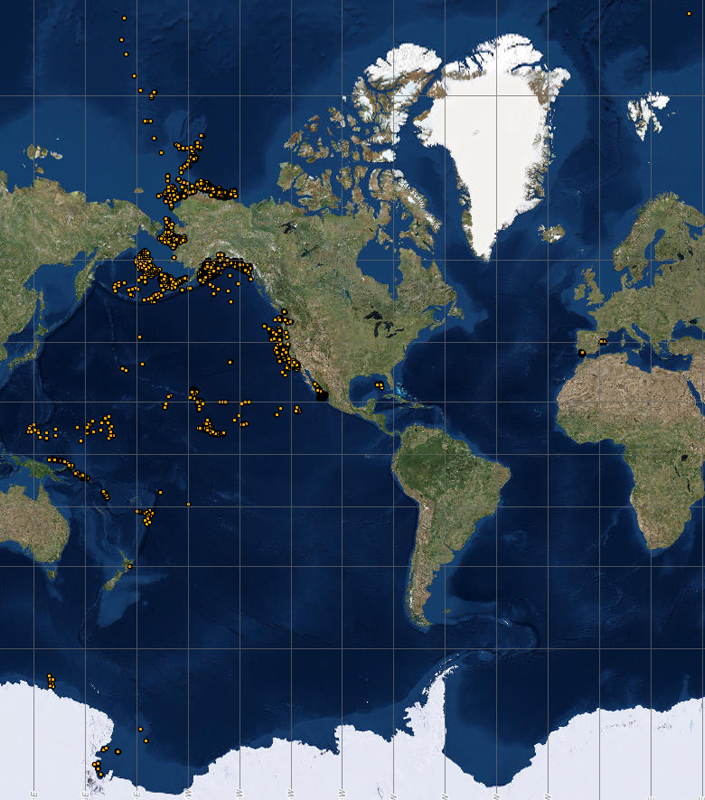 image of sea floor sample locations
The U.S. Geological Survey Coastal and Marine Geology Program (CMGP) Pacific Coastal
and Marine Science Center (PCMSC) Samples Repository is a partner in the Index to
Marine and Lacustrine Geological Samples (IMLGS) database. The Curator sends data
and information related to the PCMSC marine geological sample collection to NCEI to
increase their discoverability via the IMLGS. Selected data, documents, and images
related to the collection are also archived at NCEI and discoverable via the IMLGS,
but the USGS is the authoritative source for all data and information related to USGS
geological samples.
- Cite as: U.S. Geological Survey (USGS) Coastal and Marine Geology Program (CMGP) Pacific Coastal and Marine Science Center (PCMSC). 1977: Archive of Geosample Data and Information from the U.S. Geological Survey (USGS) Coastal and Marine Geology Program (CMGP) Pacific Coastal and Marine Science Center (PCMSC) Samples Repository. NOAA National Centers for Environmental Information. https://doi.org/10.7289/V55T3HGJ. Accessed [date].
- doi:10.7289/V55T3HGJ
- NCEI Metadata ID: gov.noaa.ngdc.mgg.geology:archived-data_USGS-PCMSC-sample-repository
gov.noaa.ngdc.mgg.geology:archived-data_USGS-PCMSC-sample-repository
| Search Data |
|
| Download Data |
|
| Distribution Formats |
|
| Ordering Instructions | Contact NCEI for other distribution options and instructions. |
| Distributor | NOAA National Centers for Environmental Information ncei.info@noaa.gov |
| Dataset Point of Contact | NOAA National Centers for Environmental Information ncei.info@noaa.gov |
| Dataset Point of Contact | Marine Geology Data Manager NOAA National Centers for Environmental Information geology.info@noaa.gov |
| Dataset Point of Contact | U.S. Geological Survey Coastal and Marine Geology Program (CMGP) Pacific Coastal and
Marine Science Center (PCMSC) Samples Repository U.S. Geological Survey Jpadgett@usgs.gov |
| Coverage Description | Global ocean sea floor and lakebeds |
| Time Period | 1969-04-22T00:00:00.000Z to Present |
| Spatial Reference System | urn:ogc:def:crs:EPSG:4326 |
| Spatial Bounding Box Coordinates |
West:-180.00000
East:180.00000
South:-77.03024
North:89.98083
|
| Spatial Coverage Map | |
| General Documentation |
|
| Associated Resources |
|
| Publication Dates |
|
| Data Presentation Form | Digital table - digital representation of facts or figures systematically displayed,
especially in columns |
| Dataset Progress Status | Ongoing - data is continually being updated Historical archive - data has been stored in an offline storage facility |
| Data Update Frequency | Irregular - The repository contributes data to the NCEI archive and to the IMLGS as new samples are added to their collection, as resources allow. |
| Supplemental Information |
Additonal related data and information are available directly from the contributing
institution, which is the authoritative and most current source of data and information
related to their sample collection. The IMLGS contains a subset of summary metadata
from the institutional database. Dr. James Gardner, former Curator of the USGS West
Coast Sample Repository, participated in design of the original IMLGS.
|
| Purpose | Information about USGS marine geosample collections is archived at NCEI to promote public access to research results and to increase their discoverability via the IMLGS. |
| Use Limitations |
|
| Dataset Citation |
|
| Cited Authors |
|
| Originators |
|
| Contributors |
|
| Custodians |
|
| Sponsors |
|
| Publishers |
|
| Acknowledgments |
|
| Theme keywords | Library of Congress Subject Headings
|
| Data Center keywords | Global Change Master Directory (GCMD) Data Center Keywords
|
| Platform keywords | Global Change Master Directory (GCMD) Platform Keywords
|
| Instrument keywords | Global Change Master Directory (GCMD) Instrument Keywords
|
| Place keywords | Global Change Master Directory (GCMD) Location Keywords
|
| Project keywords | Global Change Master Directory (GCMD) Project Keywords
|
| Use Constraints |
|
| Access Constraints |
|
| Other Constraints | Cite as: U.S. Geological Survey (USGS) Coastal and Marine Geology Program (CMGP) Pacific Coastal and Marine Science Center (PCMSC). 1977: Archive of Geosample Data and Information from the U.S. Geological Survey (USGS) Coastal and Marine Geology Program (CMGP) Pacific Coastal and Marine Science Center (PCMSC) Samples Repository. NOAA National Centers for Environmental Information. https://doi.org/10.7289/V55T3HGJ. Accessed [date]. |
| Fees |
|
| Lineage Statement | Data are received by NCEI on an intermittent basis from the repository. Incoming data are checked for adherence to controlled vocabularies, illegal data types in numeric fields, and out of range latitudes/longitudes. NCEI adds IGSNs/links to related resources, where known, and may perform cursory visual inspection of data for reasonableness, asking the originator for guidance on discrepancies. NCEI informs the originator upon ingest of data to the IMLGS database, after which the originator provides one final quality control using the IMLGS map viewer. Data may also be updated/corrected at any time at the originator's request. |
| Processor |
|
| Processing Environment | Native Dataset Environment: database tables with auxiliary text and PDF documents and digital imagery. |
| Source Datasets |
|
| Processing Steps |
|
| Instrument |
|
| Platform |
|
Last Modified: 2022-10-26
For questions about the information on this page, please email:ncei.info@noaa.gov