Archive of Geosample Data and Information from the University of Hawaii at Manoa School of Ocean and Earth Science and Technology (SOEST)
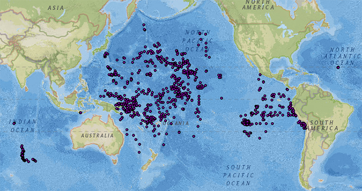 image of sea floor sample locations
The University of Hawaii at Manoa, School of Ocean and Earth Science and Technology
(SOEST) is a partner in the Index to Marine and Lacustrine Geological Samples (IMLGS)
database, contributing information to the IMLGS to help researchers discover geological
samples curated in their facility. The partner repository may also send related data,
documents, and imagery to NCEI for long-term archive, but the originating institution
is the definitive source of information related to their sample collection. The SOEST
dredge repository is under the Department of Geology and Geophysics, the core repository
is under the Department of Oceanography.
- Cite as: University of Hawaii at Manoa, School of Ocean and Earth Science and Technology (SOEST). 1977: Archive of Geosample Data and Information from the University of Hawaii at Manoa School of Ocean and Earth Science and Technology (SOEST). NOAA National Centers for Environmental Information. https://doi.org/10.7289/V50P0X05. Accessed [date].
- doi:10.7289/V50P0X05
- NCEI Metadata ID: gov.noaa.ngdc.mgg.geology:archived-data_SOEST-sample-repository
gov.noaa.ngdc.mgg.geology:archived-data_SOEST-sample-repository
| Search Data |
|
| Download Data |
|
| Distribution Formats |
|
| Ordering Instructions | Contact NCEI for other distribution options and instructions. |
| Distributor | NOAA National Centers for Environmental Information ncei.info@noaa.gov |
| Dataset Point of Contact | NOAA National Centers for Environmental Information ncei.info@noaa.gov |
| Dataset Point of Contact | Marine Geology Data Manager NOAA National Centers for Environmental Information geology.info@noaa.gov |
| Coverage Description | Global ocean sea floor and lakebeds |
| Time Period | 1967-11-08T00:00:00.000Z to Present |
| Spatial Reference System | urn:ogc:def:crs:EPSG:4326 |
| Spatial Bounding Box Coordinates |
West:-179.86700
East:180.0000
South:-46.139
North:48.572
|
| Spatial Coverage Map | |
| General Documentation |
|
| Associated Resources |
|
| Publication Dates |
|
| Data Presentation Form | Digital table - digital representation of facts or figures systematically displayed,
especially in columns |
| Dataset Progress Status | Ongoing - data is continually being updated Historical archive - data has been stored in an offline storage facility |
| Data Update Frequency | Irregular - SOEST has recently begun to contribute data to the NCEI archive and to the IMLGS as they are able to inventory and digitize information about their dredge collection. SOEST core data in the IMLGS were contributed prior to, and have not been updated since approximately 1990. |
| Supplemental Information |
SOEST has an extensive dredge and core collection, primarily from the Pacific Ocean.
Dr. Fritz Theyer, former Curator for the Hawaii Institute of Geophysics, participated
in the design of the original IMLGS.
|
| Purpose | The purpose of adding information about the SOEST geological samples collection to the IMLGS is to promote new research on existing samples. |
| Use Limitations |
|
| Dataset Citation |
|
| Cited Authors |
|
| Originators |
|
| Custodians |
|
| Sponsors |
|
| Publishers |
|
| Acknowledgments |
|
| Theme keywords | Library of Congress Subject Headings
|
| Data Center keywords | Global Change Master Directory (GCMD) Data Center Keywords
|
| Platform keywords | Global Change Master Directory (GCMD) Platform Keywords
|
| Instrument keywords | Global Change Master Directory (GCMD) Instrument Keywords
|
| Place keywords | Global Change Master Directory (GCMD) Location Keywords
|
| Project keywords | Global Change Master Directory (GCMD) Project Keywords
|
| Use Constraints |
|
| Access Constraints |
|
| Other Constraints | Cite as: University of Hawaii at Manoa, School of Ocean and Earth Science and Technology (SOEST). 1977: Archive of Geosample Data and Information from the University of Hawaii at Manoa School of Ocean and Earth Science and Technology (SOEST). NOAA National Centers for Environmental Information. https://doi.org/10.7289/V50P0X05. Accessed [date]. |
| Fees |
|
| Lineage Statement | Data are received by NCEI on an intermittent basis from the repository. Incoming data are checked for adherence to controlled vocabularies, illegal data types in numeric fields, and out of range latitudes/longitudes. NCEI adds IGSNs/links to related resources, where known, and may perform cursory visual inspection of data for reasonableness, asking the originator for guidance on discrepancies. Preliminary processed data are placed in a test database for inspection by the originator, and iteratively corrected until the originator approves their publication to the production database. Data may also be updated/corrected at any time, at the originator's request. |
| Processor |
|
| Processing Environment | Native Dataset Environment: database tables with auxiliary text and PDF documents and digital imagery. |
| Source Datasets |
|
| Processing Steps |
|
| Instrument |
|
| Platform |
|
Last Modified: 2020-04-21
For questions about the information on this page, please email:ncei.info@noaa.gov