Fichier de la Lithotheque Nationale d'Echantillons Marins (BRGM Core Descriptions)
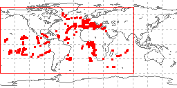 sample locations in study area
In 1975 the BRGM and CNEXO in France joined to create a national marine geological
sampling center at the Centre Oceanologique de Bretagne in Brest. This center collects
and stores samples of the sea bottom and subbottom from all over the world and makes
them available to any person or institution interested in their study. A French national
scientific commission defined the rules for collecting operating and using this facility.
The commission consists of the representatives of the Ministry of Industry, industrial
and oil firms, the main sea ports and Universities as well as of BRGM and CNEXO, which
preside in turn every two years over the commission. BRGM was in charge of the management
of the Center. Not only geological samples but also related data are stored such as
geographical location, depth, weight and number or level, related studies, if any,
etc. (the list of published studies is included). The samples and related data are
identified by computer cards and are stored in computer files. After verification
they are transferred to a data bank which integrates information from the lithotheque,
phototheque and data collections for more complete processing. Institutions and persons
interested in the cores may request the catalog of the already processed samples or
may receive portions of samples for study following approval by the Commission. A
copy of the lithotheque was transmitted to the World Data Center for Marine Geology
and Geophysics, Boulder (now the World Data Service for Geophysics) for distribution
in 1985. More current information is available from BRGM. The data at the WDC include
descriptions of approximately 25,000 samples.
- Cite as: Marthe Melguen. 1985: Fichier de la Lithotheque Nationale d'Echantillons Marins (BRGM Core Descriptions). NOAA National Centers for Environmental Information. Accessed [date].
- ID not available.
gov.noaa.ngdc.mgg.geology:G02898
| Download Data |
|
| Distribution Formats |
|
| Ordering Instructions | Contact NCEI for other distribution options and instructions. |
| Distributor | NOAA National Centers for Environmental Information ncei.info@noaa.gov |
| Dataset Point of Contact | NOAA National Centers for Environmental Information ncei.info@noaa.gov |
| Dataset Point of Contact | Marine Geology Data Manager NOAA National Centers for Environmental Information geology.info@noaa.gov |
| Coverage Description | Global Ocean, mostly Atlantic |
| Time Period | 1985-04-01 to 1985-04-01 |
| Spatial Reference System | urn:ogc:def:crs:EPSG:4326 |
| Spatial Bounding Box Coordinates |
West:-170.397
East:79.007
South:-46.992
North:63.528
|
| Spatial Coverage Map | |
| General Documentation |
|
| Associated Resources |
|
| Publication Dates |
|
| Edition | First |
| Data Presentation Form | Digital table - digital representation of facts or figures systematically displayed,
especially in columns |
| Dataset Progress Status | Complete - production of the data has been completed Historical archive - data has been stored in an offline storage facility |
| Data Update Frequency | Not planned - Completed data set, no additions planned. |
| Supplemental Information |
Please contact the originator for updated information, this is an historic database.
|
| Purpose | environmental research |
| Use Limitations |
|
| Dataset Citation |
|
| Cited Authors |
|
| Publishers |
|
| Acknowledgments |
|
| Theme keywords | Library of Congress Subject Headings
|
| Data Center keywords | Global Change Master Directory (GCMD) Data Center Keywords
|
| Platform keywords | Global Change Master Directory (GCMD) Platform Keywords
|
| Instrument keywords | Global Change Master Directory (GCMD) Instrument Keywords
|
| Place keywords | Global Change Master Directory (GCMD) Location Keywords
|
| Project keywords | Global Change Master Directory (GCMD) Project Keywords
|
| Use Constraints |
|
| Access Constraints |
|
| Other Constraints | Cite as: Marthe Melguen. 1985: Fichier de la Lithotheque Nationale d'Echantillons Marins (BRGM Core Descriptions). NOAA National Centers for Environmental Information. Accessed [date]. |
| Fees |
|
| Lineage Statement | Data were compiled by the Curator at BRGM for possible addition to the Index to Marine and Lacustrine Geological Samples (IMLGS), formerly known as the IMGS. However, the formats were too different for combination at the time the data were contributed, so the data were kept as a separate resource for researchers. |
| Processing Environment | Native Dataset Environment: ASCII text |
| Source Datasets |
| Processing Steps |
|
| Instrument |
|
| Platform |
|
Last Modified: 2020-04-21
For questions about the information on this page, please email:ncei.info@noaa.gov