Index to Marine and Lacustrine Geological Samples (IMLGS)
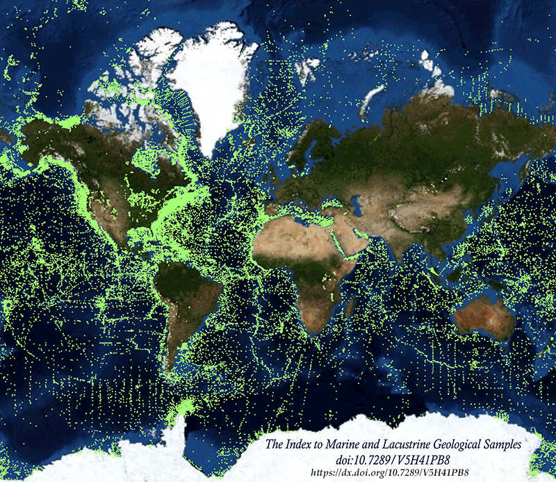 Image of sample locations
The Index to Marine and Lacustrine Geological Samples (IMLGS) product is being decommissioned.
Archived IMLGS data will only be available via an archive request to ncei.info@noaa.gov.
The planned retirement date is May 5th, 2025.
The Index to Marine and Lacustrine Geological Samples (IMLGS) describes and provides access to ocean floor and lakebed rock and sediment samples curated by participating institutional and government repositories in the U.S., Canada, the United Kingdom, France, and Germany. Each curatorial facility prepares and submits data about their own collection to NCEI for inclusion in the IMLGS. NCEI, on behalf of the Curator community, maintains the IMLGS database and a dedicated web application for data discovery and access. Physical material from most samples may be requested from the responsible Curator for scientific research using contact information provided in IMLGS data listings. As of July 2023, the IMLGS includes information for 228,785 discrete seabed and lakebed cores, grabs, dredges, and drill holes worldwide.
Minimum sample information required for the IMLGS includes ship/platform name, cruise ID, sample ID, sampling device, and latitude/longitude. Water depth, collection date, storage method, and principal investigator are usually included. Core dimensions and depth to top and bottom of interval is available for many core samples. Descriptions, comments, physiographic province, lithology, texture, mineralogy, other components, glass remarks, metamorphism information, weathering information, color, and geologic age are included for some samples. An International Generic Sample Number (IGSN) is included, if available. Links are also provided to related data and images at NCEI, partner institutions, and to other sources of information including the System for Earth SAmple Registration (SESAR) and the Rolling Deck to Repository (R2R).
The IMLGS database was initially designed by a group of Curators, in cooperation with NGDC (now NCEI), at a series of meetings sponsored by the U.S. National Science Foundation (NSF) beginning in 1977. The Curators group continues to meet annually to share best practices and oversee the IMLGS database.
- Cite as: Curators of Marine and Lacustrine Geological Samples Consortium. 1977: Index to Marine and Lacustrine Geological Samples (IMLGS). NOAA National Centers for Environmental Information. https://doi.org/10.7289/V5H41PB8. Accessed [date]
- doi:10.7289/V5H41PB8
- NCEI Metadata ID: gov.noaa.ngdc.mgg.geology:G00028
gov.noaa.ngdc.mgg.geology:G00028
| Search Data |
|
| Download Data |
|
| Distribution Formats |
|
| Ordering Instructions | Contact NCEI for other distribution options and instructions. |
| Distributor | NOAA National Centers for Environmental Information ncei.info@noaa.gov |
| Dataset Point of Contact | NOAA National Centers for Environmental Information ncei.info@noaa.gov |
| Dataset Point of Contact | Marine Geology Data Manager NOAA National Centers for Environmental Information geology.info@noaa.gov |
| Coverage Description | Global ocean seabed and lakebeds |
| Time Period | 1885-04-01T00:23:00.000Z to Present |
| Spatial Reference System | urn:ogc:def:crs:EPSG:4326 |
| Spatial Bounding Box Coordinates |
West:-180
East:180
South:-88.367
North:90
|
| Spatial Coverage Map | |
| General Documentation |
|
| Associated Resources |
|
| Publication Dates |
|
| Data Presentation Form | Digital table - digital representation of facts or figures systematically displayed,
especially in columns |
| Dataset Progress Status | Ongoing - data is continually being updated Historical archive - data has been stored in an offline storage facility |
| Data Update Frequency | Irregular - Partner repositories contribute updates as new samples are added to their collections. Some former partner repositories no longer contribute new data. |
| Supplemental Information |
Quality control: Descriptions and metadata are created by the curating facility, which
is responsible for the accuracy of the information. Coded entries are checked on receipt
by the National Centers for Environmental Information for gross errors in coded fields.
|
| Purpose | The purpose of the IMLGS is to promote new research on existing seabed and lakebed cores, grabs, dredges, and drill samples by helping researchers find existing samples curated by participating geosample repositories. Geosamples are invaluable cross-disciplinary resources. Their uses include, but are not limited to, understanding past climate change, assessing benthic habitat for fish and other biological communities, assessing offshore pollution patterns, assessing the impacts of offshore geohazards, determining suitable sites for offshore infrastructure (e.g., wind turbines), finding suitable sediment for coastal restoration, locating strategic offshore mineral resources, ground-truthing acoustic and other remotely-sensed mapping data, and learning more about other Earth systems and processes. |
| Use Limitations |
|
| Dataset Citation |
|
| Cited Authors |
|
| Originators |
|
| Custodians |
|
| Publishers |
|
| Acknowledgments |
|
| Theme keywords | Library of Congress Subject Headings
|
| Data Center keywords | Global Change Master Directory (GCMD) Data Center Keywords
|
| Platform keywords | Global Change Master Directory (GCMD) Platform Keywords
|
| Instrument keywords | Global Change Master Directory (GCMD) Instrument Keywords
|
| Place keywords | Global Change Master Directory (GCMD) Location Keywords
|
| Project keywords | Global Change Master Directory (GCMD) Project Keywords
|
| Use Constraints |
|
| Access Constraints |
|
| Other Constraints | Cite as: Curators of Marine and Lacustrine Geological Samples Consortium. 1977: Index to Marine and Lacustrine Geological Samples (IMLGS). NOAA National Centers for Environmental Information. https://doi.org/10.7289/V5H41PB8. Accessed [date] |
| Fees |
|
| Lineage Statement | Data are received by NCEI on a continuing basis from the participating repositories. Incoming data are checked for adherence to controlled vocabularies, illegal data types in numeric fields, and out of range latitudes/longitudes. NCEI adds IGSNs/links to related resources, where known, and may perform cursory visual inspection of data for reasonableness, asking the originator for guidance on discrepancies. NCEI informs the originator upon ingest of data to the IMLGS database, after which the originator provides one final quality control using the IMLGS map viewer. Data may also be updated/corrected at any time, at the originator's request. |
| Processor |
|
| Processing Environment | Native Dataset Environment: database tables Technical Prerequisites: Contact data center for information |
| Source Datasets |
| Processing Steps |
|
| Instrument |
|
| Platform |
|
Last Modified: 2023-07-13
For questions about the information on this page, please email:ncei.info@noaa.gov