Archive of Geosample Information from the Alfred-Wegener-Institut (AWI) Core Repository

browse graphic
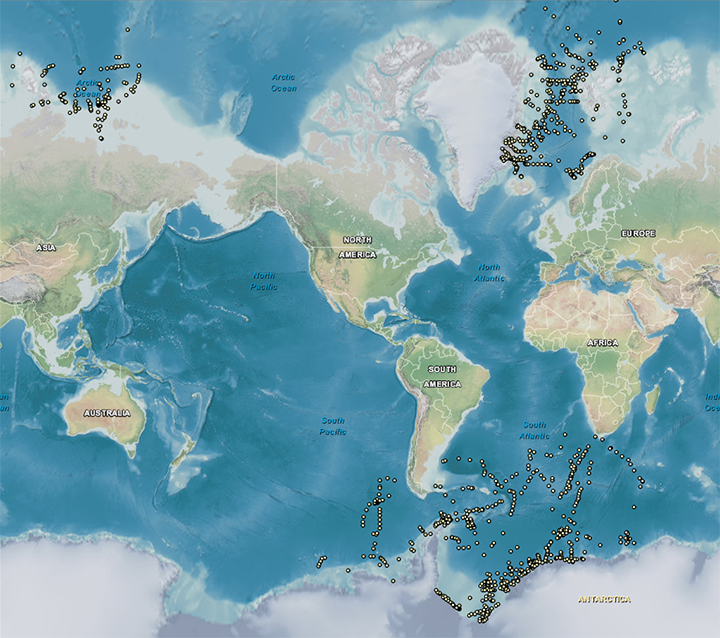
image of sea floor sample locations
The Alfred-Wegener-Institut (AWI) made a one-time contribution to the Index to Marine and Lacustrine Geological Samples (IMLGS) database of metadata describing 1820 piston, gravity, and box cores in their geological sample repository collected during 45 cruises of the Polarstern between February of 1983 and August of 1998. AWI cores described in the IMLGS are from above 60 degrees North Latitude or below 30 degrees South Latitude.
  • Cite as: Alfred-Wegener-Institut (AWI) Core Repository. 1985: Archive of information about the AWI geosample collection. NOAA National Centers for Environmental Information. https://doi.org/doi:10.7289/V5NZ85N8 [date of access].
  • doi:10.7289/V5NZ85N8
  • NCEI Metadata ID: gov.noaa.ngdc.mgg.geology:archived-data_AWI-sample-repository
gov.noaa.ngdc.mgg.geology:archived-data_AWI-sample-repository
Search Data
  • Map viewer (search)
    Open an ArcGIS interactive map interface with the AWI sample layer active, to search and download data from the IMLGS database and access related links.
  • Linked data interface (search)
    Offsite Linked Data interface (RDF graph) for Semantic Web access to the database, offered cooperatively on the Rolling Deck to Repository (R2R) server.
  • Open Data ArcGIS interface (search)
    Access sample information from the IMLGS using the Open Data ArcGIS interface enabling filtering, sorting, and export in multiple formats
Download Data
  • Web forms interface (download)
    Text interface to search and download data for AWI samples from the IMLGS database and access related links.
Distribution Formats
  • ASCII (Version:UTF-8)
    • File Specification: American Standard Code for Information Interchange (ASCII) text format.
  • KML
    • File Specification: Keyhole Markup Language File
Ordering Instructions Contact NCEI for other distribution options and instructions.
Distributor NOAA National Centers for Environmental Information
ncei.info@noaa.gov
Dataset Point of Contact NOAA National Centers for Environmental Information
ncei.info@noaa.gov
Dataset Point of Contact Marine Geology Data Manager
NOAA National Centers for Environmental Information
geology.info@noaa.gov
Coverage Description Global ocean sea floor and lakebeds
Time Period 1983-02-05T00:00:00.000Z to 1998-08-18T00:00:00.000Z
Spatial Reference System urn:ogc:def:crs:EPSG:4326
Spatial Bounding Box Coordinates
West:-176.93
East:159.167
South:-78.254
North:90.0
Spatial Coverage Map
General Documentation
Associated Resources
Publication Dates
  • publication: 1985-12-31
  • revision: 1985-12-31
Data Presentation Form Digital table - digital representation of facts or figures systematically displayed, especially in columns
Dataset Progress Status Complete - production of the data has been completed
Historical archive - data has been stored in an offline storage facility
Data Update Frequency Not planned - AWI data were a one-time contribution to the IMLGS database.
Supplemental Information
The portion of AWI's core collection described in the IMLGS is from polar regions. Additonal related data and information are available directly from the contributing institution, which is the authoritative and most current source of data and information related to their sample collection. The IMLGS contains a subset of summary metadata from the institutional database.
Purpose The purpose of adding information about the AWI geological samples collection to the IMLGS was to promote new research on existing samples.
Use Limitations
  • Produced by the NOAA National Centers for Environmental Information. Not subject to copyright protection within the United States.
Dataset Citation
  • Cite as: Alfred-Wegener-Institut (AWI) Core Repository. 1985: Archive of information about the AWI geosample collection. NOAA National Centers for Environmental Information. https://doi.org/doi:10.7289/V5NZ85N8 [date of access].
Cited Authors
  • Alfred-Wegener-Institut (AWI) Core Repository
Originators
  • Dr. Hannes Grobe
    Alfred-Wegener-Institut, Core Repository
Custodians
  • NOAA National Centers for Environmental Information
Publishers
  • NOAA National Centers for Environmental Information
Acknowledgments
  • Complete data about the AWI sample collection is maintained by PANGAEA.
Theme keywords Library of Congress Subject Headings
  • Databases
  • Scientific archives
  • Electronic records
  • Oceanography
  • Ocean bottom
  • Geology
  • Submarine geology
SeaDataNet Common Vocabularies
  • Marine geology
USGS Science Topics
  • Sea-floor characteristics
Data Center keywords Global Change Master Directory (GCMD) Data Center Keywords
  • DOC/NOAA/NESDIS/NCEI > National Centers for Environmental Information, NESDIS, NOAA, U.S. Department of Commerce
  • DOC/NOAA/NESDIS/NGDC > National Geophysical Data Center, NESDIS, NOAA, U.S. Department of Commerce
Platform keywords Global Change Master Directory (GCMD) Platform Keywords
  • In Situ Ocean-based Platforms > SHIPS
Instrument keywords Global Change Master Directory (GCMD) Instrument Keywords
  • In Situ/Laboratory Instruments > Corers > CORING DEVICES
Place keywords Global Change Master Directory (GCMD) Location Keywords
  • GEOGRAPHIC REGION > GLOBAL OCEAN
  • VERTICAL LOCATION > SEA FLOOR
  • OCEAN > ATLANTIC OCEAN
  • OCEAN > ARCTIC OCEAN
  • OCEAN > SOUTHERN OCEAN
Project keywords Global Change Master Directory (GCMD) Project Keywords
  • IMLGS
Global Change Master Directory (GCMD) Project Keywords
  • ICSU-WDS > International Council for Science - World Data System
Use Constraints
  • Use liability: NOAA and NCEI cannot provide any warranty as to the accuracy, reliability, or completeness of furnished data. Users assume responsibility to determine the usability of these data. The user is responsible for the results of any application of this data for other than its intended purpose.
  • Please consult the Curator before proposing to do research on any sample discovered through the IMLGS or the NCEI archive.
  • While every effort has been made to ensure that these data are accurate and reliable within the limits of the current state of the art, NOAA cannot assume liability for any damages caused by any errors or omissions in the data, nor as a result of the failure of the data to function on a particular system. NOAA makes no warranty, expressed or implied, nor does the fact of distribution constitute such a warranty.
Access Constraints
  • Distribution liability: NOAA and NCEI make no warranty, expressed or implied, regarding these data, nor does the fact of distribution constitute such a warranty. NOAA and NCEI cannot assume liability for any damages caused by any errors or omissions in these data. If appropriate, NCEI can only certify that the data it distributes are an authentic copy of the records that were accepted for inclusion in the NCEI archives.
  • Sample metadata are available online for free download.
Other Constraints Cite as: Alfred-Wegener-Institut (AWI) Core Repository. 1985: Archive of information about the AWI geosample collection. NOAA National Centers for Environmental Information. https://doi.org/doi:10.7289/V5NZ85N8 [date of access].
Fees
  • In most cases, electronic downloads of the data are free. However, fees may apply for custom orders, data certifications, copies of analog materials, and data distribution on physical media.
Lineage information for:dataset
Lineage Statement Data were a one-time contribution from this repository. Incoming data were checked for adherence to controlled vocabularies, illegal data types in numeric fields, and out of range latitudes/longitudes. NCEI performed cursory visual inspection of data for reasonableness, asking the originator for guidance on discrepancies.
Processor
  • NOAA National Centers for Environmental Information
Processing Environment Native Dataset Environment: database tables.
Source Datasets
  • AWI reports and publications
    • Description of Source: Additional information about the samples may be contained in AWI technical reports and/or publications.
Lineage information for:repository
Processing Steps
  • 2015-04-22T00:00:00 -NOAA created the National Centers for Environmental Information (NCEI) by merging NOAA's National Climatic Data Center (NCDC), National Geophysical Data Center (NGDC), and National Oceanographic Data Center (NODC), including the National Coastal Data Development Center (NCDDC), per the Consolidated and Further Continuing Appropriations Act, 2015, Public Law 113-235. NCEI launched publicly on April 22, 2015.
Acquisition Information (collection)
Instrument
  • In Situ/Laboratory Instruments
  • In Situ/Laboratory Instruments
Platform
    Last Modified: 2020-04-21
    For questions about the information on this page, please email:ncei.info@noaa.gov