| Multibeam Bathymetry Database (MBBDB) | spatialRepresentationInfo|
|---|---|
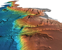
| а(MI_Metadata) ааааfileIdentifier: аgov.noaa.ngdc:G01034 ааааhierarchyLevel: а(MD_ScopeCode)аseries ааааcontact: а(CI_ResponsibleParty) ааааааааorganisationName: аNOAA National Centers for Environmental Information ааааааааcontactInfo: а(CI_Contact) ааааааааааааaddress: а(CI_Address) ааааааааааааааааelectronicMailAddress: аncei.info@noaa.gov ааааааааааааonlineResource: а(CI_OnlineResource) ааааааааааааааааlinkage: https://www.ncei.noaa.gov/contact ааааааааааааааааname: аNCEI Contact Information ааааааааааааааааdescription: аInformation for contacts at NCEI. ааааааааааааааааfunction: а(CI_OnLineFunctionCode)аinformation ааааааааrole: а(CI_RoleCode)аpointOfContact ааааdateStamp: а2023-09-15 ааааmetadataStandardName: аISO 19115-2 Geographic Information - Metadata - Part 2: Extensions for Imagery and Gridded Data ааааmetadataStandardVersion: аISO 19115-2:2009(E) return to top ааааspatialRepresentationInfo: а(MD_VectorSpatialRepresentation) ааааааааgeometricObjects: а(MD_GeometricObjects) ааааааааааааgeometricObjectType: а(MD_GeometricObjectTypeCode)аpoint return to top ааааreferenceSystemInfo: а(MD_ReferenceSystem) ааааааааreferenceSystemIdentifier: а(RS_Identifier) ааааааааааааauthority: (inapplicable) ааааааааааааcode: аThrough the collection reference systems have vaired with time and location. Please see survey level metadata for detailed information. return to top ааааidentificationInfo: а(MD_DataIdentification) ааааааааcitation: а(CI_Citation) ааааааааааааtitle: аMultibeam Bathymetry Database (MBBDB) ааааааааааааdate: а(CI_Date) ааааааааааааааааdate: а1980 ааааааааааааааааdateType: а(CI_DateTypeCode)аcreation ааааааааааааdate: а(CI_Date) ааааааааааааааааdate: а2023 ааааааааааааааааdateType: а(CI_DateTypeCode)аrevision ааааааааааааdate: а(CI_Date) ааааааааааааааааdate: а2023-09-15 ааааааааааааааааdateType: а(CI_DateTypeCode)аpublication ааааааааааааidentifier: а(MD_Identifier) ааааааааааааааааauthority: а(CI_Citation) ааааааааааааааааааааtitle: аInternational DOI Foundation (IDF) ааааааааааааааааааааdate: (inapplicable) ааааааааааааааааcode: ааааааааааааааааааAnchor: аDOIаdoi:10.7289/V56T0JNC ааааааааааааidentifier: а(MD_Identifier) ааааааааааааааааauthority: а(CI_Citation) ааааааааааааааааааааtitle: аNOAA National Centers for Environmental Information ааааааааааааааааааааdate: (inapplicable) ааааааааааааааааcode: аNCEI Metadata ID: gov.noaa.ngdc:G01034 ааааааааааааcitedResponsibleParty: а(CI_ResponsibleParty) ааааааааааааааааorganisationName: аNOAA National Centers for Environmental Information ааааааааааааааааrole: а(CI_RoleCode)аauthor ааааааааааааcitedResponsibleParty: а(CI_ResponsibleParty) ааааааааааааааааorganisationName: аNOAA National Centers for Environmental Information ааааааааааааааааrole: а(CI_RoleCode)аpublisher ааааааааааааotherCitationDetails: аThe Multibeam Bathymetry Database went online in 2004 ааааааааabstract: аOriginally designed for military use, the multibeam echosounder has proved very useful for nautical charting, oceanographic research and modeling, habitat classification, maritime commerce, and recreational applications. The Multibeam Bathymetry Database at NCEI collects and archives multibeam data from the earliest commercial installations (circa 1980) through today's modern high-resolution collections. Data are acquired from a variety of primarily government and academic sources (see individual cruise metadata records for source information) and consist of the raw (as collected) sonar data files. Datasets may also include processed or edited versions of the sonar data, ancillary data, derived products, and/or metadata for the data collection. The Multibeam Bathymetry Database provides data that span the globe and are discoverable and accesible via map interface or text-only search options. ааааааааpurpose: аNGDC (now NCEI) established the Multibeam Bathymetry Database to provide a comprehensive database of multibeam bathymetric data on a global scale. The intent of the dataset is to make high-resolution bathymetry available to the public for a wide variety of uses, such as research and earth science analysis. These data are NOT to be used for navigation. ааааааааstatus: а(MD_ProgressCode)аinProgress ааааааааstatus: а(MD_ProgressCode)аhistoricalArchive ааааааааpointOfContact: а(CI_ResponsibleParty) ааааааааааааorganisationName: аNOAA National Centers for Environmental Information ааааааааааааcontactInfo: а(CI_Contact) ааааааааааааааааaddress: а(CI_Address) ааааааааааааааааааааelectronicMailAddress: аncei.info@noaa.gov ааааааааааааааааonlineResource: а(CI_OnlineResource) ааааааааааааааааааааlinkage: https://www.ncei.noaa.gov/contact ааааааааааааааааааааname: аNCEI Contact Information ааааааааааааааааааааdescription: аInformation for contacts at NCEI. ааааааааааааааааааааfunction: а(CI_OnLineFunctionCode)аinformation ааааааааааааrole: а(CI_RoleCode)аpointOfContact ааааааааpointOfContact: а(CI_ResponsibleParty) ааааааааааааorganisationName: аNOAA National Centers for Environmental Information ааааааааааааpositionName: аMultibeam Data Manager ааааааааааааcontactInfo: а(CI_Contact) ааааааааааааааааphone: а(CI_Telephone) ааааааааааааааааааааvoice: а(303) 497-4613 ааааааааааааааааааааfacsimile: а(303) 497-6513 ааааааааааааааааaddress: а(CI_Address) ааааааааааааааааааааelectronicMailAddress: аmb.info@noaa.gov ааааааааааааааааhoursOfService: а8:00 - 4:30 Mountain ааааааааааааrole: а(CI_RoleCode)аpointOfContact ааааааааresourceMaintenance: а(MD_MaintenanceInformation) ааааааааааааmaintenanceAndUpdateFrequency: а(MD_MaintenanceFrequencyCode)аasNeeded ааааааааааааmaintenanceNote: аUpdated as needed ааааааааgraphicOverview: а(MD_BrowseGraphic) ааааааааааааfileName: https://ngdc.noaa.gov/mgg/image/multibeam.gif ааааааааааааfileDescription: а1996: Dr. Lincoln Pratson, INSTAAR/NGDC offshore California gridded multibeam data ааааааааааааfileType: аgif ааааааааdescriptiveKeywords: а(MD_Keywords) ааааааааааааkeyword: аNGDA ааааааааааааkeyword: аNational Geospatial Data Asset ааааааааааааkeyword: аElevation Theme ааааааааааааtype: а(MD_KeywordTypeCode)аtheme ааааааааааааthesaurusName: а(CI_Citation) ааааааааааааааааtitle: аNGDA Portfolio Themes ааааааааааааааааdate: (unknown) ааааааааdescriptiveKeywords: а(MD_Keywords) ааааааааааааkeyword: аEarth Science > Oceans > Bathymetry/Seafloor Topography > Abyssal Hills/Plains ааааааааааааkeyword: аEarth Science > Oceans > Bathymetry/Seafloor Topography > Bathymetry ааааааааааааkeyword: аEarth Science > Oceans > Bathymetry/Seafloor Topography > Continental Margins ааааааааааааkeyword: аEarth Science > Oceans > Bathymetry/Seafloor Topography > Fracture Zones ааааааааааааkeyword: аEarth Science > Oceans > Bathymetry/Seafloor Topography > Ocean Plateaus/Ridges ааааааааааааkeyword: аEarth Science > Oceans > Bathymetry/Seafloor Topography > Seafloor Topography ааааааааааааkeyword: аEarth Science > Oceans > Bathymetry/Seafloor Topography > Seamounts ааааааааааааkeyword: аEarth Science > Oceans > Bathymetry/Seafloor Topography > Submarine Canyons ааааааааааааkeyword: аEarth Science > Oceans > Bathymetry/Seafloor Topography > Trenches ааааааааааааkeyword: аEarth Science > Oceans > Bathymetry/Seafloor Topography > Water Depth ааааааааааааtype: а(MD_KeywordTypeCode)аtheme ааааааааааааthesaurusName: а(CI_Citation) ааааааааааааааааtitle: аGlobal Change Master Directory (GCMD) Science Keywords ааааааааааааааааdate: а(CI_Date) ааааааааааааааааааааdate: а2020-01-09 ааааааааааааааааааааdateType: а(CI_DateTypeCode)аpublication ааааааааааааааааedition: а9.1 ааааааааааааааааcitedResponsibleParty: а(CI_ResponsibleParty) ааааааааааааааааааааorganisationName: аNASA Goddard Space Flight Center, Earth Science Data and Information System ааааааааааааааааааааcontactInfo: а(CI_Contact) ааааааааааааааааааааааааonlineResource: а(CI_OnlineResource) ааааааааааааааааааааааааааааlinkage: https://www.earthdata.nasa.gov/learn/find-data/idn/gcmd-keywords ааааааааааааааааааааааааааааname: аGlobal Change Master Directory (GCMD) Keywords ааааааааааааааааааааааааааааdescription: аThe information provided on this page seeks to define how the GCMD Keywords are structured, used and accessed. It also provides information on how users can participate in the further development of the keywords. ааааааааааааааааааааааааааааfunction: а(CI_OnLineFunctionCode)аinformation ааааааааааааааааааааrole: а(CI_RoleCode)аcustodian ааааааааdescriptiveKeywords: а(MD_Keywords) ааааааааааааkeyword: аICSU-WDS > International Council for Science - World Data System ааааааааааааtype: а(MD_KeywordTypeCode)аproject ааааааааааааthesaurusName: а(CI_Citation) ааааааааааааааааtitle: аGlobal Change Master Directory (GCMD) Project Keywords ааааааааааааааааdate: а(CI_Date) ааааааааааааааааааааdate: а2020-01-09 ааааааааааааааааааааdateType: а(CI_DateTypeCode)аpublication ааааааааааааааааedition: а9.1 ааааааааааааааааcitedResponsibleParty: а(CI_ResponsibleParty) ааааааааааааааааааааorganisationName: аNASA Goddard Space Flight Center, Earth Science Data and Information System ааааааааааааааааааааcontactInfo: а(CI_Contact) ааааааааааааааааааааааааonlineResource: а(CI_OnlineResource) ааааааааааааааааааааааааааааlinkage: https://www.earthdata.nasa.gov/learn/find-data/idn/gcmd-keywords ааааааааааааааааааааааааааааname: аGlobal Change Master Directory (GCMD) Keywords ааааааааааааааааааааааааааааdescription: аThe information provided on this page seeks to define how the GCMD Keywords are structured, used and accessed. It also provides information on how users can participate in the further development of the keywords. ааааааааааааааааааааааааааааfunction: а(CI_OnLineFunctionCode)аinformation ааааааааааааааааааааrole: а(CI_RoleCode)аcustodian ааааааааdescriptiveKeywords: а(MD_Keywords) ааааааааааааkeyword: аGlobal Ocean ааааааааааааkeyword: аSea Floor ааааааааааааtype: а(MD_KeywordTypeCode)аplace ааааааааааааthesaurusName: а(CI_Citation) ааааааааааааааааtitle: аGlobal Change Master Directory (GCMD) Location Keywords ааааааааааааааааdate: а(CI_Date) ааааааааааааааааааааdate: а2020-01-09 ааааааааааааааааааааdateType: а(CI_DateTypeCode)аpublication ааааааааааааааааedition: а9.1 ааааааааааааааааcitedResponsibleParty: а(CI_ResponsibleParty) ааааааааааааааааааааorganisationName: аNASA Goddard Space Flight Center, Earth Science Data and Information System ааааааааааааааааааааcontactInfo: а(CI_Contact) ааааааааааааааааааааааааonlineResource: а(CI_OnlineResource) ааааааааааааааааааааааааааааlinkage: https://www.earthdata.nasa.gov/learn/find-data/idn/gcmd-keywords ааааааааааааааааааааааааааааname: аGlobal Change Master Directory (GCMD) Keywords ааааааааааааааааааааааааааааdescription: аThe information provided on this page seeks to define how the GCMD Keywords are structured, used and accessed. It also provides information on how users can participate in the further development of the keywords. ааааааааааааааааааааааааааааfunction: а(CI_OnLineFunctionCode)аinformation ааааааааааааааааааааrole: а(CI_RoleCode)аcustodian ааааааааdescriptiveKeywords: а(MD_Keywords) ааааааааааааkeyword: аDOC/NOAA/NESDIS/NCEI > National Centers for Environmental Information, NESDIS, NOAA, U.S. Department of Commerce ааааааааааааkeyword: аDOC/NOAA/NESDIS/NGDC > National Geophysical Data Center, NESDIS, NOAA, U.S. Department of Commerce ааааааааааааtype: а(MD_KeywordTypeCode)аdataCentre ааааааааааааthesaurusName: а(CI_Citation) ааааааааааааааааtitle: аGlobal Change Master Directory (GCMD) Data Center Keywords ааааааааааааааааdate: а(CI_Date) ааааааааааааааааааааdate: а2020-01-09 ааааааааааааааааааааdateType: а(CI_DateTypeCode)аpublication ааааааааааааааааedition: а9.1 ааааааааааааааааcitedResponsibleParty: а(CI_ResponsibleParty) ааааааааааааааааааааorganisationName: аNASA Goddard Space Flight Center, Earth Science Data and Information System ааааааааааааааааааааcontactInfo: а(CI_Contact) ааааааааааааааааааааааааonlineResource: а(CI_OnlineResource) ааааааааааааааааааааааааааааlinkage: https://www.earthdata.nasa.gov/learn/find-data/idn/gcmd-keywords ааааааааааааааааааааааааааааname: аGlobal Change Master Directory (GCMD) Keywords ааааааааааааааааааааааааааааdescription: аThe information provided on this page seeks to define how the GCMD Keywords are structured, used and accessed. It also provides information on how users can participate in the further development of the keywords. ааааааааааааааааааааааааааааfunction: а(CI_OnLineFunctionCode)аinformation ааааааааааааааааааааrole: а(CI_RoleCode)аcustodian ааааааааdescriptiveKeywords: а(MD_Keywords) ааааааааааааkeyword: аDOC/NOAA/NESDIS/NCEI > National Centers for Environmental Information, NESDIS, NOAA, U.S. Department of Commerce ааааааааааааtype: а(MD_KeywordTypeCode)аdataCentre ааааааааааааthesaurusName: а(CI_Citation) ааааааааааааааааtitle: аGlobal Change Master Directory (GCMD) Data Center Keywords ааааааааааааааааdate: а(CI_Date) ааааааааааааааааааааdate: а2020-01-09 ааааааааааааааааааааdateType: а(CI_DateTypeCode)аpublication ааааааааааааааааedition: а9.1 ааааааааааааааааcitedResponsibleParty: а(CI_ResponsibleParty) ааааааааааааааааааааorganisationName: аNASA Goddard Space Flight Center, Earth Science Data and Information System ааааааааааааааааааааcontactInfo: а(CI_Contact) ааааааааааааааааааааааааonlineResource: а(CI_OnlineResource) ааааааааааааааааааааааааааааlinkage: https://www.earthdata.nasa.gov/learn/find-data/idn/gcmd-keywords ааааааааааааааааааааааааааааname: аGlobal Change Master Directory (GCMD) Keywords ааааааааааааааааааааааааааааdescription: аThe information provided on this page seeks to define how the GCMD Keywords are structured, used and accessed. It also provides information on how users can participate in the further development of the keywords. ааааааааааааааааааааааааааааfunction: а(CI_OnLineFunctionCode)аinformation ааааааааааааааааааааrole: а(CI_RoleCode)аcustodian ааааааааresourceConstraints: а(MD_LegalConstraints) ааааааааааааaccessConstraints: а(MD_RestrictionCode)аotherRestrictions ааааааааааааotherConstraints: аDistribution liability: NOAA and NCEI make no warranty, expressed or implied, regarding these data, nor does the fact of distribution constitute such a warranty. NOAA and NCEI cannot assume liability for any damages caused by any errors or omissions in these data. If appropriate, NCEI can only certify that the data it distributes are an authentic copy of the records that were accepted for inclusion in the NCEI archives. ааааааааresourceConstraints: а(MD_LegalConstraints) ааааааааааааuseConstraints: а(MD_RestrictionCode)аotherRestrictions ааааааааааааotherConstraints: аUse liability: NOAA and NCEI cannot provide any warranty as to the accuracy, reliability, or completeness of furnished data. Users assume responsibility to determine the usability of these data. The user is responsible for the results of any application of this data for other than its intended purpose. ааааааааresourceConstraints: а(MD_LegalConstraints) ааааааааааааuseConstraints: а(MD_RestrictionCode)аotherRestrictions ааааааааааааotherConstraints: аCite as: NOAA National Centers for Environmental Information. 2004: Multibeam Bathymetry Database (MBBDB). [cruise]. NOAA National Centers for Environmental Information. https://doi.org/doi:10.7289/V56T0JNC. Accessed [date]. ааааааааresourceConstraints: а(MD_LegalConstraints) ааааааааааааuseConstraints: а(MD_RestrictionCode)аotherRestrictions ааааааааааааotherConstraints: аData shall NOT be used for navigation. Nautical charts produced and certified by NOAA should be used for navigational purposes. For more information on NOAA's nautical charts go to NOAA's Office of Coast Survey website. ааааааааresourceConstraints: а(MD_LegalConstraints) ааааааааааааaccessConstraints: а(MD_RestrictionCode)аotherRestrictions ааааааааааааotherConstraints: аData are publicly available and free to use. ааааааааaggregationInfo: а(MD_AggregateInformation) ааааааааааааaggregateDataSetName: а(CI_Citation) ааааааааааааааааtitle: аMultibeam Bathymetric Data at NOAA/NGDC ааааааааааааааааdate: а(CI_Date) ааааааааааааааааааааdate: а2020-12-01 ааааааааааааааааааааdateType: а(CI_DateTypeCode)аpublication ааааааааааааааааcitedResponsibleParty: а(CI_ResponsibleParty) ааааааааааааааааааааorganisationName: аVirden, W. ааааааааааааааааааааrole: а(CI_RoleCode)аoriginator ааааааааааааааааcitedResponsibleParty: а(CI_ResponsibleParty) ааааааааааааааааааааorganisationName: аHabermann, T. ааааааааааааааааааааrole: а(CI_RoleCode)аoriginator ааааааааааааааааcitedResponsibleParty: а(CI_ResponsibleParty) ааааааааааааааааааааorganisationName: аGlover, G. ааааааааааааааааааааrole: а(CI_RoleCode)аoriginator ааааааааааааааааcitedResponsibleParty: а(CI_ResponsibleParty) ааааааааааааааааааааorganisationName: аDivins, D. ааааааааааааааааааааrole: а(CI_RoleCode)аoriginator ааааааааааааааааcitedResponsibleParty: а(CI_ResponsibleParty) ааааааааааааааааааааorganisationName: аSharman, G. ааааааааааааааааааааrole: а(CI_RoleCode)аoriginator ааааааааааааааааcitedResponsibleParty: а(CI_ResponsibleParty) ааааааааааааааааааааorganisationName: аFox, C. ааааааааааааааааааааrole: а(CI_RoleCode)аoriginator ааааааааааааааааseries: а(CI_Series) ааааааааааааааааааааname: аBridges Across the Ocean ааааааааааааааааааааissueIdentification: аOCEANS'04 MTS/IEEE, TECHNO-OCEAN'04 November 9-12, 2004 (conference) ааааааааааааassociationType: а(DS_AssociationTypeCode)аcrossReference ааааааааааааinitiativeType: а(DS_InitiativeTypeCode)аsciencePaper ааааааааspatialRepresentationType: а(MD_SpatialRepresentationTypeCode)аvector ааааааааlanguage: аeng; USA ааааааааtopicCategory: а(MD_TopicCategoryCode)аoceans ааааааааtopicCategory: а(MD_TopicCategoryCode)аelevation ааааааааextent: а(EX_Extent) ааааааааааааgeographicElement: а(EX_GeographicBoundingBox) ааааааааааааааааwestBoundLongitude: а-180 ааааааааааааааааeastBoundLongitude: а180 ааааааааааааааааsouthBoundLatitude: а-90 ааааааааааааааааnorthBoundLatitude: а90 ааааааааааааtemporalElement: а(EX_TemporalExtent) ааааааааааааааааextent: ааааааааааааааааааTimePeriod: ааааааааааааааааааааbeginPosition: а1980-01-01 ааааааааааааааааааааendPosition: return to top ааааidentificationInfo: а(SV_ServiceIdentification) ааааааааcitation: а(CI_Citation) ааааааааааааtitle: аMultibeam Bathymetric Surveys ArcGIS Map Service ааааааааааааdate: а(CI_Date) ааааааааааааааааdate: а2012-01-01 ааааааааааааааааdateType: а(CI_DateTypeCode)аcreation ааааааааааааcitedResponsibleParty: а(CI_ResponsibleParty) ааааааааааааааааorganisationName: аDOC/NOAA/NESDIS/NCEI > National Centers for Environmental Information, NESDIS, NOAA, Department of Commerce ааааааааааааааааcontactInfo: а(CI_Contact) ааааааааааааааааааааonlineResource: а(CI_OnlineResource) ааааааааааааааааааааааааlinkage: https://ngdc.noaa.gov/mgg/bathymetry/multibeam.html ааааааааааааааааааааааааname: аMultibeam Bathymetric Data at NCEI ааааааааааааааааааааааааdescription: аPlease see website for more information about Multibeam Bathymetric Data. Test ааааааааааааааааааааааааfunction: а(CI_OnLineFunctionCode)аinformation ааааааааааааааааrole: а(CI_RoleCode)аpublisher ааааааааааааcitedResponsibleParty: а(CI_ResponsibleParty) ааааааааааааааааorganisationName: аDOC/NOAA/NESDIS/NCEI > National Centers for Environmental Information, NESDIS, NOAA, Department of Commerce ааааааааааааааааcontactInfo: а(CI_Contact) ааааааааааааааааааааonlineResource: а(CI_OnlineResource) ааааааааааааааааааааааааlinkage: https://noaa.maps.arcgis.com/home/item.html?id=db08517a205b48c98a9bc53fece67a46 ааааааааааааааааааааааааname: аNOAA GeoPlatform Entry for Multibeam Bathymetric Surveys ааааааааааааааааааааааааdescription: аNOAA GeoPlatform listing for Multibeam Bathymetric Surveys map service. ааааааааааааааааааааааааfunction: а(CI_OnLineFunctionCode)аinformation ааааааааааааааааrole: а(CI_RoleCode)аpublisher ааааааааabstract: аThis map service shows ship tracks for multibeam bathymetric surveys archived at NCEI. Attributes are available such as platform name, survey start/end dates, source organization, and links to metadata and data download pages. ааааааааpointOfContact: а(CI_ResponsibleParty) ааааааааааааindividualName: аNCEI GIS Team ааааааааааааorganisationName: аNOAA National Centers for Environmental Information ааааааааааааcontactInfo: а(CI_Contact) ааааааааааааааааaddress: а(CI_Address) ааааааааааааааааааааelectronicMailAddress: аncei.gis@noaa.gov ааааааааааааrole: а(CI_RoleCode)аpointOfContact ааааааааdescriptiveKeywords: а(MD_Keywords) ааааааааааааkeyword: аData Analysis and Visualization > Geographic Information Systems > Web-Based Geographic Information Systems ааааааааааааkeyword: аData Management/Data Handling > Data Search and Retrival ааааааааааааkeyword: аData Analysis and Visualization > Visualization/Image Processing ааааааааааааtype: а(MD_KeywordTypeCode)аtheme ааааааааааааthesaurusName: а(CI_Citation) ааааааааааааааааtitle: аGlobal Change Master Directory (GCMD) Service Keywords ааааааааааааааааdate: а(CI_Date) ааааааааааааааааааааdate: а2020-01-09 ааааааааааааааааааааdateType: а(CI_DateTypeCode)аpublication ааааааааааааааааedition: а9.1 ааааааааааааааааcitedResponsibleParty: а(CI_ResponsibleParty) ааааааааааааааааааааorganisationName: аNASA Goddard Space Flight Center, Earth Science Data and Information System ааааааааааааааааааааcontactInfo: а(CI_Contact) ааааааааааааааааааааааааonlineResource: а(CI_OnlineResource) ааааааааааааааааааааааааааааlinkage: https://www.earthdata.nasa.gov/learn/find-data/idn/gcmd-keywords ааааааааааааааааааааааааааааname: аGlobal Change Master Directory (GCMD) Keywords ааааааааааааааааааааааааааааdescription: аThe information provided on this page seeks to define how the GCMD Keywords are structured, used and accessed. It also provides information on how users can participate in the further development of the keywords. ааааааааааааааааааааааааааааfunction: а(CI_OnLineFunctionCode)аinformation ааааааааааааааааааааrole: а(CI_RoleCode)аcustodian ааааааааresourceConstraints: а(MD_Constraints) ааааааааааааuseLimitation: аNone ааааааааааааuseLimitation: аNone ааааааааserviceType: ааааааааааLocalName: аArcGIS Map Service ааааааааserviceTypeVersion: а10.7 ааааааааextent: а(EX_Extent) ааааааааааааgeographicElement: а(EX_GeographicBoundingBox) ааааааааааааааааextentTypeCode: а1 ааааааааааааааааwestBoundLongitude: а-180 ааааааааааааааааeastBoundLongitude: а180 ааааааааааааааааsouthBoundLatitude: а-90 ааааааааааааааааnorthBoundLatitude: а90 ааааааааcouplingType: а(SV_CouplingType)аtight ааааааааcontainsOperations: а(SV_OperationMetadata) ааааааааааааoperationName: аArcGIS for Server REST endpoint for hosted tile layer ааааааааааааDCP: (unknown) ааааааааааааconnectPoint: а(CI_OnlineResource) ааааааааааааааааlinkage: https://tiles.arcgis.com/tiles/C8EMgrsFcRFL6LrL/arcgis/rest/services/multibeam_tracklines/MapServer ааааааааааааааааprotocol: аhttps ааааааааааааааааapplicationProfile: https://www.geoplatform.gov/spec/esri-map-rest ааааааааааааааааname: аMultibeam Bathymetric Surveys ArcGIS Hosted Tile Layer ааааааааааааааааdescription: аThe Multibeam Bathymetric Surveys ArcGIS hosted tile layer provides rapid display of ship tracks from global scales to zoom level 10 (approx. 1:577,000 scale). ааааааааааааааааfunction: а(CI_OnLineFunctionCode)аsearch ааааааааcontainsOperations: а(SV_OperationMetadata) ааааааааааааoperationName: аArcGIS for Server REST endpoint for dynamic map service ааааааааааааDCP: (unknown) ааааааааааааconnectPoint: а(CI_OnlineResource) ааааааааааааааааlinkage: https://gis.ngdc.noaa.gov/arcgis/rest/services/web_mercator/multibeam_dynamic/MapServer ааааааааааааааааprotocol: аhttps ааааааааааааааааapplicationProfile: https://www.geoplatform.gov/spec/esri-map-rest ааааааааааааааааname: аMultibeam Bathymetric Surveys ArcGIS Dynamic Map Service ааааааааааааааааdescription: аThe Multibeam Bathymetric Surveys ArcGIS dynamic map service is visible at all scales, and a filter can be applied using the layerDefinitions parameter. ааааааааааааааааfunction: а(CI_OnLineFunctionCode)аsearch ааааааааcontainsOperations: а(SV_OperationMetadata) ааааааааааааoperationName: аWMS Get Capabilities ааааааааааааDCP: ааааааааааааconnectPoint: а(CI_OnlineResource) ааааааааааааааааlinkage: https://gis.ngdc.noaa.gov/arcgis/services/web_mercator/multibeam_dynamic/MapServer/WMSServer?request=GetCapabilities&service=WMS ааааааааааааааааprotocol: аhttps ааааааааааааааааapplicationProfile: https://opengis.net/spec/wms ааааааааааааааааname: аMultibeam Bathymetric Surveys Web Map Service (WMS) ааааааааааааааааdescription: аCapabilities document for Open Geospatial Consortium Web Map Service for Multibeam Bathymetric Surveys ааааааааааааааааfunction: а(CI_OnLineFunctionCode)аsearch return to top ааааdistributionInfo: а(MD_Distribution) ааааааааdistributor: а(MD_Distributor) ааааааааааааdistributorContact: а(CI_ResponsibleParty) ааааааааааааааааorganisationName: аNOAA National Centers for Environmental Information ааааааааааааааааcontactInfo: а(CI_Contact) ааааааааааааааааааааaddress: а(CI_Address) ааааааааааааааааааааааааelectronicMailAddress: аncei.info@noaa.gov ааааааааааааааааааааonlineResource: а(CI_OnlineResource) ааааааааааааааааааааааааlinkage: https://www.ncei.noaa.gov/contact ааааааааааааааааааааааааname: аNCEI Contact Information ааааааааааааааааааааааааdescription: аInformation for contacts at NCEI. ааааааааааааааааааааааааfunction: а(CI_OnLineFunctionCode)аinformation ааааааааааааааааrole: а(CI_RoleCode)аdistributor ааааааааааааdistributionOrderProcess: а(MD_StandardOrderProcess) ааааааааааааааааfees: аIn most cases, electronic downloads of the data are free. However, fees may apply for custom orders, data certifications, copies of analog materials, and data distribution on physical media. ааааааааааааааааorderingInstructions: аContact NCEI for other distribution options and instructions. ааааааааааааdistributorFormat: а(MD_Format) ааааааааааааааааname: аRaw instrument files ааааааааааааааааversion: (unknown) ааааааааааааdistributorFormat: а(MD_Format) ааааааааааааааааname: аASCII (xml, txt) ааааааааааааааааversion: (unknown) ааааааааааааdistributorFormat: а(MD_Format) ааааааааааааааааname: аGridded products (bag, sd, xyz) ааааааааааааааааversion: (unknown) ааааааааааааdistributorFormat: а(MD_Format) ааааааааааааааааname: аImages (tif, jpeg) ааааааааааааааааversion: (unknown) ааааааааааааdistributorFormat: а(MD_Format) ааааааааааааааааname: аGeospatial data (asc, kml) ааааааааааааааааversion: (unknown) ааааааааааааdistributorTransferOptions: а(MD_DigitalTransferOptions) ааааааааааааааааonLine: а(CI_OnlineResource) ааааааааааааааааааааlinkage: https://www.ngdc.noaa.gov/mgg/bathymetry/multibeam.html ааааааааааааааааааааprotocol: аhttp ааааааааааааааааааааname: аMultibeam Bathymetry ааааааааааааааааааааdescription: аInformation about and access to multibeam bathymetric data at NCEI ааааааааааааааааааааfunction: а(CI_OnLineFunctionCode)аinformation ааааааааааааdistributorTransferOptions: а(MD_DigitalTransferOptions) ааааааааааааааааonLine: а(CI_OnlineResource) ааааааааааааааааааааlinkage: http://maps.ngdc.noaa.gov/viewers/bathymetry/ ааааааааааааааааааааname: аBathymetric Data Viewer ааааааааааааааааааааdescription: аMap viewer for discovery of bathymetric data - including multibeam sonar data ааааааааааааааааааааfunction: а(CI_OnLineFunctionCode)аsearch return to top ааааdataQualityInfo: а(DQ_DataQuality) ааааааааscope: а(DQ_Scope) ааааааааааааlevel: а(MD_ScopeCode)аrepository ааааааааааааlevelDescription: а(MD_ScopeDescription) ааааааааааааааааother: аNOAA National Centers for Environmental Information ааааааааlineage: а(LI_Lineage) ааааааааааааprocessStep: а(LE_ProcessStep) ааааааааааааааааdescription: аNOAA created the National Centers for Environmental Information (NCEI) by merging NOAA's National Climatic Data Center (NCDC), National Geophysical Data Center (NGDC), and National Oceanographic Data Center (NODC), including the National Coastal Data Development Center (NCDDC), per the Consolidated and Further Continuing Appropriations Act, 2015, Public Law 113-235. NCEI launched publicly on April 22, 2015. ааааааааааааааааdateTime: ааааааааааааааааааDateTime: а2015-04-22T00:00:00 return to top ааааmetadataMaintenance: а(MD_MaintenanceInformation) ааааааааmaintenanceAndUpdateFrequency: а(MD_MaintenanceFrequencyCode)аasNeeded ааааааааmaintenanceNote: аModified for compliance to NCEI Template v1.2. return to top ааааacquisitionInformation: а(MI_AcquisitionInformation) ааааааааinstrument: а(MI_Instrument) ааааааааааааidentifier: (inapplicable) ааааааааааааtype: аMultibeam Echosounder Swath Bathymetry System ааааааааinstrument: а(MI_Instrument) ааааааааааааidentifier: (inapplicable) ааааааааааааtype: аMultibeam Echosounder Backscatter System ааааааааinstrument: а(MI_Instrument) ааааааааааааidentifier: (inapplicable) ааааааааааааtype: аSidescan Sonar System | |