 |
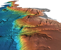
Originally designed for military use, the multibeam echosounder has proved very useful
for nautical charting, oceanographic research and modeling, habitat classification,
maritime commerce, and recreational applications. The Multibeam Bathymetry Database
at NCEI collects and archives multibeam data from the earliest commercial installations
(circa 1980) through today's modern high-resolution collections. Data are acquired
from a variety of primarily government and academic sources (see individual cruise
metadata records for source information) and consist of the raw (as collected) sonar
data files. Datasets may also include processed or edited versions of the sonar data,
ancillary data, derived products, and/or metadata for the data collection. The Multibeam
Bathymetry Database provides data that span the globe and are discoverable and accesible
via map interface or text-only search options. |