Multibeam Bathymetry Database (MBBDB)
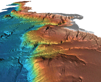 1996: Dr. Lincoln Pratson, INSTAAR/NGDC offshore California gridded multibeam data
Originally designed for military use, the multibeam echosounder has proved very useful
for nautical charting, oceanographic research and modeling, habitat classification,
maritime commerce, and recreational applications. The Multibeam Bathymetry Database
at NCEI collects and archives multibeam data from the earliest commercial installations
(circa 1980) through today's modern high-resolution collections. Data are acquired
from a variety of primarily government and academic sources (see individual cruise
metadata records for source information) and consist of the raw (as collected) sonar
data files. Datasets may also include processed or edited versions of the sonar data,
ancillary data, derived products, and/or metadata for the data collection. The Multibeam
Bathymetry Database provides data that span the globe and are discoverable and accesible
via map interface or text-only search options.
- Cite as: NOAA National Centers for Environmental Information. 2004: Multibeam Bathymetry Database (MBBDB). [cruise]. NOAA National Centers for Environmental Information. https://doi.org/doi:10.7289/V56T0JNC. Accessed [date].
- doi:10.7289/V56T0JNC
- NCEI Metadata ID: gov.noaa.ngdc:G01034
gov.noaa.ngdc:G01034
| Search Data |
|
| Distribution Formats |
|
| Ordering Instructions | Contact NCEI for other distribution options and instructions. |
| Distributor | NOAA National Centers for Environmental Information ncei.info@noaa.gov |
| Dataset Point of Contact | NOAA National Centers for Environmental Information ncei.info@noaa.gov |
| Dataset Point of Contact | Multibeam Data Manager NOAA National Centers for Environmental Information (303) 497-4613 mb.info@noaa.gov |
| Time Period | 1980-01-01 to Present |
| Spatial Reference System | Through the collection reference systems have vaired with time and location. Please see survey level metadata for detailed information. |
| Spatial Bounding Box Coordinates |
West:-180
East:180
South:-90
North:90
|
| Spatial Coverage Map | |
| General Documentation |
|
| Associated Resources |
|
| Publication Dates |
|
| Dataset Progress Status | inProgress Historical archive - data has been stored in an offline storage facility |
| Data Update Frequency | As needed - Updated as needed |
| Purpose | NGDC (now NCEI) established the Multibeam Bathymetry Database to provide a comprehensive database of multibeam bathymetric data on a global scale. The intent of the dataset is to make high-resolution bathymetry available to the public for a wide variety of uses, such as research and earth science analysis. These data are NOT to be used for navigation. |
| Dataset Citation |
|
| Cited Authors |
|
| Publishers |
|
| Theme keywords | NGDA Portfolio Themes
|
| Data Center keywords | Global Change Master Directory (GCMD) Data Center Keywords
|
| Place keywords | Global Change Master Directory (GCMD) Location Keywords
|
| Project keywords | Global Change Master Directory (GCMD) Project Keywords
|
| Use Constraints |
|
| Access Constraints |
|
| Fees |
|
| Processing Steps |
|
| Instrument |
|
Last Modified: 2023-09-15
For questions about the information on this page, please email:ncei.info@noaa.gov