| Bathymetric ArcRaster Grid of Apalachicola Bay and St. George Sound, Florida (25m) | spatialRepresentationInfo|
|---|---|
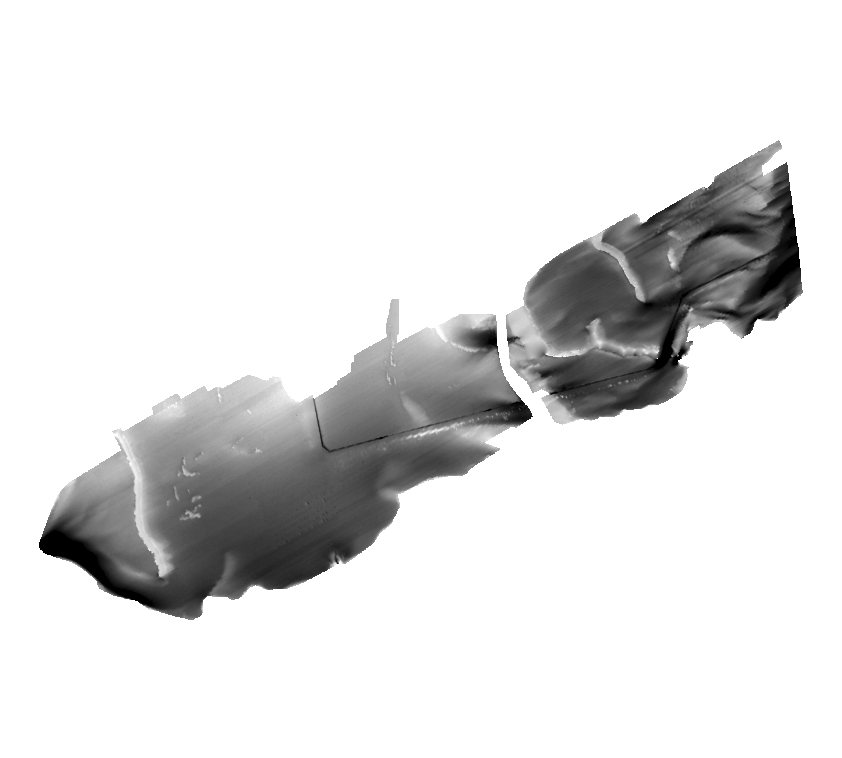
| а(MI_Metadata) ааааfileIdentifier: аgov.noaa.nmfs.inport:47876 ааааlanguage: ааааааLanguageCode: аeng ааааcharacterSet: а(MD_CharacterSetCode)аUTF8 ааааhierarchyLevel: а(MD_ScopeCode)аdataset ааааcontact: а(CI_ResponsibleParty) ааааааааorganisationName: аOffice for Coastal Management ааааааааcontactInfo: а(CI_Contact) ааааааааааааphone: а(CI_Telephone) ааааааааааааааааvoice: (missing) ааааааааааааaddress: а(CI_Address) ааааааааrole: а(CI_RoleCode)аresourceProvider ааааcontact: а(CI_ResponsibleParty) ааааааааorganisationName: аNOAA Office for Coastal Management ааааааааcontactInfo: а(CI_Contact) ааааааааааааphone: а(CI_Telephone) ааааааааааааааааvoice: а(843) 740-1202 ааааааааааааaddress: а(CI_Address) ааааааааааааааааdeliveryPoint: а2234 South Hobson Ave ааааааааааааааааcity: аCharleston ааааааааааааааааadministrativeArea: аSC ааааааааааааааааpostalCode: а29405-2413 ааааааааааааааааcountry: (missing) ааааааааааааааааelectronicMailAddress: аcoastal.info@noaa.gov ааааааааааааonlineResource: а(CI_OnlineResource) ааааааааааааааааlinkage: https://coast.noaa.gov ааааааааааааааааprotocol: аWWW:LINK-1.0-http--link ааааааааааааааааname: аNOAA Office for Coastal Management Website ааааааааааааааааdescription: аNOAA Office for Coastal Management Home Page ааааааааааааааааfunction: а(CI_OnLineFunctionCode)аinformation ааааааааrole: а(CI_RoleCode)аpointOfContact ааааdateStamp: ааааааDateTime: а2025-04-30T22:32:22 ааааmetadataStandardName: аISO 19115-2 Geographic Information - Metadata Part 2 Extensions for imagery and gridded data ааааmetadataStandardVersion: аISO 19115-2:2009(E) return to top ааааspatialRepresentationInfo: а(MD_GridSpatialRepresentation) ааааааааnumberOfDimensions: а3 ааааааааaxisDimensionProperties: а(MD_Dimension) ааааааааааааdimensionName: а(MD_DimensionNameTypeCode)аrow ааааааааааааdimensionSize: а828 ааааааааaxisDimensionProperties: а(MD_Dimension) ааааааааааааdimensionName: а(MD_DimensionNameTypeCode)аcolumn ааааааааааааdimensionSize: а1315 ааааааааaxisDimensionProperties: а(MD_Dimension) ааааааааааааdimensionName: а(MD_DimensionNameTypeCode)аvertical ааааааааааааdimensionSize: а1 ааааааааcellGeometry: а(MD_CellGeometryCode)аarea ааааааааtransformationParameterAvailability: а0 return to top ааааidentificationInfo: а(MD_DataIdentification) ааааааааcitation: а(CI_Citation) ааааааааааааtitle: аBathymetric ArcRaster Grid of Apalachicola Bay and St. George Sound, Florida (25m) ааааааааааааalternateTitle: аfl_ab06_bath-meta ааааааааааааdate: а(CI_Date) ааааааааааааааааdate: а2007 ааааааааааааааааdateType: а(CI_DateTypeCode)аpublication ааааааааааааidentifier: а(MD_Identifier) ааааааааааааааааauthority: а(CI_Citation) ааааааааааааааааааааtitle: аNOAA/NMFS/EDM ааааааааааааааааааааdate: (inapplicable) ааааааааааааааааcode: ааааааааааааааааааAnchor: аInPort Catalog IDа47876 ааааааааааааcitedResponsibleParty: а(CI_ResponsibleParty) ааааааааааааааааorganisationName: (inapplicable) ааааааааааааааааcontactInfo: а(CI_Contact) ааааааааааааааааааааonlineResource: а(CI_OnlineResource) ааааааааааааааааааааааааlinkage: https://www.fisheries.noaa.gov/inport/item/47876 ааааааааааааааааааааааааprotocol: аWWW:LINK-1.0-http--link ааааааааааааааааааааааааname: аFull Metadata Record ааааааааааааааааааааааааdescription: аView the complete metadata record on InPort for more information about this dataset. ааааааааааааааааааааааааfunction: а(CI_OnLineFunctionCode)аinformation ааааааааааааааааrole: (inapplicable) ааааааааааааcitedResponsibleParty: а(CI_ResponsibleParty) ааааааааааааааааorganisationName: (inapplicable) ааааааааааааааааcontactInfo: а(CI_Contact) ааааааааааааааааааааonlineResource: а(CI_OnlineResource) ааааааааааааааааааааааааlinkage: https://coast.noaa.gov/ ааааааааааааааааааааааааprotocol: аWWW:LINK-1.0-http--link ааааааааааааааааааааааааname: аNOAA's Office for Coastal Management (OCM) website ааааааааааааааааааааааааdescription: аInformation on the NOAA Office for Coastal Management (OCM) ааааааааааааааааааааааааfunction: а(CI_OnLineFunctionCode)аdownload ааааааааааааааааrole: (inapplicable) ааааааааааааcitedResponsibleParty: а(CI_ResponsibleParty) ааааааааааааааааorganisationName: (inapplicable) ааааааааааааааааcontactInfo: а(CI_Contact) ааааааааааааааааааааonlineResource: а(CI_OnlineResource) ааааааааааааааааааааааааlinkage: http://pubs.usgs.gov/of/2006/1381/ ааааааааааааааааааааааааprotocol: аWWW:LINK-1.0-http--link ааааааааааааааааааааааааname: аCitation URL ааааааааааааааааааааааааdescription: аOnline Resource ааааааааааааааааааааааааfunction: а(CI_OnLineFunctionCode)аdownload ааааааааааааааааrole: (inapplicable) ааааааааааааpresentationForm: а(CI_PresentationFormCode)аmapDigital ааааааааabstract: аThese data were collected under a cooperative mapping program between the U.S. Geological Survey (USGS), the National Oceanic and Atmospheric Administration Office for Coastal Management (NOAA\OCM), and the Apalachicola National Estuarine Research Reserve (NERR). The primary objectives of this program were to collect marine geophysical data to develop a suite of seafloor maps to better define the extent of oyster habitats, the overall seafloor geology of the bay and provide updated information for management of this resource. In addition to their value for management of the bay's oyster resources, the maps also provide a geologic framework for scientific research and the public. High-resolution bathymetry, backscatter intensity, and seismic profile data were collected over 230 square kilometers of the floor of the bay. The study focused on Apalachicola Bay and Western St. George Sound portions of the estuary mostly in depths > 2.0 meters. Original contact information: Contact Name: Brian Andrews Contact Org: U.S. Geological Survey Title: Geographer Phone: 508-548-8700 x2348 Email: bandrews@usgs.gov ааааааааpurpose: аThe purpose of this dataset is to produce a bathymetric grid of the area within the survey boundary in St. George Sound and Apalachicola Bay. The purpose of these data is to represent the swath bathymetry in a courser grid cell resolution but cover the gaps between survey lines. In shallow areas less than 2m deep the digitized seafloor from the ASV seismic data was used to provide single beam bathymetry. ааааааааstatus: а(MD_ProgressCode)аcompleted ааааааааpointOfContact: а(CI_ResponsibleParty) ааааааааааааorganisationName: аNOAA Office for Coastal Management ааааааааааааcontactInfo: а(CI_Contact) ааааааааааааааааphone: а(CI_Telephone) ааааааааааааааааааааvoice: а(843) 740-1202 ааааааааааааааааaddress: а(CI_Address) ааааааааааааааааааааdeliveryPoint: а2234 South Hobson Ave ааааааааааааааааааааcity: аCharleston ааааааааааааааааааааadministrativeArea: аSC ааааааааааааааааааааpostalCode: а29405-2413 ааааааааааааааааааааcountry: (missing) ааааааааааааааааааааelectronicMailAddress: аcoastal.info@noaa.gov ааааааааааааааааonlineResource: а(CI_OnlineResource) ааааааааааааааааааааlinkage: https://coast.noaa.gov ааааааааааааааааааааprotocol: аWWW:LINK-1.0-http--link ааааааааааааааааааааname: аNOAA Office for Coastal Management Website ааааааааааааааааааааdescription: аNOAA Office for Coastal Management Home Page ааааааааааааааааааааfunction: а(CI_OnLineFunctionCode)аinformation ааааааааааааrole: а(CI_RoleCode)аpointOfContact ааааааааpointOfContact: а(CI_ResponsibleParty) ааааааааааааorganisationName: аNOAA Office for Coastal Management ааааааааааааcontactInfo: а(CI_Contact) ааааааааааааааааphone: а(CI_Telephone) ааааааааааааааааааааvoice: а(843) 740-1202 ааааааааааааааааaddress: а(CI_Address) ааааааааааааааааааааdeliveryPoint: а2234 South Hobson Ave ааааааааааааааааааааcity: аCharleston ааааааааааааааааааааadministrativeArea: аSC ааааааааааааааааааааpostalCode: а29405-2413 ааааааааааааааааааааcountry: (missing) ааааааааааааааааааааelectronicMailAddress: аcoastal.info@noaa.gov ааааааааааааааааonlineResource: а(CI_OnlineResource) ааааааааааааааааааааlinkage: https://coast.noaa.gov ааааааааааааааааааааprotocol: аWWW:LINK-1.0-http--link ааааааааааааааааааааname: аNOAA Office for Coastal Management Website ааааааааааааааааааааdescription: аNOAA Office for Coastal Management Home Page ааааааааааааааааааааfunction: а(CI_OnLineFunctionCode)аinformation ааааааааааааrole: а(CI_RoleCode)аcustodian ааааааааresourceMaintenance: а(MD_MaintenanceInformation) ааааааааааааmaintenanceAndUpdateFrequency: а(MD_MaintenanceFrequencyCode)аnotPlanned ааааааааgraphicOverview: а(MD_BrowseGraphic) ааааааааааааfileName: http://pubs.usgs.gov/of/2006/1381/GIS/thumbnails/apbaybath25m.jpg ааааааааааааfileDescription: аcolor coded image ааааааааааааfileType: аJPEG ааааааааdescriptiveKeywords: а(MD_Keywords) ааааааааааааkeyword: аEARTH SCIENCE > BIOSPHERE > ECOSYSTEMS > MARINE ECOSYSTEMS > BENTHIC ааааааааааааkeyword: аEARTH SCIENCE > BIOSPHERE > ECOSYSTEMS > MARINE ECOSYSTEMS > COASTAL ааааааааааааkeyword: аEARTH SCIENCE > BIOSPHERE > ECOSYSTEMS > MARINE ECOSYSTEMS > ESTUARY ааааааааааааtype: а(MD_KeywordTypeCode)аtheme ааааааааааааthesaurusName: а(CI_Citation) ааааааааааааааааtitle: аGlobal Change Master Directory (GCMD) Science Keywords ааааааааааааааааdate: (missing) ааааааааааааааааedition: а17.0 ааааааааdescriptiveKeywords: а(MD_Keywords) ааааааааааааkeyword: аCONTINENT > NORTH AMERICA > UNITED STATES OF AMERICA > FLORIDA ааааааааааааkeyword: аOCEAN > ATLANTIC OCEAN > NORTH ATLANTIC OCEAN > GULF OF AMERICA ааааааааааааtype: а(MD_KeywordTypeCode)аplace ааааааааааааthesaurusName: а(CI_Citation) ааааааааааааааааtitle: аGlobal Change Master Directory (GCMD) Location Keywords ааааааааааааааааdate: (missing) ааааааааааааааааedition: а20.8 ааааааааdescriptiveKeywords: а(MD_Keywords) ааааааааааааkeyword: аArcGIS Raster ааааааааааааkeyword: аCMGP ааааааааааааkeyword: аCoastal and Marine Geology Program ааааааааааааkeyword: аInterferometric Sonar ааааааааааааkeyword: аMarine Geology ааааааааааааkeyword: аSeafloor ааааааааааааkeyword: аSwath Bathymetry ааааааааааааkeyword: аU.S. Geological Survey ааааааааааааkeyword: аUSGS ааааааааааааkeyword: аWHSC ааааааааааааkeyword: аWoods Hole Science Center ааааааааааааkeyword: аfield activity serial number 05001 ааааааааааааkeyword: аfield activity serial number 06001 ааааааааааааkeyword: аseafloor mapping ааааааааааааkeyword: а2005 ааааааааааааkeyword: а2006 ааааааааааааkeyword: аApalachicola Bay ааааааааааааkeyword: аApalachicola National Estuarine Research Reserve ааааааааааааkeyword: аFlorida ааааааааааааkeyword: аGulf of Mexico ааааааааааааkeyword: аSt. George Sound ааааааааааааkeyword: аUnited States ааааааааааааtype: а(MD_KeywordTypeCode)аtheme ааааааааааааthesaurusName: а(CI_Citation) ааааааааааааааааtitle: аGeneral ааааааааааааааааdate: (missing) ааааааааdescriptiveKeywords: а(MD_Keywords) ааааааааааааkeyword: аDOC/NOAA/NOS/OCM > Office of Coastal Management, National Ocean Service, NOAA, U.S. Department of Commerce ааааааааааааtype: а(MD_KeywordTypeCode)аdataCentre ааааааааааааthesaurusName: а(CI_Citation) ааааааааааааааааtitle: аGlobal Change Master Directory (GCMD) Data Center Keywords ааааааааааааааааdate: а(CI_Date) ааааааааааааааааааааdate: а2017-04-24 ааааааааааааааааааааdateType: а(CI_DateTypeCode)аpublication ааааааааааааааааedition: а8.5 ааааааааааааааааcitedResponsibleParty: а(CI_ResponsibleParty) ааааааааааааааааааааorganisationName: аEarth Science Data and Information System, Earth Science Projects Division, Goddard Space Flight Center (GSFC), National Aeronautics and Space Administration (NASA) ааааааааааааааааааааcontactInfo: а(CI_Contact) ааааааааааааааааааааааааonlineResource: а(CI_OnlineResource) ааааааааааааааааааааааааааааlinkage: https://forum.earthdata.nasa.gov/app.php/tag/GCMD%2BKeywords ааааааааааааааааааааааааааааname: аGCMD Keyword Forum Page ааааааааааааааааааааааааааааdescription: аGlobal Change Master Directory (GCMD). 2024. GCMD Keywords, Version 19. Greenbelt, MD: Earth Science Data and Information System, Earth Science Projects Division, Goddard Space Flight Center (GSFC), National Aeronautics and Space Administration (NASA). URL (GCMD Keyword Forum Page): https://forum.earthdata.nasa.gov/app.php/tag/GCMD+Keywords ааааааааааааааааааааааааааааfunction: а(CI_OnLineFunctionCode)аinformation ааааааааааааааааааааrole: а(CI_RoleCode)аcustodian ааааааааdescriptiveKeywords: а(MD_Keywords) ааааааааааааkeyword: аBenthic ааааааааааааtype: а(MD_KeywordTypeCode)аproject ааааааааааааthesaurusName: а(CI_Citation) ааааааааааааааааtitle: аInPort ааааааааааааааааdate: (inapplicable) ааааааааresourceConstraints: а(MD_LegalConstraints) ааааааааааааuseConstraints: а(MD_RestrictionCode)аotherRestrictions ааааааааааааotherConstraints: аCite As: Office for Coastal Management, [Date of Access]: Bathymetric ArcRaster Grid of Apalachicola Bay and St. George Sound, Florida (25m) [Data Date Range], https://www.fisheries.noaa.gov/inport/item/47876. ааааааааresourceConstraints: а(MD_Constraints) ааааааааааааuseLimitation: аNOAA provides no warranty, nor accepts any liability occurring from any incomplete, incorrect, or misleading data, or from any incorrect, incomplete, or misleading use of the data. It is the responsibility of the user to determine whether or not the data is suitable for the intended purpose. ааааааааresourceConstraints: а(MD_LegalConstraints) ааааааааааааaccessConstraints: а(MD_RestrictionCode)аotherRestrictions ааааааааааааotherConstraints: аAccess Constraints: None ааааааааresourceConstraints: а(MD_LegalConstraints) ааааааааааааuseConstraints: а(MD_RestrictionCode)аotherRestrictions ааааааааааааotherConstraints: аUse Constraints: Data are not intended for navigational use. These data should not be used at resolutions for which it is not intended. Public domain data from the U.S. Government are freely redistributable with proper metadata and source attribution. Please recognize the U.S. Geological Survey (USGS) as the source of this information. ааааааааresourceConstraints: а(MD_LegalConstraints) ааааааааааааuseLimitation: а(MD_RestrictionCode)аotherRestrictions ааааааааааааotherConstraints: аDistribution Liability: NOAA manages much of the data to users of digital geographic data. NOAA is in no way condoning or endorsing the application of this data for any given purpose.It is the sole responsibility of the user to determine whether or not the data is suitable for the intended purpose. It is also the obligation of the user to apply the data in an appropriate and conscientious manner.NOAA provides no warranty,nor accepts any liability occurring from any incomplete,incorrect, or misleading data, or from any incorrect,incomplete, or misleading use of the data. Much of the data is based on and maintained with ARC/GIS software developed by the Environmental Systems Research Institute (ESRI).In addition, much of the information presented uses conventions and terms popularized by ARC/GIS and its user community. NOAA in no way represents the interests of ESRI,nor acts as agents for them. Any use of trade, product, or firm names is for descriptive purposes only and does not imply endorsement by the U.S. Government. ааааааааresourceConstraints: а(MD_SecurityConstraints) ааааааааааааclassification: а(MD_ClassificationCode)аunclassified ааааааааааааclassificationSystem: (missing) ааааааааааааhandlingDescription: (missing) ааааааааaggregationInfo: а(MD_AggregateInformation) ааааааааааааaggregateDataSetName: а(CI_Citation) ааааааааааааааааtitle: аNOAA Data Management Plan (DMP) ааааааааааааааааdate: (unknown) ааааааааааааааааidentifier: а(MD_Identifier) ааааааааааааааааааааauthority: а(CI_Citation) ааааааааааааааааааааааааtitle: аNOAA/NMFS/EDM ааааааааааааааааааааааааdate: (inapplicable) ааааааааааааааааааааcode: а47876 ааааааааааааааааcitedResponsibleParty: а(CI_ResponsibleParty) ааааааааааааааааааааorganisationName: (inapplicable) ааааааааааааааааааааcontactInfo: а(CI_Contact) ааааааааааааааааааааааааonlineResource: а(CI_OnlineResource) ааааааааааааааааааааааааааааlinkage: https://www.fisheries.noaa.gov/inportserve/waf/noaa/nos/ocm/dmp/pdf/47876.pdf ааааааааааааааааааааааааааааprotocol: аWWW:LINK-1.0-http--link ааааааааааааааааааааааааааааname: аNOAA Data Management Plan (DMP) ааааааааааааааааааааааааааааdescription: аNOAA Data Management Plan for this record on InPort. ааааааааааааааааааааааааааааfunction: а(CI_OnLineFunctionCode)аinformation ааааааааааааааааааааrole: (inapplicable) ааааааааааааassociationType: а(DS_AssociationTypeCode)аcrossReference ааааааааspatialRepresentationType: а(MD_SpatialRepresentationTypeCode)аgrid ааааааааlanguage: аeng; US ааааааааtopicCategory: а(MD_TopicCategoryCode)аelevation ааааааааtopicCategory: а(MD_TopicCategoryCode)аoceans ааааааааenvironmentDescription: аMicrosoft Windows XP Version 5.1 (Build 2600) Service Pack 2; ESRI ArcCatalog 9.2.2.1350 ааааааааextent: а(EX_Extent) ааааааааааааgeographicElement: а(EX_GeographicBoundingBox) ааааааааааааааааwestBoundLongitude: а-85.096558 ааааааааааааааааeastBoundLongitude: а-84.753126 ааааааааааааааааsouthBoundLatitude: а29.597035 ааааааааааааааааnorthBoundLatitude: а29.789051 ааааааааааааtemporalElement: а(EX_TemporalExtent) ааааааааааааааааextent: ааааааааааааааааааTimeInstant: ааааааааааааааааааааdescription: а| Currentness: Ground Condition ааааааааааааааааааааtimePosition: а2005-03-14 ааааааааааааtemporalElement: а(EX_TemporalExtent) ааааааааааааааааextent: ааааааааааааааааааTimeInstant: ааааааааааааааааааааdescription: а| Currentness: Ground Condition ааааааааааааааааааааtimePosition: а2006-05-29 ааааааааааааtemporalElement: а(EX_TemporalExtent) ааааааааааааааааextent: ааааааааааааааааааTimeInstant: ааааааааааааааааааааdescription: а| Currentness: Ground Condition ааааааааааааааааааааtimePosition: а2005-04-13 ааааааааааааtemporalElement: а(EX_TemporalExtent) ааааааааааааааааextent: ааааааааааааааааааTimeInstant: ааааааааааааааааааааdescription: а| Currentness: Ground Condition ааааааааааааааааааааtimePosition: а2006-06-27 ааааааааsupplementalInformation: аThese data are a bathymetric grid of Apalachicola Bay and St. George Sound generated from swath sounding gridded at 5m. Refer to processing steps under data quality section for detailed methods. return to top ааааcontentInfo: а(MD_FeatureCatalogueDescription) ааааааааcomplianceCode: аfalse ааааааааlanguage: ааааааааааLanguageCode: аeng ааааааааincludedWithDataset: аfalse ааааааааfeatureCatalogueCitation: аhttps://www.fisheries.noaa.gov/inport/item/49278а(CI_Citation) ааааааааааааtitle: аfl_ab06_bath ааааааааааааdate: а(CI_Date) ааааааааааааааааdate: а2017-11-16 ааааааааааааааааdateType: а(CI_DateTypeCode)аpublication return to top ааааdistributionInfo: а(MD_Distribution) ааааааааdistributor: а(MD_Distributor) ааааааааааааdistributorContact: а(CI_ResponsibleParty) ааааааааааааааааorganisationName: аNOAA Office for Coastal Management ааааааааааааааааcontactInfo: а(CI_Contact) ааааааааааааааааааааphone: а(CI_Telephone) ааааааааааааааааааааааааvoice: а(843) 740-1202 ааааааааааааааааааааaddress: а(CI_Address) ааааааааааааааааааааааааdeliveryPoint: а2234 South Hobson Ave ааааааааааааааааааааааааcity: аCharleston ааааааааааааааааааааааааadministrativeArea: аSC ааааааааааааааааааааааааpostalCode: а29405-2413 ааааааааааааааааааааааааcountry: (missing) ааааааааааааааааааааааааelectronicMailAddress: аcoastal.info@noaa.gov ааааааааааааааааааааonlineResource: а(CI_OnlineResource) ааааааааааааааааааааааааlinkage: https://coast.noaa.gov ааааааааааааааааааааааааprotocol: аWWW:LINK-1.0-http--link ааааааааааааааааааааааааname: аNOAA Office for Coastal Management Website ааааааааааааааааааааааааdescription: аNOAA Office for Coastal Management Home Page ааааааааааааааааааааааааfunction: а(CI_OnLineFunctionCode)аinformation ааааааааааааааааrole: а(CI_RoleCode)аdistributor ааааааааtransferOptions: а(MD_DigitalTransferOptions) ааааааааааааonLine: а(CI_OnlineResource) ааааааааааааааааlinkage: ftp://ftp.coast.noaa.gov/pub/benthic/Shallow_Water_Bathymetry/FL_ApalachicolaBay_bath.zip ааааааааааааааааprotocol: аWWW:LINK-1.0-http--link ааааааааааааааааname: аBulk Download ааааааааааааааааdescription: аFTP download of data files. ааааааааааааааааfunction: а(CI_OnLineFunctionCode)аdownload ааааааааtransferOptions: а(MD_DigitalTransferOptions) ааааааааааааonLine: а(CI_OnlineResource) ааааааааааааааааlinkage: http://pubs.usgs.gov/of/2006/1381/GIS/raster/bath/apbaybath25m.zip ааааааааааааааааprotocol: аWWW:LINK-1.0-http--link ааааааааааааааааname: http://pubs.usgs.gov/of/2006/1381/GIS/raster/bath/apbaybath25m.zip ааааааааааааааааdescription: аDownloadable Data ааааааааааааааааfunction: а(CI_OnLineFunctionCode)аdownload return to top ааааdataQualityInfo: а(DQ_DataQuality) ааааааааscope: а(DQ_Scope) ааааааааааааlevel: а(MD_ScopeCode)аdataset ааааааааreport: а(DQ_AbsoluteExternalPositionalAccuracy) ааааааааааааnameOfMeasure: аHorizontal Positional Accuracy ааааааааааааevaluationMethodDescription: аDGPS is assumed to be accurate within 1-2 meters. Standard GPS is assumed accurate within 5-10 meters. 99% of the positional data is DGPS. Unless noted, all GPS/DGPS data is referenced to WGS84 (NAD83). The configuration of the fathometer is as follows: the transducer on the RAFAEL was mounted on a pole at the vessel's bow. Offset between the bow mount and GPS antenna is measured. On ASV IRIS, the subbottom profiler used to measure water depth was mounted directly below the GPS antenna. No measurements were taken of ship's pitch, yaw, heave, or change in draft due to water and fuel usage. Motion of the fathometer is not measured. Horizontal accuracy of the fathometer is assumed to be within +/- 3 meters. ааааааааааааresult: (missing) ааааааааreport: а(DQ_AbsoluteExternalPositionalAccuracy) ааааааааааааnameOfMeasure: аVertical Positional Accuracy ааааааааааааevaluationMethodDescription: аShip motion was recorded with a TSS DMS 2-05 Attitude Sensor, mounted on a head above the interferometric Submetrix 2000 Series transducers. Navigation was recorded using Real Time Kinematic Differential Global Positioning System (RTK-DGPS). The interferometric sonar is an angle-measuring system; depth accuracy decreases with increasing horizontal range. The combined angular accuracy of the Submetrix 2000 Series and the TSS DMS 2-05 attitude sensor is documented as 0.1 degrees. Assuming a constant angular accuracy, and using the International Hydrographic Standard (IHO) of a required 0.3 meter accuracy in < 30 meter water depth, all data collected within the survey fall within the IHO accuracy standards. However, vertical accuracy is also directly affected by the accuracy of both the navigation system and tidal measurements. RTK DGPS vertical accuracy is assumed to be 0.2 meters. Tidal elevations were derived from RTK -DGPS heights sent from a survey-specific base station located on St. George Island. The base station occupied a temporary monument. The x & y positions were calculated for that location using a 3 day average of 12 hour data sets using the Online Positioning User Service (OPUS, National Geodetic Survey) solution. Tidal elevations were calculated from NOAA Tidal Station #8728690 using the same OPUS solution and then applied to the corrected elevations for the base station at St. George Island. Antenna heights were referenced to Mean Lower Low Water (MLLW) for easier comparison of NOAA nautical charts. ааааааааааааresult: (missing) ааааааааreport: а(DQ_CompletenessCommission) ааааааааааааnameOfMeasure: аCompleteness Report ааааааааааааevaluationMethodDescription: аSoundings were gridded in OMG SwathEd software using the entire swath width across track to achieve maximum coverage at the scale of the entire Apalachicola Bay/St. George Sound survey area. Although the soundings were manually edited, small data spikes may exist at outer edges of some swaths. Pockmark features that appear in the dredge channel of the intracoastal waterway fairways are artifacts of the processing methods used to generate a continuous surface from swath bathymetry collected on lines spaced 100m apart. ааааааааааааresult: (missing) ааааааааreport: а(DQ_ConceptualConsistency) ааааааааааааnameOfMeasure: аConceptual Consistency ааааааааааааevaluationMethodDescription: аThese data have not been quantitatively compared to previous hydrographic data, although they generally agree with qualitative comparison of published NOAA charts. ааааааааааааresult: (missing) ааааааааlineage: а(LI_Lineage) ааааааааааааstatement: (missing) ааааааааааааprocessStep: а(LI_ProcessStep) ааааааааааааааааdescription: аBathymetric data were corrected for variations in the speed of sound throughout the water column; sound velocity profiles were acquired throughout the survey area using an Applied MicroSystems SVPlus Sound Velocimeter. These data were downloaded and reformatted to the required format needed for use within University of New Brunswick's Ocean Mapping Group (OMG) SwathEd multibeam processing software. The raw Submetrix 2000 Series data were "unraveled" and reformatted into the OMG format. This process creates several files on disk: 1) bathymetric soundings 2) raw sidescan backscatter 3) navigation 4) parameter files describing the configuration of the system (i.e. offsets between motion reference unit and GPS antenna, etc). This process also incorporates the sound velocity profiles in order to properly trace the rays given the structure of the water column. ааааааааааааааааdateTime: ааааааааааааааааааDateTime: а2006-10-01T00:00:00 ааааааааааааprocessStep: а(LI_ProcessStep) ааааааааааааааааdescription: аThe OMG formatted bathymetric data were then graphically edited using the SwathEd multibeam processing software. This step enabled editing on a "ping-by-ping" basis, both in the across- and along-track dimension. Spurious or erroneous data were removed. The navigation data were also graphically examined for each line of data. ааааааааааааааааdateTime: ааааааааааааааааааDateTime: а2006-10-01T00:00:00 ааааааааааааprocessStep: а(LI_ProcessStep) ааааааааааааааааdescription: аSoundings were corrected to mean lower low water (MLLW) using high-resolution Real-Time Kinematic Global Positioning System (RTKGPS) measurements. The one second RTK data were smoothed in MatLab using a 3rd order polynomial and then merged with each line file in SwathEd. ааааааааааааааааdateTime: ааааааааааааааааааDateTime: а2006-10-01T00:00:00 ааааааааааааprocessStep: а(LI_ProcessStep) ааааааааааааааааdescription: аSoundings data were gridded using the weigh_grid routines from SwathEd. Soundings were corrected to mean lower low water during the weigh_grid operation using the real time kinematic differential global positioning navigation files. The final weigh_grid parameters used were: weigh_grid -omg -coeffs -butter -lambda 5 -cutoff 20 Max_incidence angle was not used on most lines to allow usage of bathymetry data points from a broader section of the swath. Only lines from rough days, when the vessel heave was large, were gridded with a small incidence angle to maximize the good data from adjacent lanes and reduce the noisy data. ааааааааааааааааdateTime: ааааааааааааааааааDateTime: а2006-10-01T00:00:00 ааааааааааааprocessStep: а(LI_ProcessStep) ааааааааааааааааdescription: аFinal soundings were gridded to a 5m grid cell resolution using SwathEd weigh_grid command and the following gridding parameters: weigh_grid -omg -coeffs -butter -power 2 -lambda 1 -cutoff 4 -max_incidence 60 A 5m grid cell size reduced the number of points and a max_incidence of 60 degrees was used to remove the outer soundings which tended to be noisy. ааааааааааааааааdateTime: ааааааааааааааааааDateTime: а2006-10-01T00:00:00 ааааааааааааprocessStep: а(LI_ProcessStep) ааааааааааааааааdescription: аThe final grid in SwathEd OMG format was imported directly into IVS DMagic software producing a .geo, .dtm, and .shade file. The dtm file was exported to an x,y,z comma delimited file. ааааааааааааааааdateTime: ааааааааааааааааааDateTime: а2006-10-01T00:00:00 ааааааааааааprocessStep: а(LI_ProcessStep) ааааааааааааааааdescription: аThe comma-delimited x,y,z file of bathymetry was added to ArcMap as an event theme and converted to a point feature class. Two separate x,y,z files and feature classes were processed; one for Apalachicola Bay, and one for St. George Sound. ааааааааааааааааdateTime: ааааааааааааааааааDateTime: а2006-10-01T00:00:00 ааааааааааааprocessStep: а(LI_ProcessStep) ааааааааааааааааdescription: аThe remaining geoprocessing steps were completed using one model developed in ArcGIS Modelbuilder. The Model is included in the geodatabase distributed with the Open-File Report. Each of the processing steps used to Create the Model for St. George Sound are described below. The same processing steps were used to create a second Model for Apalachicola Bay using the same steps. Created empty TIN and added the x,y,z points using the geoprocessing history below: Create TIN *Date: 20061027 *Time: 113410 *Tool location: C:\Program Files\ArcGIS\ArcToolbox\Toolboxes\3D Analyst Tools.tbx\CreateTin *Command issued: CreateTin D:\GIS\FL\rafa06001\ArcGIS\Bathy\BathInterp\Tin\StGTin "PROJCS['WGS_1984_UTM_Zone_16N',GEOGCS['GCS_WGS_1984',DATUM['D_WGS_1984',SPHEROID['WGS_1984',6378137.0,298.257223563]],PRIMEM['Greenwich',0.0],UNIT['Degree',0.0174532925199433]],PROJECTION['Transverse_Mercator'],PARAMETER['False_Easting',500000.0],PARAMETER['False_Northing',0.0],PARAMETER['Central_Meridian',-87.0],PARAMETER['Scale_Factor',0.9996],PARAMETER['Latitude_Of_Origin',0.0],UNIT['Meter',1.0]];-10000 -10000 100000;0 100000;0 100000" ааааааааааааааааdateTime: ааааааааааааааааааDateTime: а2006-10-01T00:00:00 ааааааааааааprocessStep: а(LI_ProcessStep) ааааааааааааааааdescription: аAdded 5m xyz points to TIN See geoprocessing history below: Process: *Process name: Edit TIN *Date: 20061027 *Time: 113535 *Tool location: C:\Program Files\ArcGIS\ArcToolbox\Toolboxes\3D Analyst Tools.tbx\EditTin *Command issued: EditTin D:\GIS\FL\rafa06001\ArcGIS\Bathy\BathInterp\Tin\stgtin "StG_5mc_xyz depth masspoints false;BathClip <None> <None> hardclip false" D:\GIS\FL\rafa06001\ArcGIS\Bathy\BathInterp\Tin\stgtin ааааааааааааааааdateTime: ааааааааааааааааааDateTime: а2006-10-01T00:00:00 ааааааааааааprocessStep: а(LI_ProcessStep) ааааааааааааааааdescription: аConverted Tin to Raster using Natural Neighbors using floating point and natural neighbors options. Cells size was set at 25m. ааааааааааааааааdateTime: ааааааааааааааааааDateTime: а2007-01-01T00:00:00 ааааааааааааprocessStep: а(LI_ProcessStep) ааааааааааааааааdescription: аOutput Raster was clipped to a polygon boundary delineating the extent of bathymetric data. ааааааааааааааааdateTime: ааааааааааааааааааDateTime: а2007-01-01T00:00:00 ааааааааааааprocessStep: а(LI_ProcessStep) ааааааааааааааааdescription: аThe clipped 25m bathymetric grid was smoothed with a 3x3 low-pass filter. ааааааааааааааааdateTime: ааааааааааааааааааDateTime: а2007-01-01T00:00:00 ааааааааааааprocessStep: а(LI_ProcessStep) ааааааааааааааааdescription: аIndividual 25m smoothed grids of Apalachicola Bay and St. George Sound were merged together to make one grid for both areas. ааааааааааааааааdateTime: ааааааааааааааааааDateTime: а2007-01-01T00:00:00 | |