| AIS Ship Traffic: Hawaii: 2008-2009: Binned: 1km | spatialRepresentationInfo|
|---|---|
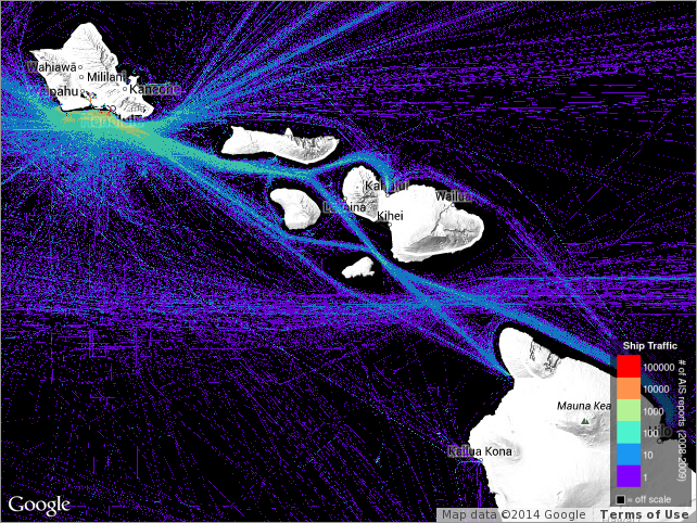
| а(MI_Metadata) ааааfileIdentifier: аais_hi_20082009_grid ааааlanguage: ааааааLanguageCode: аeng ааааcharacterSet: а(MD_CharacterSetCode)аUTF8 ааааhierarchyLevel: а(MD_ScopeCode)аdataset ааааhierarchyLevel: а(MD_ScopeCode)аservice ааааcontact: а(CI_ResponsibleParty) ааааааааindividualName: аJames T. Potemra ааааааааorganisationName: аUniversity of Hawaii at Manoa ааааааааcontactInfo: а(CI_Contact) ааааааааааааaddress: а(CI_Address) ааааааааааааааааelectronicMailAddress: аjimp@hawaii.edu ааааааааааааonlineResource: а(CI_OnlineResource) ааааааааааааааааlinkage: http://iprc.soest.hawaii.edu/people/potemra.php ааааааааааааааааprotocol: аhttp ааааааааааааааааapplicationProfile: аweb browser ааааааааааааааааname: ааааааааааааааааdescription: ааааааааааааааааfunction: а(CI_OnLineFunctionCode)аinformation ааааааааrole: а(CI_RoleCode)аpointOfContact ааааdateStamp: а2021-03-25 ааааmetadataStandardName: аISO 19115-2 Geographic Information - Metadata Part 2 Extensions for imagery and gridded data ааааmetadataStandardVersion: аISO 19115-2:2009(E) return to top ааааspatialRepresentationInfo: а(MD_GridSpatialRepresentation) ааааааааnumberOfDimensions: а2 ааааааааaxisDimensionProperties: а(MD_Dimension) ааааааааааааdimensionName: а(MD_DimensionNameTypeCode)аcolumn ааааааааааааdimensionSize: а6000 ааааааааааааresolution: ааааааааааааааMeasure: а9.999988197902775E-4 ааааааааaxisDimensionProperties: а(MD_Dimension) ааааааааааааdimensionName: а(MD_DimensionNameTypeCode)аrow ааааааааааааdimensionSize: а5000 ааааааааааааresolution: ааааааааааааааMeasure: а0.0010000001098852582 ааааааааcellGeometry: а(MD_CellGeometryCode)аarea ааааааааtransformationParameterAvailability: (unknown) return to top ааааidentificationInfo: а(MD_DataIdentification) ааааааааcitation: а(CI_Citation) ааааааааааааtitle: аAIS Ship Traffic: Hawaii: 2008-2009: Binned: 1km ааааааааааааdate: а(CI_Date) ааааааааааааааааdate: а2010-04-01 ааааааааааааааааdateType: а(CI_DateTypeCode)аcreation ааааааааааааdate: а(CI_Date) ааааааааааааааааdate: а2013-01-08 ааааааааааааааааdateType: а(CI_DateTypeCode)аissued ааааааааааааdate: а(CI_Date) ааааааааааааааааdate: а2010-04-01 ааааааааааааааааdateType: а(CI_DateTypeCode)аrevision ааааааааааааidentifier: а(MD_Identifier) ааааааааааааааааauthority: а(CI_Citation) ааааааааааааааааааааtitle: аorg.pacioos ааааааааааааааааааааdate: (inapplicable) ааааааааааааааааcode: аais_hi_20082009_grid ааааааааааааcitedResponsibleParty: а(CI_ResponsibleParty) ааааааааааааааааindividualName: аJames T. Potemra ааааааааааааааааorganisationName: аUniversity of Hawaii at Manoa ааааааааааааааааcontactInfo: а(CI_Contact) ааааааааааааааааааааaddress: а(CI_Address) ааааааааааааааааааааааааelectronicMailAddress: аjimp@hawaii.edu ааааааааааааааааааааonlineResource: а(CI_OnlineResource) ааааааааааааааааааааааааlinkage: http://iprc.soest.hawaii.edu/people/potemra.php ааааааааааааааааааааааааprotocol: аhttp ааааааааааааааааааааааааapplicationProfile: аweb browser ааааааааааааааааааааааааname: ааааааааааааааааааааааааdescription: ааааааааааааааааааааааааfunction: а(CI_OnLineFunctionCode)аinformation ааааааааааааааааrole: а(CI_RoleCode)аoriginator ааааааааааааcitedResponsibleParty: а(CI_ResponsibleParty) ааааааааааааааааorganisationName: аU.S. Coast Guard (USCG) ааааааааааааааааcontactInfo: а(CI_Contact) ааааааааааааааааааааonlineResource: а(CI_OnlineResource) ааааааааааааааааааааааааlinkage: https://www.navcen.uscg.gov ааааааааааааааааааааааааprotocol: аhttp ааааааааааааааааааааааааapplicationProfile: аweb browser ааааааааааааааааааааааааname: ааааааааааааааааааааааааdescription: ааааааааааааааааааааааааfunction: а(CI_OnLineFunctionCode)аinformation ааааааааааааааааrole: а(CI_RoleCode)аresourceProvider ааааааааааааcitedResponsibleParty: а(CI_ResponsibleParty) ааааааааааааааааorganisationName: аPacific Islands Ocean Observing System (PacIOOS) ааааааааааааааааcontactInfo: а(CI_Contact) ааааааааааааааааааааaddress: а(CI_Address) ааааааааааааааааааааааааelectronicMailAddress: аinfo@pacioos.org ааааааааааааааааааааonlineResource: а(CI_OnlineResource) ааааааааааааааааааааааааlinkage: http://pacioos.org ааааааааааааааааааааааааprotocol: аhttp ааааааааааааааааааааааааapplicationProfile: аweb browser ааааааааааааааааааааааааname: ааааааааааааааааааааааааdescription: ааааааааааааааааааааааааfunction: а(CI_OnLineFunctionCode)аinformation ааааааааааааааааrole: а(CI_RoleCode)аpublisher ааааааааabstract: аShip traffic for the State of Hawaii, identifying the number of times a vessel occupied each square kilometer during the period 2008-2009. The Automatic Identification System (AIS) is an internationally-recognized shipboard broadcast system that communicates information to shore-based stations and other AIS-equipped ships. The U.S. Coast Guard (USCG) has developed rules applicable to both U.S. and foreign vessels that require owners and operators of most commercial vessels to install and use AIS to increase security and safety of maritime transportation. PacIOOS obtained AIS data from the USCG Nationwide AIS (NAIS) project. While specific times for ship locations were redacted, the data represent a cumulation over the two-year period 2008-2009 from which ship frequency was computed at 1-km resolution. ааааааааpurpose: аPacIOOS provides timely, reliable, and accurate ocean information to support a safe, clean, productive ocean and resilient coastal zone in the U.S. Pacific Islands region. ааааааааcredit: аThe Pacific Islands Ocean Observing System (PacIOOS) is funded through the National Oceanic and Atmospheric Administration (NOAA) as a Regional Association within the U.S. Integrated Ocean Observing System (IOOS). PacIOOS is coordinated by the University of Hawaii School of Ocean and Earth Science and Technology (SOEST). ааааааааpointOfContact: а(CI_ResponsibleParty) ааааааааааааindividualName: аJames T. Potemra ааааааааааааorganisationName: аUniversity of Hawaii at Manoa ааааааааааааcontactInfo: а(CI_Contact) ааааааааааааааааaddress: а(CI_Address) ааааааааааааааааааааelectronicMailAddress: аjimp@hawaii.edu ааааааааааааааааonlineResource: а(CI_OnlineResource) ааааааааааааааааааааlinkage: http://iprc.soest.hawaii.edu/people/potemra.php ааааааааааааааааааааprotocol: аhttp ааааааааааааааааааааapplicationProfile: аweb browser ааааааааааааааааааааname: ааааааааааааааааааааdescription: ааааааааааааааааааааfunction: а(CI_OnLineFunctionCode)аinformation ааааааааааааrole: а(CI_RoleCode)аpointOfContact ааааааааgraphicOverview: а(MD_BrowseGraphic) ааааааааааааfileName: http://pacioos.org/metadata/browse/ais_hi_20082009_grid.png ааааааааааааfileDescription: аSample image. ааааааааdescriptiveKeywords: а(MD_Keywords) ааааааааааааkeyword: аEarth Science > Human Dimensions > Infrastructure > Transportation > TEST ааааааааааааtype: а(MD_KeywordTypeCode)аtheme ааааааааааааthesaurusName: а(CI_Citation) ааааааааааааааааtitle: аGCMD Science Keywords ааааааааааааааааdate: (unknown) ааааааааdescriptiveKeywords: а(MD_Keywords) ааааааааааааkeyword: аEarth Observation Satellites ааааааааааааkeyword: аNavigation Platforms ааааааааааааtype: а(MD_KeywordTypeCode)аtheme ааааааааааааthesaurusName: а(CI_Citation) ааааааааааааааааtitle: аGCMD Platform Keywords ааааааааааааааааdate: (unknown) ааааааааdescriptiveKeywords: а(MD_Keywords) ааааааааааааkeyword: аEarth Remote Sensing Instruments > Passive Remote Sensing > Positioning/Navigation ааааааааааааtype: а(MD_KeywordTypeCode)аtheme ааааааааааааthesaurusName: а(CI_Citation) ааааааааааааааааtitle: аGCMD Instrument Keywords ааааааааааааааааdate: (unknown) ааааааааdescriptiveKeywords: а(MD_Keywords) ааааааааааааkeyword: аContinent > North America > United States Of America > Hawaii ааааааааааааkeyword: аOcean > Pacific Ocean > Central Pacific Ocean > Hawaiian Islands ааааааааааааtype: а(MD_KeywordTypeCode)аplace ааааааааааааthesaurusName: а(CI_Citation) ааааааааааааааааtitle: аGCMD Location Keywords ааааааааааааааааdate: (unknown) ааааааааdescriptiveKeywords: а(MD_Keywords) ааааааааааааkeyword: аPacIOOS > Pacific Islands Ocean Observing System ааааааааааааtype: а(MD_KeywordTypeCode)аproject ааааааааааааthesaurusName: а(CI_Citation) ааааааааааааааааtitle: аGCMD Project Keywords ааааааааааааааааdate: (unknown) ааааааааdescriptiveKeywords: а(MD_Keywords) ааааааааааааkeyword: аPacIOOS > Pacific Islands Ocean Observing System ааааааааааааtype: а(MD_KeywordTypeCode)аdataCenter ааааааааааааthesaurusName: а(CI_Citation) ааааааааааааааааtitle: аGCMD Data Center Keywords ааааааааааааааааdate: (unknown) ааааааааdescriptiveKeywords: а(MD_Keywords) ааааааааааааkeyword: аlatitude ааааааааааааkeyword: аlongitude ааааааааааааtype: а(MD_KeywordTypeCode)аtheme ааааааааааааthesaurusName: а(CI_Citation) ааааааааааааааааtitle: аCF Standard Name Table v39 ааааааааааааааааdate: (unknown) ааааааааresourceConstraints: а(MD_LegalConstraints) ааааааааааааuseLimitation: аThe data may be used and redistributed for free but is not intended for legal use, since it may contain inaccuracies. Neither the data Contributor, University of Hawaii, PacIOOS, NOAA, State of Hawaii nor the United States Government, nor any of their employees or contractors, makes any warranty, express or implied, including warranties of merchantability and fitness for a particular purpose, or assumes any legal liability for the accuracy, completeness, or usefulness, of this information. ааааааааaggregationInfo: а(MD_AggregateInformation) ааааааааааааaggregateDataSetName: а(CI_Citation) ааааааааааааааааtitle: аPacific Islands Ocean Observing System (PacIOOS) ааааааааааааааааdate: (inapplicable) ааааааааааааassociationType: а(DS_AssociationTypeCode)аlargerWorkCitation ааааааааааааinitiativeType: а(DS_InitiativeTypeCode)аproject ааааааааaggregationInfo: а(MD_AggregateInformation) ааааааааааааaggregateDataSetIdentifier: а(MD_Identifier) ааааааааааааааааauthority: а(CI_Citation) ааааааааааааааааааааtitle: аUnidata Common Data Model ааааааааааааааааааааdate: (inapplicable) ааааааааааааааааcode: аGrid ааааааааааааassociationType: а(DS_AssociationTypeCode)аlargerWorkCitation ааааааааааааinitiativeType: а(DS_InitiativeTypeCode)аproject ааааааааlanguage: аeng ааааааааtopicCategory: а(MD_TopicCategoryCode)аoceans ааааааааtopicCategory: а(MD_TopicCategoryCode)аtransportation ааааааааextent: а(EX_Extent) ааааааааааааgeographicElement: а(EX_GeographicBoundingBox) ааааааааааааааааextentTypeCode: а1 ааааааааааааааааwestBoundLongitude: а200.0005 ааааааааааааааааeastBoundLongitude: а205.9995 ааааааааааааааааsouthBoundLatitude: а18.0005 ааааааааааааааааnorthBoundLatitude: а22.9995 ааааааааааааtemporalElement: а(EX_TemporalExtent) ааааааааааааааааextent: ааааааааааааааааааTimePeriod: ааааааааааааааааааааdescription: ааааааааааааааааааааbeginPosition: а2008-01-01T00:00:00Z ааааааааааааааааааааendPosition: а2010-01-01T00:00:00Z ааааааааааааverticalElement: а(EX_VerticalExtent) ааааааааааааааааminimumValue: ааааааааааааааааааReal: а0.0 ааааааааааааааааmaximumValue: ааааааааааааааааааReal: а0.0 ааааааааааааааааverticalCRS: (missing) return to top ааааidentificationInfo: а(SV_ServiceIdentification) ааааааааcitation: а(CI_Citation) ааааааааааааtitle: аAIS Ship Traffic: Hawaii: 2008-2009: Binned: 1km ааааааааааааdate: а(CI_Date) ааааааааааааааааdate: а2010-04-01 ааааааааааааааааdateType: а(CI_DateTypeCode)аcreation ааааааааааааdate: а(CI_Date) ааааааааааааааааdate: а2013-01-08 ааааааааааааааааdateType: а(CI_DateTypeCode)аissued ааааааааааааdate: а(CI_Date) ааааааааааааааааdate: а2010-04-01 ааааааааааааааааdateType: а(CI_DateTypeCode)аrevision ааааааааааааcitedResponsibleParty: а(CI_ResponsibleParty) ааааааааааааааааindividualName: аJames T. Potemra ааааааааааааааааorganisationName: аUniversity of Hawaii at Manoa ааааааааааааааааcontactInfo: а(CI_Contact) ааааааааааааааааааааaddress: а(CI_Address) ааааааааааааааааааааааааelectronicMailAddress: аjimp@hawaii.edu ааааааааааааааааааааonlineResource: а(CI_OnlineResource) ааааааааааааааааааааааааlinkage: http://iprc.soest.hawaii.edu/people/potemra.php ааааааааааааааааааааааааprotocol: аhttp ааааааааааааааааааааааааapplicationProfile: аweb browser ааааааааааааааааааааааааname: ааааааааааааааааааааааааdescription: ааааааааааааааааааааааааfunction: а(CI_OnLineFunctionCode)аinformation ааааааааааааааааrole: а(CI_RoleCode)аoriginator ааааааааааааcitedResponsibleParty: а(CI_ResponsibleParty) ааааааааааааааааindividualName: аU.S. Coast Guard (USCG) ааааааааааааааааorganisationName: (missing) ааааааааааааааааcontactInfo: (missing) ааааааааааааааааrole: а(CI_RoleCode)аresourceProvider ааааааааabstract: аShip traffic for the State of Hawaii, identifying the number of times a vessel occupied each square kilometer during the period 2008-2009. The Automatic Identification System (AIS) is an internationally-recognized shipboard broadcast system that communicates information to shore-based stations and other AIS-equipped ships. The U.S. Coast Guard (USCG) has developed rules applicable to both U.S. and foreign vessels that require owners and operators of most commercial vessels to install and use AIS to increase security and safety of maritime transportation. PacIOOS obtained AIS data from the USCG Nationwide AIS (NAIS) project. While specific times for ship locations were redacted, the data represent a cumulation over the two-year period 2008-2009 from which ship frequency was computed at 1-km resolution. ааааааааserviceType: ааааааааааLocalName: аOpen Geospatial Consortium Web Map Service (WMS) ааааааааextent: а(EX_Extent) ааааааааааааgeographicElement: а(EX_GeographicBoundingBox) ааааааааааааааааextentTypeCode: а1 ааааааааааааааааwestBoundLongitude: а200.0005 ааааааааааааааааeastBoundLongitude: а205.9995 ааааааааааааааааsouthBoundLatitude: а18.0005 ааааааааааааааааnorthBoundLatitude: а22.9995 ааааааааааааtemporalElement: а(EX_TemporalExtent) ааааааааааааааааextent: ааааааааааааааааааTimePeriod: ааааааааааааааааааааbeginPosition: а2008-01-01T00:00:00Z ааааааааааааааааааааendPosition: а2010-01-01T00:00:00Z ааааааааааааverticalElement: а(EX_VerticalExtent) ааааааааааааааааminimumValue: ааааааааааааааааааReal: а0.0 ааааааааааааааааmaximumValue: ааааааааааааааааааReal: а0.0 ааааааааааааааааverticalCRS: (missing) ааааааааcouplingType: а(SV_CouplingType)аtight ааааааааcontainsOperations: а(SV_OperationMetadata) ааааааааааааoperationName: аGetCapabilities ааааааааааааDCP: (unknown) ааааааааааааconnectPoint: а(CI_OnlineResource) ааааааааааааааааlinkage: https://pae-paha.pacioos.hawaii.edu/thredds/wms/ais_hi_20082009_grid?service=WMS&version=1.3.0&request=GetCapabilities ааааааааааааааааprotocol: аOGC:WMS ааааааааааааааааname: аOGC-WMS ааааааааааааааааdescription: аOpen Geospatial Consortium Web Map Service (WMS) ааааааааааааааааfunction: а(CI_OnLineFunctionCode)аdownload ааааааааoperatesOn: а#DataIdentification return to top ааааcontentInfo: а(MI_CoverageDescription) ааааааааattributeDescription: (unknown) ааааааааcontentType: (unknown) ааааааааdimension: а(MD_Band) ааааааааааааsequenceIdentifier: ааааааааааааааMemberName: ааааааааааааааааaName: аnais ааааааааааааааааattributeType: ааааааааааааааааааTypeName: ааааааааааааааааааааaName: аint ааааааааааааdescriptor: аship frequency ааааааааааааunits: аhttp://example.org/someUnitsDictionary.xml#1 ааааааааdimension: а(MD_Band) ааааааааааааsequenceIdentifier: ааааааааааааааMemberName: ааааааааааааааааaName: аlat ааааааааааааааааattributeType: ааааааааааааааааааTypeName: ааааааааааааааааааааaName: аfloat ааааааааааааdescriptor: аlatitude (latitude) ааааааааааааunits: аhttp://example.org/someUnitsDictionary.xml#degrees_north ааааааааdimension: а(MD_Band) ааааааааааааsequenceIdentifier: ааааааааааааааMemberName: ааааааааааааааааaName: аlon ааааааааааааааааattributeType: ааааааааааааааааааTypeName: ааааааааааааааааааааaName: аfloat ааааааааааааdescriptor: аlongitude (longitude) ааааааааааааunits: аhttp://example.org/someUnitsDictionary.xml#degrees_east return to top ааааdistributionInfo: а(MD_Distribution) ааааааааdistributor: а(MD_Distributor) ааааааааааааdistributorContact: а(CI_ResponsibleParty) ааааааааааааааааindividualName: (missing) ааааааааааааааааorganisationName: аPacific Islands Ocean Observing System (PacIOOS) ааааааааааааааааcontactInfo: а(CI_Contact) ааааааааааааааааааааaddress: а(CI_Address) ааааааааааааааааааааааааelectronicMailAddress: аinfo@pacioos.org ааааааааааааааааааааonlineResource: а(CI_OnlineResource) ааааааааааааааааааааааааlinkage: http://pacioos.org ааааааааааааааааааааааааprotocol: аhttp ааааааааааааааааааааааааapplicationProfile: аweb browser ааааааааааааааааааааааааname: ааааааааааааааааааааааааdescription: ааааааааааааааааааааааааfunction: а(CI_OnLineFunctionCode)аinformation ааааааааааааааааrole: а(CI_RoleCode)аpublisher ааааааааааааdistributorFormat: а(MD_Format) ааааааааааааааааname: аOPeNDAP ааааааааааааааааversion: аDAP/2.0 ааааааааааааdistributorTransferOptions: а(MD_DigitalTransferOptions) ааааааааааааааааonLine: а(CI_OnlineResource) ааааааааааааааааааааlinkage: https://pae-paha.pacios.hawaii.edu/thredds/ais.html?dataset=ais_hi_20082009_grid ааааааааааааааааааааprotocol: аUNIDATA:THREDDS ааааааааааааааааааааname: аTHREDDS Catalog ааааааааааааааааааааdescription: аThis URL provides a catalog page for this dataset within THREDDS Data Server (TDS). ааааааааааааааааааааfunction: а(CI_OnLineFunctionCode)аdownload ааааааааааааdistributorTransferOptions: а(MD_DigitalTransferOptions) ааааааааааааааааonLine: а(CI_OnlineResource) ааааааааааааааааааааlinkage: http://pacioos.org/voyager/index.html?b=18.211023%2C-162.144443%2C22.844475%2C-152.811557&s=1&t=m&o=traff:1::d1c52a0b6 ааааааааааааааааааааprotocol: аhttp ааааааааааааааааааааname: аPacIOOS Voyager (Google Maps API) ааааааааааааааааааааdescription: аThis URL provides a viewer and/or data access for this dataset. ааааааааааааааааааааfunction: а(CI_OnLineFunctionCode)аdownload ааааааааааааdistributorTransferOptions: а(MD_DigitalTransferOptions) ааааааааааааааааonLine: а(CI_OnlineResource) ааааааааааааааааааааlinkage: https://www.navcen.uscg.gov/?pageName=AISmain ааааааааааааааааааааprotocol: аhttp ааааааааааааааааааааname: аRelated URL ааааааааааааааааааааdescription: аThis URL provides additional information related to this dataset. ааааааааааааааааааааfunction: а(CI_OnLineFunctionCode)аinformation return to top ааааdataQualityInfo: а(DQ_DataQuality) ааааааааscope: а(DQ_Scope) ааааааааааааlevel: а(MD_ScopeCode)аdataset ааааааааlineage: а(LI_Lineage) ааааааааааааstatement: а2010-04-01T00:00:00Z Data obtained from USCG/NAIS by J. Potemra. return to top ааааmetadataMaintenance: а(MD_MaintenanceInformation) ааааааааmaintenanceAndUpdateFrequency: (unknown) ааааааааmaintenanceNote: аThis record was translated from NcML using UnidataDD2MI.xsl Version 2.3. | |