| NCEI/WDS Global Historical Tsunami Database, 2100 BC to Present | identificationInfo|
|---|---|
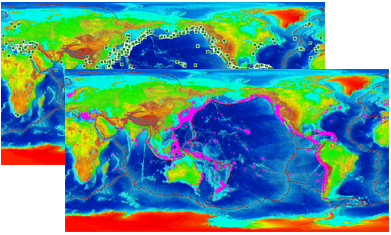
| а(MI_Metadata) ааааfileIdentifier: аgov.noaa.ngdc.mgg.hazards:G02151 ааааlanguage: аeng; USA ааааcharacterSet: а(MD_CharacterSetCode)аutf8 ааааhierarchyLevel: а(MD_ScopeCode)аdataset ааааcontact: а(CI_ResponsibleParty) ааааааааorganisationName: аNOAA National Centers for Environmental Information ааааааааpositionName: аHazards Data Manager ааааааааcontactInfo: а(CI_Contact) ааааааааааааaddress: а(CI_Address) ааааааааааааааааelectronicMailAddress: аhaz.info@noaa.gov ааааааааrole: а(CI_RoleCode)аpointOfContact ааааdateStamp: а2024-09-10 ааааmetadataStandardName: аISO 19115-2 Geographic Information - Metadata - Part 2: Extensions for Imagery and Gridded Data ааааmetadataStandardVersion: аISO 19115-2:2009(E) return to top ааааidentificationInfo: а(MD_DataIdentification) ааааааааcitation: а(CI_Citation) ааааааааааааtitle: аNCEI/WDS Global Historical Tsunami Database, 2100 BC to Present ааааааааааааdate: а(CI_Date) ааааааааааааааааdate: а1974-01-01 ааааааааааааааааdateType: а(CI_DateTypeCode)аpublication ааааааааааааidentifier: а(MD_Identifier) ааааааааааааааааcode: ааааааааааааааааааAnchor: аDOIаdoi:10.7289/V5PN93H7 ааааааааааааcitedResponsibleParty: а(CI_ResponsibleParty) ааааааааааааааааorganisationName: аNOAA National Centers for Environmental Information ааааааааааааааааrole: а(CI_RoleCode)аpublisher ааааааааааааcitedResponsibleParty: а(CI_ResponsibleParty) ааааааааааааааааorganisationName: аNational Geophysical Data Center / World Data Service (NGDC/WDS) ааааааааааааааааrole: а(CI_RoleCode)аoriginator ааааааааааааcitedResponsibleParty: а(CI_ResponsibleParty) ааааааааааааааааindividualName: аNicolas Arcos ааааааааааааааааorganisationName: аDOC/NOAA/NESDIS/NCEI > National Centers for Environmental Information, NESDIS, NOAA, U.S. Department of Commerce ааааааааааааааааcontactInfo: а(CI_Contact) ааааааааааааааааааааphone: а(CI_Telephone) ааааааааааааааааааааааааvoice: а(303) 497-3158 ааааааааааааааааааааааааfacsimile: а(303) 497-6513 ааааааааааааааааааааaddress: а(CI_Address) ааааааааааааааааааааааааdeliveryPoint: а325 Broadway, Mail Code E/NE42 ааааааааааааааааааааааааcity: аBoulder ааааааааааааааааааааааааadministrativeArea: аCO ааааааааааааааааааааааааpostalCode: а80305-3328 ааааааааааааааааааааааааcountry: аUSA ааааааааааааааааааааааааelectronicMailAddress: аhaz.info@noaa.gov ааааааааааааааааrole: а(CI_RoleCode)аpointOfContact ааааааааааааcitedResponsibleParty: а(CI_ResponsibleParty) ааааааааааааааааorganisationName: (withheld) ааааааааааааааааcontactInfo: а(CI_Contact) ааааааааааааааааааааonlineResource: а(CI_OnlineResource) ааааааааааааааааааааааааlinkage: https://www.ngdc.noaa.gov/hazard/tsu_db.shtml ааааааааааааааааааааааааprotocol: аhttp ааааааааааааааааааааааааname: аNCEI/WDS Global Historical Tsunami Database, 2100 BC to Present ааааааааааааааааааааааааdescription: аInformation on tsunami events from 2100 BC to the present in the Atlantic, Indian, and Pacific Oceans; and the Mediterranean and Caribbean Seas. ааааааааааааааааааааааааfunction: а(CI_OnLineFunctionCode)аinformation ааааааааааааааааrole: (inapplicable) ааааааааааааpresentationForm: а(CI_PresentationFormCode)аmapDigital ааааааааааааpresentationForm: а(CI_PresentationFormCode)аtableDigital ааааааааabstract: аThe Global Historical Tsunami Database provides information on over 2,400 tsunamis from 2100 BC to the present in the the Atlantic, Indian, and Pacific Oceans; and the Mediterranean and Caribbean Seas. The database includes two related files. The first file includes information on the tsunami source such as the date, time, and location of the source event; cause and validity of the source, tsunami magnitude and intensity; maximum water height; the total number of fatalities, injuries, houses destroyed, and houses damaged; and total damage estimate (in U.S. dollars). The second related file contains information on the runups (the locations where tsunami waves were observed by eyewitnesses, reconnaissance surveys, tide gauges, and deep-ocean sensors) such as name, location, arrival time, maximum water height and inundation distance, and socio-economic data (deaths, injuries, damage) for the specific runup location. ааааааааpurpose: аThese data are necessary for tsunami hazard assessments, mitigation efforts, and warning guidance. ааааааааstatus: а(MD_ProgressCode)аonGoing ааааааааpointOfContact: а(CI_ResponsibleParty) ааааааааааааindividualName: аNicolas Arcos ааааааааааааorganisationName: аDOC/NOAA/NESDIS/NCEI > National Centers for Environmental Information, NESDIS, NOAA, U.S. Department of Commerce ааааааааааааcontactInfo: а(CI_Contact) ааааааааааааааааphone: а(CI_Telephone) ааааааааааааааааааааvoice: а(303) 497-3158 ааааааааааааааааааааfacsimile: а(303) 497-6513 ааааааааааааааааaddress: а(CI_Address) ааааааааааааааааааааdeliveryPoint: а325 Broadway, Mail Code E/NE42 ааааааааааааааааааааcity: аBoulder ааааааааааааааааааааadministrativeArea: аCO ааааааааааааааааааааpostalCode: а80305-3328 ааааааааааааааааааааcountry: аUSA ааааааааааааааааааааelectronicMailAddress: аhaz.info@noaa.gov ааааааааааааrole: а(CI_RoleCode)аpointOfContact ааааааааresourceMaintenance: а(MD_MaintenanceInformation) ааааааааааааmaintenanceAndUpdateFrequency: а(MD_MaintenanceFrequencyCode)аasNeeded ааааааааgraphicOverview: а(MD_BrowseGraphic) ааааааааааааfileName: https://www.ngdc.noaa.gov/hazard/icons/tsunamis.jpg ааааааааааааfileDescription: аMaps showing tsunami events and tsunami runups and locations. ааааааааааааfileType: аjpg ааааааааdescriptiveKeywords: а(MD_Keywords) ааааааааааааkeyword: аEarth Science > Oceans > Ocean Waves > Tsunamis ааааааааааааtype: а(MD_KeywordTypeCode)аtheme ааааааааааааthesaurusName: а(CI_Citation) ааааааааааааааааtitle: аGlobal Change Master Directory (GCMD) Science Keywords ааааааааааааааааdate: а(CI_Date) ааааааааааааааааааааdate: а2024 ааааааааааааааааааааdateType: а(CI_DateTypeCode)аrevision ааааааааааааааааedition: а19 ааааааааааааааааcitedResponsibleParty: а(CI_ResponsibleParty) ааааааааааааааааааааorganisationName: аEarth Science Data and Information System, Earth Science Projects Division, Goddard Space Flight Center (GSFC), National Aeronautics and Space Administration (NASA) ааааааааааааааааааааcontactInfo: а(CI_Contact) ааааааааааааааааааааааааonlineResource: а(CI_OnlineResource) ааааааааааааааааааааааааааааlinkage: https://forum.earthdata.nasa.gov/app.php/tag/GCMD%2BKeywords ааааааааааааааааааааааааааааname: аGCMD Keyword Forum Page ааааааааааааааааааааааааааааdescription: аGlobal Change Master Directory (GCMD). 2024. GCMD Keywords, Version 19. Greenbelt, MD: Earth Science Data and Information System, Earth Science Projects Division, Goddard Space Flight Center (GSFC), National Aeronautics and Space Administration (NASA). URL (GCMD Keyword Forum Page): https://forum.earthdata.nasa.gov/app.php/tag/GCMD+Keywords ааааааааааааааааааааааааааааfunction: а(CI_OnLineFunctionCode)аinformation ааааааааааааааааааааrole: а(CI_RoleCode)аcustodian ааааааааdescriptiveKeywords: а(MD_Keywords) ааааааааааааkeyword: аDisasters > Catastrophic Phenomena > Tsunami ааааааааааааtype: а(MD_KeywordTypeCode)аtheme ааааааааааааthesaurusName: а(CI_Citation) ааааааааааааааааtitle: аINFOTERRA Keyword Thesaurus ааааааааааааааааdate: (unknown) ааааааааdescriptiveKeywords: а(MD_Keywords) ааааааааааааkeyword: аICSU-WDS > International Council for Science - World Data System ааааааааааааtype: а(MD_KeywordTypeCode)аproject ааааааааааааthesaurusName: а(CI_Citation) ааааааааааааааааtitle: аGlobal Change Master Directory (GCMD) Project Keywords ааааааааааааааааdate: а(CI_Date) ааааааааааааааааааааdate: а2020-01-09 ааааааааааааааааааааdateType: а(CI_DateTypeCode)аpublication ааааааааааааааааedition: а9.1 ааааааааааааааааcitedResponsibleParty: а(CI_ResponsibleParty) ааааааааааааааааааааorganisationName: аEarth Science Data and Information System, Earth Science Projects Division, Goddard Space Flight Center (GSFC), National Aeronautics and Space Administration (NASA) ааааааааааааааааааааcontactInfo: а(CI_Contact) ааааааааааааааааааааааааonlineResource: а(CI_OnlineResource) ааааааааааааааааааааааааааааlinkage: https://forum.earthdata.nasa.gov/app.php/tag/GCMD%2BKeywords ааааааааааааааааааааааааааааname: аGCMD Keyword Forum Page ааааааааааааааааааааааааааааdescription: аGlobal Change Master Directory (GCMD). 2024. GCMD Keywords, Version 19. Greenbelt, MD: Earth Science Data and Information System, Earth Science Projects Division, Goddard Space Flight Center (GSFC), National Aeronautics and Space Administration (NASA). URL (GCMD Keyword Forum Page): https://forum.earthdata.nasa.gov/app.php/tag/GCMD+Keywords ааааааааааааааааааааааааааааfunction: а(CI_OnLineFunctionCode)аinformation ааааааааааааааааааааrole: а(CI_RoleCode)аcustodian ааааааааdescriptiveKeywords: а(MD_Keywords) ааааааааааааkeyword: аGlobal ааааааааааааtype: а(MD_KeywordTypeCode)аplace ааааааааааааthesaurusName: а(CI_Citation) ааааааааааааааааtitle: аGlobal Change Master Directory (GCMD) Location Keywords ааааааааааааааааdate: а(CI_Date) ааааааааааааааааааааdate: а2024 ааааааааааааааааааааdateType: а(CI_DateTypeCode)аrevision ааааааааааааааааedition: а19 ааааааааааааааааcitedResponsibleParty: а(CI_ResponsibleParty) ааааааааааааааааааааorganisationName: аEarth Science Data and Information System, Earth Science Projects Division, Goddard Space Flight Center (GSFC), National Aeronautics and Space Administration (NASA) ааааааааааааааааааааcontactInfo: а(CI_Contact) ааааааааааааааааааааааааonlineResource: а(CI_OnlineResource) ааааааааааааааааааааааааааааlinkage: https://forum.earthdata.nasa.gov/app.php/tag/GCMD%2BKeywords ааааааааааааааааааааааааааааname: аGCMD Keyword Forum Page ааааааааааааааааааааааааааааdescription: аGlobal Change Master Directory (GCMD). 2024. GCMD Keywords, Version 19. Greenbelt, MD: Earth Science Data and Information System, Earth Science Projects Division, Goddard Space Flight Center (GSFC), National Aeronautics and Space Administration (NASA). URL (GCMD Keyword Forum Page): https://forum.earthdata.nasa.gov/app.php/tag/GCMD+Keywords ааааааааааааааааааааааааааааfunction: а(CI_OnLineFunctionCode)аinformation ааааааааааааааааааааrole: а(CI_RoleCode)аcustodian ааааааааdescriptiveKeywords: а(MD_Keywords) ааааааааааааkeyword: аDOC/NOAA/NESDIS/NCEI > National Centers for Environmental Information, NESDIS, NOAA, U.S. Department of Commerce ааааааааааааkeyword: аDOC/NOAA/NESDIS/NGDC > National Geophysical Data Center, NESDIS, NOAA, U.S. Department of Commerce ааааааааааааtype: а(MD_KeywordTypeCode)аdataCentre ааааааааааааthesaurusName: а(CI_Citation) ааааааааааааааааtitle: аGlobal Change Master Directory (GCMD) Data Center Keywords ааааааааааааааааdate: а(CI_Date) ааааааааааааааааааааdate: а2020-01-09 ааааааааааааааааааааdateType: а(CI_DateTypeCode)аpublication ааааааааааааааааedition: а9.1 ааааааааааааааааcitedResponsibleParty: а(CI_ResponsibleParty) ааааааааааааааааааааorganisationName: аEarth Science Data and Information System, Earth Science Projects Division, Goddard Space Flight Center (GSFC), National Aeronautics and Space Administration (NASA) ааааааааааааааааааааcontactInfo: а(CI_Contact) ааааааааааааааааааааааааonlineResource: а(CI_OnlineResource) ааааааааааааааааааааааааааааlinkage: https://forum.earthdata.nasa.gov/app.php/tag/GCMD%2BKeywords ааааааааааааааааааааааааааааname: аGCMD Keyword Forum Page ааааааааааааааааааааааааааааdescription: аGlobal Change Master Directory (GCMD). 2024. GCMD Keywords, Version 19. Greenbelt, MD: Earth Science Data and Information System, Earth Science Projects Division, Goddard Space Flight Center (GSFC), National Aeronautics and Space Administration (NASA). URL (GCMD Keyword Forum Page): https://forum.earthdata.nasa.gov/app.php/tag/GCMD+Keywords ааааааааааааааааааааааааааааfunction: а(CI_OnLineFunctionCode)аinformation ааааааааааааааааааааrole: а(CI_RoleCode)аcustodian ааааааааresourceConstraints: а(MD_LegalConstraints) ааааааааааааuseLimitation: а(MD_RestrictionCode)аotherRestrictions ааааааааааааotherConstraints: аCite as: National Geophysical Data Center / World Data Service: NCEI/WDS Global Historical Tsunami Database. NOAA National Centers for Environmental Information. doi:10.7289/V5PN93H7 [access date] ааааааааresourceConstraints: а(MD_LegalConstraints) ааааааааааааaccessConstraints: а(MD_RestrictionCode)аotherRestrictions ааааааааааааotherConstraints: аAccess to this dataset is unrestricted. ааааааааresourceConstraints: а(MD_LegalConstraints) ааааааааааааuseConstraints: а(MD_RestrictionCode)аotherRestrictions ааааааааааааotherConstraints: аWhile every effort has been made to ensure that these data are accurate and reliable within the limits of the current state of the art, NOAA cannot assume liability for any damages caused by any errors or omissions in the data, nor as a result of the failure of the data to function on a particular system. NOAA makes no warranty, expressed or implied, nor does the fact of distribution constitute such a warranty. ааааааааaggregationInfo: а(MD_AggregateInformation) ааааааааааааaggregateDataSetName: а(CI_Citation) ааааааааааааааааtitle: аNCEI/WDS Global Significant Earthquake Database, 2150 BC to Present ааааааааааааааааdate: а(CI_Date) ааааааааааааааааааааdate: а1972-01-01 ааааааааааааааааааааdateType: а(CI_DateTypeCode)аpublication ааааааааааааааааidentifier: а(MD_Identifier) ааааааааааааааааааааcode: ааааааааааааааааааааааAnchor: аDOIаdoi:10.7289/V5TD9V7K ааааааааааааassociationType: а(DS_AssociationTypeCode)аpartOfSeamlessDatabase ааааааааааааinitiativeType: а(DS_InitiativeTypeCode)аcollection ааааааааaggregationInfo: а(MD_AggregateInformation) ааааааааааааaggregateDataSetName: а(CI_Citation) ааааааааааааааааtitle: аNCEI/WDS Global Significant Volcanic Eruptions Database, 4360 BC to Present ааааааааааааааааdate: а(CI_Date) ааааааааааааааааааааdate: а2001-03-23 ааааааааааааааааааааdateType: а(CI_DateTypeCode)аpublication ааааааааааааааааidentifier: а(MD_Identifier) ааааааааааааааааааааcode: ааааааааааааааааааааааAnchor: аDOIаdoi:10.7289/V5JW8BSH ааааааааааааassociationType: а(DS_AssociationTypeCode)аpartOfSeamlessDatabase ааааааааааааinitiativeType: а(DS_InitiativeTypeCode)аcollection ааааааааaggregationInfo: а(MD_AggregateInformation) ааааааааааааaggregateDataSetName: а(CI_Citation) ааааааааааааааааtitle: аNCEI/WDS Global Tsunami Deposits Database ааааааааааааааааdate: а(CI_Date) ааааааааааааааааааааdate: а2001-03-23 ааааааааааааааааааааdateType: а(CI_DateTypeCode)аpublication ааааааааааааааааidentifier: а(MD_Identifier) ааааааааааааааааааааcode: аgov.noaa.ngdc.mgg.hazards:G10146 ааааааааааааassociationType: а(DS_AssociationTypeCode)аcrossReference ааааааааааааinitiativeType: а(DS_InitiativeTypeCode)аcollection ааааааааaggregationInfo: а(MD_AggregateInformation) ааааааааааааaggregateDataSetName: а(CI_Citation) ааааааааааааааааtitle: аSize of great earthquakes of 1837-1974 inferred from tsunami data. ааааааааааааааааdate: а(CI_Date) ааааааааааааааааааааdate: а1979-01-01 ааааааааааааааааааааdateType: а(CI_DateTypeCode)аpublication ааааааааааааааааidentifier: а(MD_Identifier) ааааааааааааааааааааcode: ааааааааааааааааааааааAnchor: аDOIаdoi:10.1029/JB084iB04p01561 ааааааааааааааааcitedResponsibleParty: а(CI_ResponsibleParty) ааааааааааааааааааааorganisationName: аAbe, Katsuyuki ааааааааааааааааааааrole: а(CI_RoleCode)аauthor ааааааааааааааааseries: а(CI_Series) ааааааааааааааааааааname: аJournal of Geophysical Research ааааааааааааааааааааissueIdentification: а84(B4) ааааааааааааааааotherCitationDetails: аpp. 1561-1568 ааааааааааааassociationType: а(DS_AssociationTypeCode)аcrossReference ааааааааааааinitiativeType: а(DS_InitiativeTypeCode)аsciencePaper ааааааааaggregationInfo: а(MD_AggregateInformation) ааааааааааааaggregateDataSetName: а(CI_Citation) ааааааааааааааааtitle: аMagnitudes of Large Shallow Earthquakes from 1904 to 1980. ааааааааааааааааdate: а(CI_Date) ааааааааааааааааааааdate: а1981-01-01 ааааааааааааааааааааdateType: а(CI_DateTypeCode)аpublication ааааааааааааааааidentifier: а(MD_Identifier) ааааааааааааааааааааcode: ааааааааааааааааааааааAnchor: аDOIаdoi:10.1016/0031-9201(81)90088-1 ааааааааааааааааcitedResponsibleParty: а(CI_ResponsibleParty) ааааааааааааааааааааorganisationName: аAbe, Katsuyuki ааааааааааааааааааааrole: а(CI_RoleCode)аauthor ааааааааааааааааseries: а(CI_Series) ааааааааааааааааааааname: аPhysics of the Earth and Planetary Interiors ааааааааааааааааааааissueIdentification: а27 ааааааааааааааааotherCitationDetails: аpp. 72-92 ааааааааааааassociationType: а(DS_AssociationTypeCode)аcrossReference ааааааааааааinitiativeType: а(DS_InitiativeTypeCode)аsciencePaper ааааааааaggregationInfo: а(MD_AggregateInformation) ааааааааааааaggregateDataSetName: а(CI_Citation) ааааааааааааааааtitle: аPreliminary Catalog of Tsunamis Occurring in the Pacific Ocean ааааааааааааааааdate: а(CI_Date) ааааааааааааааааааааdate: а1967-12-01 ааааааааааааааааааааdateType: а(CI_DateTypeCode)аpublication ааааааааааааааааcitedResponsibleParty: а(CI_ResponsibleParty) ааааааааааааааааааааorganisationName: аIida, Kumizi ааааааааааааааааааааrole: а(CI_RoleCode)аauthor ааааааааааааааааcitedResponsibleParty: а(CI_ResponsibleParty) ааааааааааааааааааааorganisationName: аCox, Doak C. ааааааааааааааааааааrole: а(CI_RoleCode)аauthor ааааааааааааааааcitedResponsibleParty: а(CI_ResponsibleParty) ааааааааааааааааааааorganisationName: аPararas-Carayannis, George ааааааааааааааааааааrole: а(CI_RoleCode)аauthor ааааааааааааааааseries: а(CI_Series) ааааааааааааааааааааname: аHawaii Institute of Geophysics Report ааааааааааааааааааааissueIdentification: аHIG-67-10 ааааааааааааааааotherCitationDetails: а275 p. ааааааааааааassociationType: а(DS_AssociationTypeCode)аcrossReference ааааааааааааinitiativeType: а(DS_InitiativeTypeCode)аsciencePaper ааааааааlanguage: аeng; USA ааааааааtopicCategory: а(MD_TopicCategoryCode)аoceans ааааааааtopicCategory: а(MD_TopicCategoryCode)аgeoscientificInformation ааааааааextent: а(EX_Extent) ааааааааааааgeographicElement: а(EX_GeographicBoundingBox) ааааааааааааааааwestBoundLongitude: а-180 ааааааааааааааааeastBoundLongitude: а180 ааааааааааааааааsouthBoundLatitude: а-63 ааааааааааааааааnorthBoundLatitude: а71 ааааааааааааtemporalElement: а(EX_TemporalExtent) ааааааааааааааааextent: ааааааааааааааааааTimePeriod: ааааааааааааааааааааbeginPosition: а-2100 ааааааааааааааааааааendPosition: return to top ааааcontentInfo: а(MI_CoverageDescription) ааааааааattributeDescription: ааааааааааRecordType: аTsunami Source Date ааааааааcontentType: а(MD_CoverageContentTypeCode)аphysicalMeasurement return to top ааааcontentInfo: а(MI_CoverageDescription) ааааааааattributeDescription: ааааааааааRecordType: аTsunami Source Location ааааааааcontentType: а(MD_CoverageContentTypeCode)аphysicalMeasurement ааааааааdimension: а(MD_Band) ааааааааааааsequenceIdentifier: ааааааааааааааMemberName: ааааааааааааааааaName: аSource Latitude ааааааааааааааааattributeType: (unknown) ааааааааааааdescriptor: аDistance measured north or south from the equator. Distance north is positive, distance south is negative. ааааааааааааmaxValue: ааааааааааааааReal: а90.00000 ааааааааааааminValue: ааааааааааааааReal: а-90.00000 ааааааааааааunits: ааааааааааааааUnitDefinition: ааааааааааааааааidentifier: аdecimal degrees ааааааааааааааааname: аdecimal degrees ааааааааdimension: а(MD_Band) ааааааааааааsequenceIdentifier: ааааааааааааааMemberName: ааааааааааааааааaName: аSource Longitude ааааааааааааааааattributeType: (unknown) ааааааааааааdescriptor: аLongitude is measured from the Prime Meridian (which is the north/south line that runs through Greenwich, England), values measured east are positive and values measured west are negative. ааааааааааааmaxValue: ааааааааааааааReal: а180.00000 ааааааааааааminValue: ааааааааааааааReal: а-180.00000 ааааааааааааunits: ааааааааааааааUnitDefinition: ааааааааааааааааidentifier: аdecimal degrees ааааааааааааааааname: аdecimal degrees ааааааааdimension: а(MD_Band) ааааааааааааsequenceIdentifier: ааааааааааааааMemberName: ааааааааааааааааaName: аSource Country ааааааааааааааааattributeType: (unknown) ааааааааааааdescriptor: аThe country in which the source event of the tsunami occurred. ааааааааdimension: а(MD_Band) ааааааааааааsequenceIdentifier: ааааааааааааааMemberName: ааааааааааааааааaName: аSource Region ааааааааааааааааattributeType: (unknown) ааааааааааааdescriptor: аThe global region in which the source event of the tsunami occurred. return to top ааааcontentInfo: а(MI_CoverageDescription) ааааааааattributeDescription: ааааааааааRecordType: аTsunami Cause ааааааааcontentType: а(MD_CoverageContentTypeCode)аphysicalMeasurement ааааааааrangeElementDescription: а(MI_RangeElementDescription) ааааааааааааname: аValidity of Tsunami ааааааааааааdefinition: аValidity of the actual tsunami occurrence is indicated by a numerical rating of the reports of that event ааааааааааааrangeElement: ааааааааааааааRecord: а4 = definite tsunami ааааааааааааrangeElement: ааааааааааааааRecord: а3 = probable tsunami ааааааааааааrangeElement: ааааааааааааааRecord: а2 = questionable tsunami ааааааааааааrangeElement: ааааааааааааааRecord: а1 = very doubtful tsunami ааааааааааааrangeElement: ааааааааааааааRecord: а0 = event that only caused a seiche or disturbance in an inland river ааааааааааааrangeElement: ааааааааааааааRecord: а-1 = erroneous entry ааааааааrangeElementDescription: а(MI_RangeElementDescription) ааааааааааааname: аCause of Tsunami (Code) ааааааааааааdefinition: аThe source of the tsunami. ааааааааааааrangeElement: ааааааааааааааRecord: а0 = Unknown ааааааааааааrangeElement: ааааааааааааааRecord: а1 = Earthquake ааааааааааааrangeElement: ааааааааааааааRecord: а2 = Questionable Earthquake ааааааааааааrangeElement: ааааааааааааааRecord: а3 = Earthquake and Landslide ааааааааааааrangeElement: ааааааааааааааRecord: а4 = Volcano and Earthquake ааааааааааааrangeElement: ааааааааааааааRecord: а5 = Volcano, Earthquake, and Landslide ааааааааааааrangeElement: ааааааааааааааRecord: а6 = Volcano ааааааааааааrangeElement: ааааааааааааааRecord: а7 = Volcano and Landslide ааааааааааааrangeElement: ааааааааааааааRecord: а8 = Landslide ааааааааааааrangeElement: ааааааааааааааRecord: а9 = Meteorological ааааааааааааrangeElement: ааааааааааааааRecord: а10 = Explosion ааааааааааааrangeElement: ааааааааааааааRecord: а11 = Astronomical Tide return to top ааааcontentInfo: а(MI_CoverageDescription) ааааааааattributeDescription: ааааааааааRecordType: аTsunami Characteristics ааааааааcontentType: а(MD_CoverageContentTypeCode)аphysicalMeasurement ааааааааdimension: а(MD_Band) ааааааааааааsequenceIdentifier: ааааааааааааааMemberName: ааааааааааааааааaName: аMaximum Water Height of All Runups ааааааааааааааааattributeType: (unknown) ааааааааааааdescriptor: аThe maximum water height above sea level in meters for this event. If the type of measurement of the runup was a: Tide Gauge - half of the maximum height (minus the normal tide)of a tsunami wave recorded at the coast by a tide gauge. Runup Height - the maximum elevation the wave reaches at the maximum inundation. ааааааааааааunits: ааааааааааааааUnitDefinition: ааааааааааааааааidentifier: аmeters ааааааааааааааааname: аmeters ааааааааdimension: а(MD_Band) ааааааааааааsequenceIdentifier: ааааааааааааааMemberName: ааааааааааааааааaName: аNumber of Runups ааааааааааааааааattributeType: (unknown) ааааааааааааdescriptor: аThe total number of runups link will display the runup locations associated with a particular tsunami event. ааааааааdimension: а(MD_Band) ааааааааааааsequenceIdentifier: ааааааааааааааMemberName: ааааааааааааааааaName: аTsunami Magnitude (Abe) ааааааааааааааааattributeType: (unknown) ааааааааааааdescriptor: аAbe defined two different tsunami magnitude amplitudes. His first tsunami magnitude (1979) is: Mt = logH + B, where H is the maximum single crest or trough amplitude of the tsunami waves (in meters) and B a constant. The second definition (1981) is: Mt = logH + alogR + D, where R is the distance in km from the earthquake epicenter to the tide station along the shortest oceanic path, and a and D are constants. ааааааааdimension: а(MD_Band) ааааааааааааsequenceIdentifier: ааааааааааааааMemberName: ааааааааааааааааaName: аTsunami Magnitude (Iida) ааааааааааааааааattributeType: (unknown) ааааааааааааdescriptor: аTsunami magnitude (M) is defined by Iida and others (1967) as M = log2h, where "h" is the maximum runup height of the wave. ааааааааdimension: а(MD_Band) ааааааааааааsequenceIdentifier: ааааааааааааааMemberName: ааааааааааааааааaName: аTsunami Intensity ааааааааааааааааattributeType: (unknown) ааааааааааааdescriptor: аTsunami intensity is defined by Soloviev and Go (1974) as I = log2(21/2 * h), where "h" is the maximum runup height of the wave. return to top ааааcontentInfo: а(MI_CoverageDescription) ааааааааattributeDescription: ааааааааааRecordType: аTsunami Runup Measurements ааааааааcontentType: а(MD_CoverageContentTypeCode)аphysicalMeasurement ааааааааdimension: а(MD_Band) ааааааааааааsequenceIdentifier: ааааааааааааааMemberName: ааааааааааааааааaName: аTsunami Runup Latitude ааааааааааааааааattributeType: (unknown) ааааааааааааdescriptor: аThe latitude of the observed tsunami runup. Distance measured north or south from the equator. Distance north is positive, distance south is negative. ааааааааааааmaxValue: ааааааааааааааReal: а90.00000 ааааааааааааminValue: ааааааааааааааReal: а-90.00000 ааааааааааааunits: ааааааааааааааUnitDefinition: ааааааааааааааааidentifier: аdecimal degrees ааааааааааааааааname: аdecimal degrees ааааааааdimension: а(MD_Band) ааааааааааааsequenceIdentifier: ааааааааааааааMemberName: ааааааааааааааааaName: аTsunami Runup Longitude ааааааааааааааааattributeType: (unknown) ааааааааааааdescriptor: аThe longitude of the observed tsunami runup. Longitude is measured from the Prime Meridian (which is the north/south line that runs through Greenwich, England), values measured east are positive and values measured west are negative. ааааааааааааmaxValue: ааааааааааааааReal: а180.00000 ааааааааааааminValue: ааааааааааааааReal: а-180.00000 ааааааааааааunits: ааааааааааааааUnitDefinition: ааааааааааааааааidentifier: аdecimal degrees ааааааааааааааааname: аdecimal degrees ааааааааdimension: а(MD_Band) ааааааааааааsequenceIdentifier: ааааааааааааааMemberName: ааааааааааааааааaName: аTsunami Runup Country ааааааааааааааааattributeType: (unknown) ааааааааааааdescriptor: аThe country where the tsunami effects were observed. ааааааааdimension: а(MD_Band) ааааааааааааsequenceIdentifier: ааааааааааааааMemberName: ааааааааааааааааaName: аTsunami Runup State ааааааааааааааааattributeType: (unknown) ааааааааааааdescriptor: аThe State, Province or Prefecture where the tsunami effects were observed. ааааааааdimension: а(MD_Band) ааааааааааааsequenceIdentifier: ааааааааааааааMemberName: ааааааааааааааааaName: аTsunami Runup Location Name ааааааааааааааааattributeType: (unknown) ааааааааааааdescriptor: аThe location (city, state or island) where the tsunami effects were observed. ааааааааdimension: а(MD_Band) ааааааааааааsequenceIdentifier: ааааааааааааааMemberName: ааааааааааааааааaName: аDistance from Source ааааааааааааааааattributeType: (unknown) ааааааааааааdescriptor: аThe distance from the tsunami event source to the runup location. ааааааааааааunits: ааааааааааааааUnitDefinition: ааааааааааааааааidentifier: аkilometers ааааааааааааааааname: аkilometers ааааааааdimension: а(MD_Band) ааааааааааааsequenceIdentifier: ааааааааааааааMemberName: ааааааааааааааааaName: аInitial Wave Arrival Time ааааааааааааааааattributeType: (unknown) ааааааааааааdescriptor: аThe arrival time is the universal coordinated time of the arrival of the initial tsunami wave at the location of the effects given in Day, Hour and Minutes. ааааааааdimension: а(MD_Band) ааааааааааааsequenceIdentifier: ааааааааааааааMemberName: ааааааааааааааааaName: аInitial Wave Travel Time ааааааааааааааааattributeType: (unknown) ааааааааааааdescriptor: аThe travel time is the time in hours and minutes that it took the initial tsunami wave to travel from the source to the location of effects. ааааааааdimension: а(MD_Band) ааааааааааааsequenceIdentifier: ааааааааааааааMemberName: ааааааааааааааааaName: аMaximum Water Height ааааааааааааааааattributeType: (unknown) ааааааааааааdescriptor: аThe maximum water height above sea level in meters for this runup. If the type of measurement of the runup was a: Tide Gauge - half of the maximum height (minus the normal tide)of a tsunami wave recorded at the coast by a tide gauge. Runup Height - the maximum elevation the wave reaches at the maximum inundation. ааааааааааааunits: ааааааааааааааUnitDefinition: ааааааааааааааааidentifier: аmeters ааааааааааааааааname: аmeters ааааааааdimension: а(MD_Band) ааааааааааааsequenceIdentifier: ааааааааааааааMemberName: ааааааааааааааааaName: аMaximum Indundation Distance ааааааааааааааааattributeType: (unknown) ааааааааааааdescriptor: аThe maximum horizontal distance of inland flooding (in meters) ааааааааааааunits: ааааааааааааааUnitDefinition: ааааааааааааааааidentifier: аmeters ааааааааааааааааname: аmeters ааааааааdimension: а(MD_Band) ааааааааааааsequenceIdentifier: ааааааааааааааMemberName: ааааааааааааааааaName: аPeriod ааааааааааааааааattributeType: (unknown) ааааааааааааdescriptor: аThe period is in minutes and, when available, is the period of the first cycle. ааааааааааааunits: ааааааааааааааUnitDefinition: ааааааааааааааааidentifier: аminutes ааааааааааааааааname: аminutes ааааааааdimension: а(MD_Band) ааааааааааааsequenceIdentifier: ааааааааааааааMemberName: ааааааааааааааааaName: аNumber of Deaths from the Tsunami at this Location ааааааааааааааааattributeType: (unknown) ааааааааааааdescriptor: аIf an actual number of deaths due to the tsunami is known, enter a number in this search field. If only a description is available such as "few", "some", or "many", the database can be searched using the search field: Death Description. ааааааааdimension: а(MD_Band) ааааааааааааsequenceIdentifier: ааааааааааааааMemberName: ааааааааааааааааaName: аNumber of Injuries from the Tsunami at this Location ааааааааааааааааattributeType: (unknown) ааааааааааааdescriptor: аWhenever possible, numbers of injuries from the tsunami are listed. ааааааааdimension: а(MD_Band) ааааааааааааsequenceIdentifier: ааааааааааааааMemberName: ааааааааааааааааaName: аDamage in Millions of Dollars from the Tsunami at this Location ааааааааааааааааattributeType: (unknown) ааааааааааааdescriptor: аThe value in the Damage column should be multiplied by 1,000,000 to obtain the actual dollar amount. If an actual number of dollars in damage due to the tsunami is known, enter a number in this search field. If only a description is available such as "limited", "moderate", or "severe", the database can be searched using the search field:Damage Description. When a dollar amount for damage was found in the literature, it was listed in the Damage column in millions of U.S. dollars. The dollar value listed is the value at the time of the event. To convert the damage to current dollar values, please use the Consumer Price Index Calculator. Monetary conversion tables for the time of the event were used to convert foreign currency to U.S. dollars. ааааааааdimension: а(MD_Band) ааааааааааааsequenceIdentifier: ааааааааааааааMemberName: ааааааааааааааааaName: аNumber of Houses Destroyed by the Tsunami at this Location ааааааааааааааааattributeType: (unknown) ааааааааааааdescriptor: аWhenever possible, number of houses destroyed by the tsunami are listed. ааааааааdimension: а(MD_Band) ааааааааааааsequenceIdentifier: ааааааааааааааMemberName: ааааааааааааааааaName: аNumber of Houses Damaged by the Tsunami at this Location ааааааааааааааааattributeType: (unknown) ааааааааааааdescriptor: аWhenever possible, number of houses damaged by the tsunami are listed. ааааааааrangeElementDescription: а(MI_RangeElementDescription) ааааааааааааname: аType of Measurement ааааааааааааdefinition: аThe type of measurement used to determine the tsunami runup at this location. ааааааааааааrangeElement: ааааааааааааааRecord: а1 = Eyewitness measurement ааааааааааааrangeElement: ааааааааааааааRecord: а2 = Tide-gauge measurement ааааааааааааrangeElement: ааааааааааааааRecord: а3 = Deep ocean gauge ааааааааааааrangeElement: ааааааааааааааRecord: а4 = Water height, Post-tsunami survey measurement ааааааааааааrangeElement: ааааааааааааааRecord: а5 = Runup Height, Post-tsunami survey measurement ааааааааааааrangeElement: ааааааааааааааRecord: а6 = Atmospheric Wave ааааааааааааrangeElement: ааааааааааааааRecord: а7 = Seiche ааааааааааааrangeElement: ааааааааааааааRecord: а8 = Water height in harbor, Post-tsunami survey measurement ааааааааааааrangeElement: ааааааааааааааRecord: а9 = Splash mark, Post-tsunami survey measurement ааааааааааааrangeElement: ааааааааааааааRecord: а10 = Flow Depth, Post-tsunami survey measurement ааааааааrangeElementDescription: а(MI_RangeElementDescription) ааааааааааааname: аFirst Motion ааааааааааааdefinition: аThe first motion of the wave whether rise or fall. ааааааааааааrangeElement: ааааааааааааааRecord: аR = Rise ааааааааааааrangeElement: ааааааааааааааRecord: аF = Fall ааааааааrangeElementDescription: а(MI_RangeElementDescription) ааааааааааааname: аDescription of Number of Deaths from the Tsunami at this Location ааааааааааааdefinition: аWhen a description was found in the historical literature instead of an actual number of deaths, this value was coded and listed in the Deaths De column. If the actual number of deaths was listed, a descriptor was also added for search purposes. ааааааааааааrangeElement: ааааааааааааааRecord: а0 = None ааааааааааааrangeElement: ааааааааааааааRecord: а1 = Few (~1 to 50 deaths) ааааааааааааrangeElement: ааааааааааааааRecord: а2 = Some (~51 to 100 deaths) ааааааааааааrangeElement: ааааааааааааааRecord: а3 = Many (~101 to 1000 deaths) ааааааааааааrangeElement: ааааааааааааааRecord: а4 = Very Many (~1001 or more deaths) ааааааааrangeElementDescription: а(MI_RangeElementDescription) ааааааааааааname: аDescription of Number of Injuries from the Tsunami at this Location ааааааааааааdefinition: аWhen a description was found in the historical literature instead of an actual number of injuries, this value was coded and listed in the Injuries De column. If the actual number of injuries was listed, a descriptor was also added for search purposes. ааааааааааааrangeElement: ааааааааааааааRecord: а0 = None ааааааааааааrangeElement: ааааааааааааааRecord: а1 = Few (~1 to 50 injuries) ааааааааааааrangeElement: ааааааааааааааRecord: а2 = Some (~51 to 100 injuries) ааааааааааааrangeElement: ааааааааааааааRecord: а3 = Many (~101 to 1000 injuries) ааааааааааааrangeElement: ааааааааааааааRecord: а4 = Very Many (~1001 or more injuries) ааааааааrangeElementDescription: а(MI_RangeElementDescription) ааааааааааааname: аDescription of Damage from the Tsunami at this Location ааааааааааааdefinition: аFor those events not offering a monetary evaluation of damage, the following five-level scale was used to classify damage (1990 dollars) and was listed in the Damage De column. If the actual dollar amount of damage was listed, a descriptor was also added for search purposes. When possible, a rough estimate was made of the dollar amount of damage based upon the description provided, in order to choose the damage category. In many cases, only a single descriptive term was available. These terms were converted to the damage categories based upon the authors apparent use of the term elsewhere. In the absence of other information, LIMITED is considered synonymous with slight, minor, and light, SEVERE as synonymous with major, extensive, and heavy, and EXTREME as synonymous with catastrophic. Note: The descriptive terms relate approximately to current dollar values. ааааааааааааrangeElement: ааааааааааааааRecord: а0 = NONE ааааааааааааrangeElement: ааааааааааааааRecord: а1 = LIMITED (roughly corresponding to less than $1 million) ааааааааааааrangeElement: ааааааааааааааRecord: а2 = MODERATE (~$1 to $5 million) ааааааааааааrangeElement: ааааааааааааааRecord: а3 = SEVERE (~>$5 to $24 million) ааааааааааааrangeElement: ааааааааааааааRecord: а4 = EXTREME (~$25 million or more) ааааааааrangeElementDescription: а(MI_RangeElementDescription) ааааааааааааname: аDescription of Number of Houses Destroyed by the Tsunami at this Location ааааааааааааdefinition: аFor those events not offering an exact number of houses destroyed, the following four-level scale was used to classify the destruction and was listed in the Houses Destroyed De column. If the actual number of houses destroyed was listed, a descriptor was also added for search purposes. ааааааааааааrangeElement: ааааааааааааааRecord: а0 = None ааааааааааааrangeElement: ааааааааааааааRecord: а1 = Few (~1 to 50 houses) ааааааааааааrangeElement: ааааааааааааааRecord: а2 = Some (~51 to 100 houses) ааааааааааааrangeElement: ааааааааааааааRecord: а3 = Many (~101 to 1000 houses) ааааааааааааrangeElement: ааааааааааааааRecord: а4 = Very Many (~1001 or more houses) ааааааааrangeElementDescription: а(MI_RangeElementDescription) ааааааааааааname: аDescription of Number of Houses Damaged by the Tsunami at this Location ааааааааааааdefinition: аFor those events not offering an exact number of houses damaged, the following four-level scale was used to classify the damage and was listed in the Houses Damaged De column. If the actual number of houses destroyed was listed, a descriptor was also added for search purposes. ааааааааааааrangeElement: ааааааааааааааRecord: а0 = None ааааааааааааrangeElement: ааааааааааааааRecord: а1 = Few (~1 to 50 houses) ааааааааааааrangeElement: ааааааааааааааRecord: а2 = Some (~51 to 100 houses) ааааааааааааrangeElement: ааааааааааааааRecord: а3 = Many (~101 to 1000 houses) ааааааааааааrangeElement: ааааааааааааааRecord: а4 = Very Many (~1001 or more houses) return to top ааааcontentInfo: а(MI_CoverageDescription) ааааааааattributeDescription: ааааааааааRecordType: аOverall Tsunami Effects ааааааааcontentType: а(MD_CoverageContentTypeCode)аphysicalMeasurement ааааааааdimension: а(MD_Band) ааааааааааааsequenceIdentifier: ааааааааааааааMemberName: ааааааааааааааааaName: аNumber of Deaths from the Tsunami ааааааааааааааааattributeType: (unknown) ааааааааааааdescriptor: аIf an actual number of deaths due to the tsunami is known, enter a number in this search field. If only a description is available such as "few", "some", or "many", the database can be searched using the search field: Death Description. ааааааааdimension: а(MD_Band) ааааааааааааsequenceIdentifier: ааааааааааааааMemberName: ааааааааааааааааaName: аNumber of Injuries from the Tsunami ааааааааааааааааattributeType: (unknown) ааааааааааааdescriptor: аWhenever possible, numbers of injuries from the tsunami are listed. ааааааааdimension: а(MD_Band) ааааааааааааsequenceIdentifier: ааааааааааааааMemberName: ааааааааааааааааaName: аDamage in Millions of Dollars from the Tsunami ааааааааааааааааattributeType: (unknown) ааааааааааааdescriptor: аThe value in the Damage column should be multiplied by 1,000,000 to obtain the actual dollar amount. If an actual number of dollars in damage due to the tsunami is known, enter a number in this search field. If only a description is available such as "limited", "moderate", or "severe", the database can be searched using the search field:Damage Description. When a dollar amount for damage was found in the literature, it was listed in the Damage column in millions of U.S. dollars. The dollar value listed is the value at the time of the event. To convert the damage to current dollar values, please use the Consumer Price Index Calculator. Monetary conversion tables for the time of the event were used to convert foreign currency to U.S. dollars. ааааааааdimension: а(MD_Band) ааааааааааааsequenceIdentifier: ааааааааааааааMemberName: ааааааааааааааааaName: аNumber of Houses Destroyed by the Tsunami ааааааааааааааааattributeType: (unknown) ааааааааааааdescriptor: аWhenever possible, number of houses destroyed by the tsunami are listed. ааааааааdimension: а(MD_Band) ааааааааааааsequenceIdentifier: ааааааааааааааMemberName: ааааааааааааааааaName: аNumber of Houses Damaged by the Tsunami ааааааааааааааааattributeType: (unknown) ааааааааааааdescriptor: аWhenever possible, number of houses damaged by the tsunami are listed. ааааааааrangeElementDescription: а(MI_RangeElementDescription) ааааааааааааname: аDescription of Number of Deaths from the Tsunami ааааааааааааdefinition: аWhen a description was found in the historical literature instead of an actual number of deaths, this value was coded and listed in the Deaths De column. If the actual number of deaths was listed, a descriptor was also added for search purposes. ааааааааааааrangeElement: ааааааааааааааRecord: а0 = None ааааааааааааrangeElement: ааааааааааааааRecord: а1 = Few (~1 to 50 deaths) ааааааааааааrangeElement: ааааааааааааааRecord: а2 = Some (~51 to 100 deaths) ааааааааааааrangeElement: ааааааааааааааRecord: а3 = Many (~101 to 1000 deaths) ааааааааааааrangeElement: ааааааааааааааRecord: а4 = Very Many (~1001 or more deaths) ааааааааrangeElementDescription: а(MI_RangeElementDescription) ааааааааааааname: аDescription of Number of Injuries from the Tsunami ааааааааааааdefinition: аWhen a description was found in the historical literature instead of an actual number of injuries, this value was coded and listed in the Injuries De column. If the actual number of injuries was listed, a descriptor was also added for search purposes. ааааааааааааrangeElement: ааааааааааааааRecord: а0 = None ааааааааааааrangeElement: ааааааааааааааRecord: а1 = Few (~1 to 50 injuries) ааааааааааааrangeElement: ааааааааааааааRecord: а2 = Some (~51 to 100 injuries) ааааааааааааrangeElement: ааааааааааааааRecord: а3 = Many (~101 to 1000 injuries) ааааааааааааrangeElement: ааааааааааааааRecord: а4 = Very Many (~1001 or more injuries) ааааааааrangeElementDescription: а(MI_RangeElementDescription) ааааааааааааname: аDescription of Damage from the Tsunami ааааааааааааdefinition: аFor those events not offering a monetary evaluation of damage, the following five-level scale was used to classify damage (1990 dollars) and was listed in the Damage De column. If the actual dollar amount of damage was listed, a descriptor was also added for search purposes. ааааааааааааrangeElement: ааааааааааааааRecord: а0 = NONE ааааааааааааrangeElement: ааааааааааааааRecord: а1 = LIMITED (roughly corresponding to less than $1 million) ааааааааааааrangeElement: ааааааааааааааRecord: а2 = MODERATE (~$1 to $5 million) ааааааааааааrangeElement: ааааааааааааааRecord: а3 = SEVERE (~>$5 to $24 million) ааааааааааааrangeElement: ааааааааааааааRecord: а4 = EXTREME (~$25 million or more) ааааааааrangeElementDescription: а(MI_RangeElementDescription) ааааааааааааname: аDescription of Number of Houses Destroyed by the Tsunami ааааааааааааdefinition: аFor those events not offering an exact number of houses destroyed, the following four-level scale was used to classify the destruction and was listed in the Houses Destroyed De column. If the actual number of houses destroyed was listed, a descriptor was also added for search purposes. ааааааааааааrangeElement: ааааааааааааааRecord: а0 = None ааааааааааааrangeElement: ааааааааааааааRecord: а1 = Few (~1 to 50 houses) ааааааааааааrangeElement: ааааааааааааааRecord: а2 = Some (~51 to 100 houses) ааааааааааааrangeElement: ааааааааааааааRecord: а3 = Many (~101 to 1000 houses) ааааааааааааrangeElement: ааааааааааааааRecord: а4 = Very Many (~1001 or more houses) ааааааааrangeElementDescription: а(MI_RangeElementDescription) ааааааааааааname: аDescription of Number of Houses Damaged by the Tsunami ааааааааааааdefinition: аFor those events not offering an exact number of houses damaged, the following four-level scale was used to classify the damage and was listed in the Houses Damaged De column. If the actual number of houses destroyed was listed, a descriptor was also added for search purposes. ааааааааааааrangeElement: ааааааааааааааRecord: а0 = None ааааааааааааrangeElement: ааааааааааааааRecord: а1 = Few (~1 to 50 houses) ааааааааааааrangeElement: ааааааааааааааRecord: а2 = Some (~51 to 100 houses) ааааааааааааrangeElement: ааааааааааааааRecord: а3 = Many (~101 to 1000 houses) ааааааааааааrangeElement: ааааааааааааааRecord: а4 = Very Many (~1001 or more houses) return to top ааааdistributionInfo: а(MD_Distribution) ааааааааdistributionFormat: а(MD_Format) ааааааааааааname: аTSV ааааааааааааversion: (unknown) ааааааааdistributor: а(MD_Distributor) ааааааааааааdistributorContact: а(CI_ResponsibleParty) ааааааааааааааааorganisationName: аNOAA National Centers for Environmental Information ааааааааааааааааpositionName: аHazards Data Manager ааааааааааааааааcontactInfo: а(CI_Contact) ааааааааааааааааааааaddress: а(CI_Address) ааааааааааааааааааааааааelectronicMailAddress: аhaz.info@noaa.gov ааааааааааааааааrole: а(CI_RoleCode)аpointOfContact ааааааааааааdistributionOrderProcess: а(MD_StandardOrderProcess) ааааааааааааааааfees: аFree online ааааааааtransferOptions: а(MD_DigitalTransferOptions) ааааааааааааonLine: а(CI_OnlineResource) ааааааааааааааааlinkage: https://www.ngdc.noaa.gov/hazel/view/hazards/tsunami/event-search ааааааааааааааааprotocol: аhttp ааааааааааааааааname: аTsunami Event Database ааааааааааааааааdescription: аProvides information on the tsunami source including date, time, event location, magnitude of the phenomenon, maximum wave height, and socio-economic information such as the total number of fatalities and dollar damage estimates if available. If the tsunami source was an earthquake or volcanic eruption, it is flagged and linked to the related database. ааааааааааааааааfunction: а(CI_OnLineFunctionCode)аsearch ааааааааааааonLine: а(CI_OnlineResource) ааааааааааааааааlinkage: https://www.ngdc.noaa.gov/hazel/view/hazards/tsunami/runup-search ааааааааааааааааprotocol: аhttp ааааааааааааааааname: аTsunami Runup Database ааааааааааааааааdescription: аProvides information on locations where tsunami waves were observed by eyewitnesses, post-tsunami field surveys, tide gauges, or deep ocean sensors. Includes the maximum wave height, inundation distance, and number of fatalities or dollar damage estimates at the specific location if available. ааааааааааааааааfunction: а(CI_OnLineFunctionCode)аsearch ааааааааааааonLine: а(CI_OnlineResource) ааааааааааааааааlinkage: https://www.ncei.noaa.gov/maps/hazards/ ааааааааааааааааprotocol: аhttp ааааааааааааааааname: аNatural Hazards Map Viewer ааааааааааааааааdescription: аTsunami source and runup locations, significant earthquake epicenters, significant volcanic eruption locations. ааааааааааааааааfunction: а(CI_OnLineFunctionCode)аsearch ааааааааааааonLine: а(CI_OnlineResource) ааааааааааааааааlinkage: https://www.ngdc.noaa.gov/hazel/view/hazards/tsunami/event-search ааааааааааааааааprotocol: аhttp ааааааааааааааааname: аTsunami Event Database ааааааааааааааааdescription: аProvides information on the tsunami source including date, time, event location, magnitude of the phenomenon, maximum wave height, and socio-economic information such as the total number of fatalities and dollar damage estimates if available. If the tsunami source was an earthquake or volcanic eruption, it is flagged and linked to the related database. ааааааааааааааааfunction: а(CI_OnLineFunctionCode)аdownload ааааааааааааonLine: а(CI_OnlineResource) ааааааааааааааааlinkage: https://www.ngdc.noaa.gov/hazel/view/hazards/tsunami/runup-search ааааааааааааааааprotocol: аhttp ааааааааааааааааname: аTsunami Runup Database ааааааааааааааааdescription: аProvides information on locations where tsunami waves were observed by eyewitnesses, post-tsunami field surveys, tide gauges, or deep ocean sensors. Includes the maximum wave height, inundation distance, and number of fatalities or dollar damage estimates at the specific location if available. ааааааааааааааааfunction: а(CI_OnLineFunctionCode)аdownload ааааааааааааonLine: а(CI_OnlineResource) ааааааааааааааааlinkage: https://www.ngdc.noaa.gov/hazard/ ааааааааааааааааname: аNatural Hazards Website ааааааааааааааааdescription: аData, products and services for natural hazards. ааааааааааааааааfunction: а(CI_OnLineFunctionCode)аinformation return to top ааааdataQualityInfo: а(DQ_DataQuality) ааааааааscope: а(DQ_Scope) ааааааааааааlevel: а(MD_ScopeCode)аdataset ааааааааlineage: а(LI_Lineage) ааааааааааааstatement: аFirst computerized tsunami database started in 1970s with ascii files with descriptions that were separate to eventually searchable ascii and finally databases. In 1980s, NGDC began compilation of quantitative tsunami data from all available catalogs and special studies of tsunamis. In the 1908s the original database only covered the Pacific. The current NCEI/WDS Global Historical Tsunami Database includes two related tables: global observations of tsunami sources and tsunami runup records (locations where tsunami waves were observed by eyewitnesses, field reconnaissance surveys, tide gauges or deep-ocean sensors). The historical database incorporates, where available, maximum tsunami wave heights for each coastal tide gauge and deep-ocean buoy that recorded a tsunami signal. The database is now updated regularly from sources such as NOAA Tsunami Warning Centers, NOAA National Data Buoy Center, NOAA National Ocean Service, UNESCO/IOC-NOAA International Tsunami Information Center, NOAA Pacific Marine Environmental Laboratory, U.S. Geological Survey, national and government databases and reports, tsunami catalogs, post-event reconnaissance reports, journal articles, newspapers, internet sources, email, and other written documents. ааааааааааааprocessStep: а(LI_ProcessStep) ааааааааааааааааdescription: аThe database is updated upon the availability of new tsunami data. ааааааааааааааааprocessor: а(CI_ResponsibleParty) ааааааааааааааааааааindividualName: аNatural Hazards Data Manager ааааааааааааааааааааorganisationName: аDOC/NOAA/NESDIS/NCEI > National Centers for Environmental Information, NESDIS, NOAA, U.S. Department of Commerce ааааааааааааааааааааrole: а(CI_RoleCode)аcustodian ааааааааааааsource: а(LI_Source) ааааааааааааааааdescription: аThe database is updated regularly from sources such as NOAA Tsunami Warning Centers, NOAA National Data Buoy Center, NOAA National Ocean Service, UNESCO/IOC-NOAA International Tsunami Information Center, NOAA Pacific Marine Environmental Laboratory, U.S. Geological Survey, national and government databases and reports, tsunami catalogs, post-event reconnaissance reports, journal articles, newspapers, internet sources, email, and other written documents. return to top ааааdataQualityInfo: а(DQ_DataQuality) ааааааааscope: а(DQ_Scope) ааааааааааааlevel: а(MD_ScopeCode)аdataset ааааааааreport: а(DQ_CompletenessCommission) ааааааааааааevaluationMethodDescription: аErroneous statistical conclusions can be drawn from the numbers of earthquakes taken from Catalog of Significant Earthquakes, 2150 B.C. to the present. The reporting of large or destructive earthquakes is not homogeneous in space or time, particularly for periods prior to the 1900s. Because this publication mainly lists those earthquakes that have caused death or damage, the number of earthquake reports is dependent on the written history available for a particular region, as well as on the rate of development of population centers and related structures. Therefore, it is misleading to use the numbers of significant earthquakes in that publication to suggest statistically that there has been an increase in worldwide seismic activity since 1900 or for any time period. that "apparent" increase in activity: Instrumental seismology is a young science. The first calibrated instruments to measure seismic waves traveling through the earth did not appear until the late 1800s. At that time, seismologists became aware of the vast numbers of earthquakes occurring throughout the world, but because of the insensitivity of their instruments they were able to locate only the large magnitude events. The 1960s saw two major advances. First, a network of seismological observatories, the Worldwide Standardized Seismograph Network (WWSSN), was installed by the United States Government, principally to monitor underground nuclear tests. These sensitive instruments could detect and identify earthquakes anywhere in the world from about magnitude 4.5. Second computers became available in the late 1960s. Computers allowed seismologists to leave inaccurate and cumbersome graphical methods of locating earthquakes, and to process the increasing volume of new network data more rapidly than ever before. Prior to 1962, only hundreds of earthquake epicenters were determined each year by Government and academic institutions, but the number increased to the thousands using computerized location methods. In some special local studies, more than 100,000 earthquakes per year were identified and located. In summary, using the data in Catalog of Significant Earthquakes, 2150 B.C. to the present to suggest that there has been an increase in worldwide earthquake activity is misleading and erroneous. The above observations and reporting factors must also be considered when making statistical studies based on that historical data report. The same problems that can lead to erroneous statistics discussed above, also introduce uncertainties in the earthquake and tsunami databases for events prior to the late 1800s, and in some areas for events prior to the installation of the WWSSN in 1962. Before the invention of seismographs in the late 1800s magnitudes, times and locations of earthquakes and tsunami sources were determined from descriptions of earthquake damage and tsunami effects. Earthquake epicenters and tsunami source locations may have been assigned to the wrong places when the names of localitieis were incorrectly transcribed or when some localities had identical or very similar names. Errors may have also been introduced when the local times of earthquakes and tsunami reports were incorrectly converted to Universal Coordinated Time by catalogers. Earthquake and tsunami events can also be listed twice when the dates are recorded in different sources according to the Julian or the Gregorian calendars. As a result, the earthquake and tsunami databases may include listings of events on different dates that are actually descriptions of the same event. For a more complete discussion of these errors please see Historical Seismograms and Earthquakes of the World, edited by W.H.K. Lee, H. Meyers and K. Shimzaki, 1988, Academic Press, Inc., San Diego, California, 513 p. The tsunami database may also include errors that are unique to that database. One of the most important measurements associated with a tsunami event is the maximum runup height or water height reached above sea level in meters. Unfortunately, it is not always clear which reference level was used. The tsunami database also includes locations where the tsunami was observed, called runup locations. The same problem that occurs when identifying earthquake epicenters can occur when assigning runup locations, where the names of localities were incorrectly transcribed or where some localities had identical or very similar names. In addition, names of locations can change over time adding to the possibility of errors. If tsunami arrival and travel times are available for specific runup locations, they are included in the database. These data are valuable in verifying tsunami travel time models. The definition used in this database is the arrival or travel time of the first wave that arrives at a runup location. The first wave may not have been the largest wave, therefore the travel time reported in the original source may have been the second or third wave. ааааааааааааresult: (unknown) ааааааааreport: а(DQ_ConceptualConsistency) ааааааааааааmeasureDescription: аErroneous statistical conclusions can be drawn from the numbers of earthquakes taken from Catalog of Significant Earthquakes, 2150 B.C. to the present. The reporting of large or destructive earthquakes is not homogeneous in space or time, particularly for periods prior to the 1900s. Because this publication mainly lists those earthquakes that have caused death or damage, the number of earthquake reports is dependent on the written history available for a particular region, as well as on the rate of development of population centers and related structures. Therefore, it is misleading to use the numbers of significant earthquakes in that publication to suggest statistically that there has been an increase in worldwide seismic activity since 1900 or for any time period. that "apparent" increase in activity: Instrumental seismology is a young science. The first calibrated instruments to measure seismic waves traveling through the earth did not appear until the late 1800s. At that time, seismologists became aware of the vast numbers of earthquakes occurring throughout the world, but because of the insensitivity of their instruments they were able to locate only the large magnitude events. The 1960s saw two major advances. First, a network of seismological observatories, the Worldwide Standardized Seismograph Network (WWSSN), was installed by the United States Government, principally to monitor underground nuclear tests. These sensitive instruments could detect and identify earthquakes anywhere in the world from about magnitude 4.5. Second computers became available in the late 1960s. Computers allowed seismologists to leave inaccurate and cumbersome graphical methods of locating earthquakes, and to process the increasing volume of new network data more rapidly than ever before. Prior to 1962, only hundreds of earthquake epicenters were determined each year by Government and academic institutions, but the number increased to the thousands using computerized location methods. In some special local studies, more than 100,000 earthquakes per year were identified and located. In summary, using the data in Catalog of Significant Earthquakes, 2150 B.C. to the present to suggest that there has been an increase in worldwide earthquake activity is misleading and erroneous. The above observations and reporting factors must also be considered when making statistical studies based on that historical data report. The same problems that can lead to erroneous statistics discussed above, also introduce uncertainties in the earthquake and tsunami databases for events prior to the late 1800s, and in some areas for events prior to the installation of the WWSSN in 1962. Before the invention of seismographs in the late 1800s magnitudes, times and locations of earthquakes and tsunami sources were determined from descriptions of earthquake damage and tsunami effects. Earthquake epicenters and tsunami source locations may have been assigned to the wrong places when the names of localitieis were incorrectly transcribed or when some localities had identical or very similar names. Errors may have also been introduced when the local times of earthquakes and tsunami reports were incorrectly converted to Universal Coordinated Time by catalogers. Earthquake and tsunami events can also be listed twice when the dates are recorded in different sources according to the Julian or the Gregorian calendars. As a result, the earthquake and tsunami databases may include listings of events on different dates that are actually descriptions of the same event. For a more complete discussion of these errors please see Historical Seismograms and Earthquakes of the World, edited by W.H.K. Lee, H. Meyers and K. Shimzaki, 1988, Academic Press, Inc., San Diego, California, 513 p. The tsunami database may also include errors that are unique to that database. One of the most important measurements associated with a tsunami event is the maximum runup height or water height reached above sea level in meters. Unfortunately, it is not always clear which reference level was used. The tsunami database also includes locations where the tsunami was observed, called runup locations. The same problem that occurs when identifying earthquake epicenters can occur when assigning runup locations, where the names of localities were incorrectly transcribed or where some localities had identical or very similar names. In addition, names of locations can change over time adding to the possibility of errors. If tsunami arrival and travel times are available for specific runup locations, they are included in the database. These data are valuable in verifying tsunami travel time models. The definition used in this database is the arrival or travel time of the first wave that arrives at a runup location. The first wave may not have been the largest wave, therefore the travel time reported in the original source may have been the second or third wave. ааааааааааааresult: (unknown) return to top ааааdataQualityInfo: а(DQ_DataQuality) ааааааааscope: а(DQ_Scope) ааааааааааааlevel: а(MD_ScopeCode)аrepository ааааааааааааlevelDescription: а(MD_ScopeDescription) ааааааааааааааааother: аNOAA National Centers for Environmental Information ааааааааlineage: а(LI_Lineage) ааааааааааааprocessStep: а(LE_ProcessStep) ааааааааааааааааdescription: аNOAA created the National Centers for Environmental Information (NCEI) by merging NOAA's National Climatic Data Center (NCDC), National Geophysical Data Center (NGDC), and National Oceanographic Data Center (NODC), including the National Coastal Data Development Center (NCDDC), per the Consolidated and Further Continuing Appropriations Act, 2015, Public Law 113-235. NCEI launched publicly on April 22, 2015. ааааааааааааааааdateTime: ааааааааааааааааааDateTime: а2015-04-22T00:00:00 return to top ааааmetadataMaintenance: а(MD_MaintenanceInformation) ааааааааmaintenanceAndUpdateFrequency: а(MD_MaintenanceFrequencyCode)аunknown ааааааааmaintenanceNote: аThis record was automatically modified on 2015-10-01 to include references to NCEI where applicable. ааааааааmaintenanceNote: аThe title and citation statement were changed from NGDC to NCEI on 2018-06-07 because NCEI is the current publisher. ааааааааcontact: а(CI_ResponsibleParty) ааааааааааааorganisationName: аNOAA National Centers for Environmental Information ааааааааааааpositionName: аMetadata Specialist ааааааааааааrole: а(CI_RoleCode)аeditor | |