 |
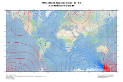
The World Magnetic Model is the standard model used by the U.S. Department of Defense,
the U.K. Ministry of Defence, the North Atlantic Treaty Organization (NATO) and the
International Hydrographic Organization (IHO), for navigation, attitude and heading
referencing systems using the geomagnetic field. It is also used widely in civilian
navigation and heading systems. The model is produced at 5-year intervals, with the
current model expiring on December 31, 2019. The current model WMM2015v2 is produced
jointly by the NGDC and the British Geological Survey (BGS). The model, associated
software, and documentation are distributed by NGDC on behalf of US National Geospatial-Intelligence
Agency and by BGS on behalf of UK Defence Geographic Centre. |