Delaware Bay, Delaware Benthic Habitats 2010 Geoform
de_db10-geoform_Metadata
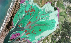 Sample of benthic cover data
The Coastal Program of Delaware's Division of Soil and Water conservation (DNREC),
the University of Delaware, Partnership for the Delaware Estuary, and the New Jersey
Department of Environmental Protection have partnered and are carrying out a bottom
and sub-bottom imaging project to identify and map the benthic habitat and sub-bottom
sediments of Delaware Bay and River. This project was initiated to better understand
the distribution of bottom sediment types, habitat biodiversity, and most importantly,
human's impact on the bay bottom and its living resources. The project integrates
the use of three types of acoustical systems: Roxann Seabed classification system,
chirp sub-bottom profiling, and multi-beam bathymetric mapping. Verification of the
acoustic data with bottom and sub-bottom sediments is performed through the collection
of bra banc core samples and underwater video images.
Original contact information:
Contact Org: NOAA Office for Coastal Management
Phone: 843-740-1202
Email: coastal.info@noaa.gov Show more...
Original contact information:
Contact Org: NOAA Office for Coastal Management
Phone: 843-740-1202
Email: coastal.info@noaa.gov Show more...
- Cite As: Office for Coastal Management, [Date of Access]: Delaware Bay, Delaware Benthic Habitats 2010 Geoform [Data Date Range], https://www.fisheries.noaa.gov/inport/item/47869.
gov.noaa.nmfs.inport:47869
| Download Data |
|
| Distribution Formats | Format not available
|
| Distributor | NOAA Office for Coastal Management (843) 740-1202 coastal.info@noaa.gov |
| Dataset Point of Contact | NOAA Office for Coastal Management (843) 740-1202 coastal.info@noaa.gov |
| Dataset custodian | NOAA Office for Coastal Management (843) 740-1202 coastal.info@noaa.gov |
| Time Period | 2004 to 2010 |
| Spatial Bounding Box Coordinates |
West:-75.6056
East:-75.16708
South:38.80217
North:39.83218
|
| Spatial Coverage Map | |
| Dataset Information |
|
| Associated Resources |
|
| Publication Dates |
|
| Data Presentation Form | mapDigital |
| Dataset Progress Status | Complete - production of the data has been completed |
| Data Update Frequency | As needed |
| Purpose | The Delaware Bay project has four principle goals. The first is to determine the location and extent of oyster reef habitats in upper Delaware Bay which will greatly improve the ability of Delaware and New Jersey to manage these commercial resources. The second goal is to evaluate short-nose, and atlantic sturgeon habitat. Sturgeon in the bay have shown an affinity for certain regions within the system. A better understanding of the conditions in these areas would improve the ability to assess the impact of dredging or other activities. A third goal was to identify potential borrow sites for beach re-nourishment materials. Finally, the high-resolution bathymetry collected in the bay will improve the understanding of sediment movement and other human impacts on the bay |
| Use Limitations |
|
| Dataset Citation |
|
| Publishers |
|
| Theme keywords | Global Change Master Directory (GCMD) Science Keywords
|
| Data Center keywords | Global Change Master Directory (GCMD) Data Center Keywords
|
| Place keywords | Global Change Master Directory (GCMD) Location Keywords
|
| Project keywords | InPort
|
| Stratum keywords |
|
| Use Constraints |
|
| Access Constraints |
|
| Other Constraints | Distribution Liability: NOAA provides no warranty, nor accepts any liability occurring from any incomplete, incorrect, or misleading data, or from any incorrect, incomplete, or misleading use of the data. It is the responsibility of the user to determine whether or not the data is suitable for the intended purpose. |
| Fees | Fee information not available. |
| Lineage Statement | |
| Source Datasets |
|
Last Modified: 2024-02-29T00:00:00