AIS Ship Traffic: Hawaii: 2008-2009: Binned: 1km
 Sample image.
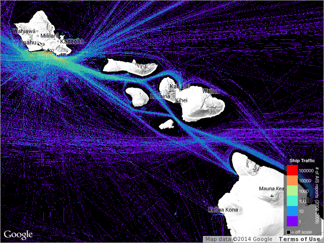
Ship traffic for the State of Hawaii, identifying the number of times a vessel occupied
each square kilometer during the period 2008-2009. The Automatic Identification System
(AIS) is an internationally-recognized shipboard broadcast system that communicates
information to shore-based stations and other AIS-equipped ships. The U.S. Coast Guard
(USCG) has developed rules applicable to both U.S. and foreign vessels that require
owners and operators of most commercial vessels to install and use AIS to increase
security and safety of maritime transportation. PacIOOS obtained AIS data from the
USCG Nationwide AIS (NAIS) project. While specific times for ship locations were redacted,
the data represent a cumulation over the two-year period 2008-2009 from which ship
frequency was computed at 1-km resolution.
Cite this dataset when used as a source.
- ais_hi_20082009_grid
ais_hi_20082009_grid
| Download Data |
|
| Distribution Formats |
|
| Distributor | Pacific Islands Ocean Observing System (PacIOOS) info@pacioos.org |
| Dataset Point of Contact | James T. Potemra University of Hawaii at Manoa jimp@hawaii.edu |
| Time Period | 2008-01-01T00:00:00Z to 2010-01-01T00:00:00Z |
| Spatial Bounding Box Coordinates |
West:200.0005
East:205.9995
South:18.0005
North:22.9995
|
| Spatial Coverage Map | |
| General Documentation |
|
| Associated Resources |
|
| Publication Dates |
|
| Dataset Progress Status | Status not available |
| Data Update Frequency | Data update frequency not available |
| Purpose | PacIOOS provides timely, reliable, and accurate ocean information to support a safe, clean, productive ocean and resilient coastal zone in the U.S. Pacific Islands region. |
| Originators |
|
| Resource Providers |
|
| Publishers |
|
| Acknowledgments |
|
| Theme keywords | GCMD Science Keywords
|
| Data Center keywords | GCMD Data Center Keywords
|
| Place keywords | GCMD Location Keywords
|
| Project keywords | GCMD Project Keywords
|
| Use Constraints | No constraint information available |
| Fees | Fee information not available. |
| Lineage Statement | 2010-04-01T00:00:00Z Data obtained from USCG/NAIS by J. Potemra. |
Last Modified: 2021-03-25
For questions about the information on this page, please email:jimp@hawaii.edu