Okeanos Explorer (EX1810): Mapping Deepwater Areas off the Southeast U.S. in Support of the Extended Continental Shelf Project

EX1810

browse graphic
Multibeam, single beam, and subbottom sonar data will be collected 24 hours a day. XBT casts will be conducted regularly for multibeam calibration. The ship's Scientific Computing System (SCS) will monitor and collect oceanographic, navigation, and meteorological data throughout the cruise.
Cite this dataset when used as a source.
  • ID not available.
Other Access Online access information not available.
Distribution Formats Format not available
    Distributor Distributor information not available
    Dataset pointOfContact Michael White
    NOAA/OAR/OER
    Dataset processor Michael White
    NOAA/OAR/OER
    Time Period 2018-10-03T00:00:00 to 2018-10-24T00:00:00
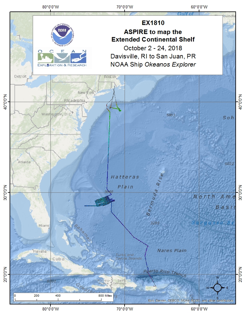
    Spatial Bounding Box Coordinates
    West:-75.38
    East:-65.79
    South:18.49
    North:40.98
    Spatial Coverage Map
    Associated Resources
    Publication Dates
    • publication:unknown
    Dataset Progress Status Planned - fixed date has been established upon or by which the data will be created or updated
    Data Update Frequency Data update frequency not available
    Purpose EX1810 Operations included the use of the ship's deep water mapping systems (Kongsberg EM302 multibeam sonar, EK60 split-beam fisheries sonars, Knudsen 3260 chirp sub-bottom profiler sonar, and Teledyne Acoustic Doppler Current Profiler), XBT and CTD casts in support of multibeam sonar mapping operations, and the ship's high-bandwidth satellite connection for real-time ship-to-shore communications. Operations were undertaken in the south east of Bermuda in the high seas.
    Publishers
      Publisher information not available.
    Acknowledgments
    • Credit for this cruise goes to the NOAA Office of Ocean Exploration and Research and its Okeanos Explorer Program.
    Place keywords None
    • Blake Plateau
    Keywords Ocean Exploration and Research (OER) Program Discovery Keywords
    • expedition
    • exploration
    • explorer
    • marine education
    • noaa
    • ocean
    • ocean discovery
    • ocean education
    • ocean exploration
    • ocean exploration and research
    • OER
    • ocean literacy
    • ocean research
    • science
    • scientific mission
    • scientific research
    • sea
    • stewardship
    • systematic exploration
    • technology
    • transformational research
    • undersea
    • underwater
    Keywords Ocean Exploration and Research (OER) Okeanos Explorer Discovery Keywords
    • okeanos explorer
    • okeanos
    • scientific computing system
    • SCS
    • noaa fleet
    • R337
    • multibeam
    • multibeam sonar
    • telepresence
    • sub-bottom profile
    • mapping survey
    • multibeam backscatter
    • water column backscatter
    • singlebeam sonar
    • single beam sonar
    • single-beam sonar
    • deep-sea exploration
    • high-definition underwater video
    • underwater video
    • exploration vessel
    Keywords Ocean Exploration and Research (OER) Marine Archaeology Keywords
    • archaeology
    • archaeological
    • conservation
    • conserve
    • crm
    • cultural resource management
    • historic
    • marine archaeology
    • maritime
    • maritime archaeology
    • nautical
    • nautical archaeology
    • preserve
    • protect
    • protection
    • submerged cultural heritage
    • submerged cultural resource
    • uch
    • underwater cultural heritage
    Use Constraints
    • Data use shall be credited to NOAA Office of Ocean Exploration and Research. No data access constraints, unless data are protected under the National Historic Preservation Act of 1966.
    Access Constraints
    • Data use shall be credited to NOAA Office of Ocean Exploration and Research. No data access constraints, unless data are protected under the National Historic Preservation Act of 1966.
    Fees Fee information not available.
    Acquisition Information (collection)
    Instrument
    • Kongsberg EM304
    • Simrad EK60
    • Simrad EK80
    • Knudsen CHIRP 3260
    • RM Young 61202V
    • RM Young 41382VC
    • RM Young 05106
    • Sippican XBT/XSV
    • SBE 45 Micro TSG
    • SBE 911plus CTD
    • SBE 32
    • POS/MV 320
    • Furuno GPS
    • Reson SVP 70
    • Ocean Surveyor ADCP
    • ECO FLNTU Fluorometer
    Platform
    • Okeanos Explorer (EX)
    Last Modified: 2024-12-31T08:51:34.318-05:00
    For questions about the information on this page, please email:oceanexplorer@noaa.gov