Total Sediment Thickness of the World's Oceans & Marginal Seas
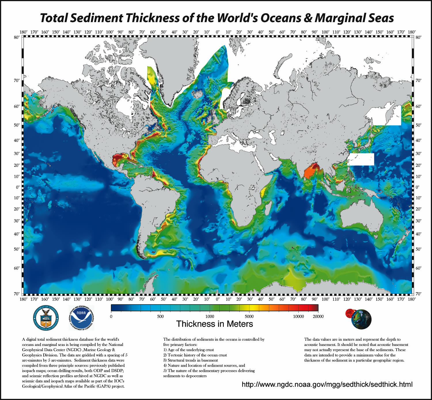 Image of total sediment thickness of the world's oceans and marginal seas.
A digital total-sediment-thickness database for the world's oceans and marginal seas
has been compiled by the NOAA National Geophysical Data Center (NGDC). The data were
gridded with a grid spacing of 5 arc-minutes by 5 arc-minutes. Sediment-thickness
data were compiled from three principle sources: (i) previously published isopach
maps including Ludwig and Houtz [1979], Matthias et al. [1988], Divins and Rabinowitz
[1990], Hayes and LaBrecque [1991], and Divins [2003]; (ii) ocean drilling results,
both from the Ocean Drilling Program (ODP) and the Deep Sea Drilling Project (DSDP);
and (iii) seismic reflection profiles archived at NGDC as well as seismic data and
isopach maps available as part of the IOC's International Geological-Geophysical Atlas
of the Pacific Ocean [Udinstev, 2003].
Cite this dataset when used as a source.
- ID not available.
gov.noaa.ngdc.mgg.geophysics:G01065
| Other Access | |
| Distribution Formats |
|
| Distributor | User Services DOC/NOAA/NESDIS/NCEI > National Centers for Environmental Information, NESDIS, NOAA, U.S. Department of Commerce 303-497-6826 ngdc.info@noaa.gov |
| Dataset Point of Contact | Barry W. Eakins Research Scientist NOAA National Centers for Environmental Information 303-497-6505 Barry.Eakins@noaa.gov |
| Time Period | 1979-01-01 to 2003-01-01 |
| Spatial Reference System | urn:ogc:def:crs:EPSG::4326 |
| Spatial Bounding Box Coordinates |
West:-180.0000
East:180.0000
South:-70.0000
North:79.0000
|
| Spatial Coverage Map | |
| Documentation links not available. | |
| Publication Dates |
|
| Data Presentation Form | mapDigital |
| Dataset Progress Status | Complete - production of the data has been completed |
| Data Update Frequency | As needed |
| Purpose | To create a global sediment-thickness database for use by researchers and interested public. |
| Originators |
|
| Publishers |
|
| Theme keywords | Global Change Master Directory (GCMD) Science Keywords
|
| Data Center keywords | Global Change Master Directory (GCMD) Data Center Keywords
|
| Place keywords | Global Change Master Directory (GCMD) Location Keywords
|
| Use Constraints |
|
| Access Constraints |
|
| Fees |
|
| Processing Steps |
|
| Processing Steps |
|
Last Modified: 2017-09-25
For questions about the information on this page, please email:Brian.Meyer@noaa.gov